Helen F
Warrington
|
931 of 974
Fri 31st Mar 2023 12:06pm
 There are little gems in unexpected places. Are toilet jackets those onesies with the back flap?  |
|
Streets and Roads -
Broadgate
|
NeilsYard
Coventry
|
932 of 974
Fri 31st Mar 2023 12:08pm
Helen  - Was 19 up towards Cross Cheaping? |
|
Streets and Roads -
Broadgate
|
Helen F
Warrington
|
933 of 974
Fri 31st Mar 2023 12:17pm
No, it was closer to the High Street, east side. It was next to the single window width building. Where J Lyons & Co was.
|
|
Streets and Roads -
Broadgate
|
Earlsdon Kid
Argyll & Bute, Scotland
|
934 of 974
Fri 31st Mar 2023 7:37pm
On 14th Jun 2020 10:11pm, Prof said:
A slightly wider photo of Broadgate taken on my first box camera between late 50's and early 60's I think!
|
|
Streets and Roads -
Broadgate
|
NeilsYard
Coventry
|
935 of 974
Mon 3rd Apr 2023 11:22am
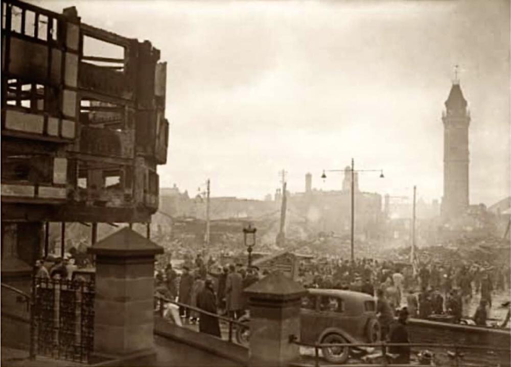
We've had a similar view before but I don't think it was this actual image - Thanks to Gray Forster on FB - Another including The Pru which appears to be the sad morning after -
|
|
Streets and Roads -
Broadgate
|
bk
Coventry
|
936 of 974
Thu 27th Apr 2023 10:04am
Been scanning the new Arthur Cooper set, probably about 1000 negatives, and this popped up. I'll add them to Cov Dig and to the spreadsheet soon if people are willing to help, but thought I'd tease a bit.
|
|
Streets and Roads -
Broadgate
|
Rob Orland
Historic Coventry
|
937 of 974
Thu 27th Apr 2023 10:18am
Hey, what a cracker! I'd initially guess 1938/39 while our Wetherspoon's (sorry, Timothy White's  ) was being built.... with a modern steel-framed structure, despite how the finished article looks. |
|
Streets and Roads -
Broadgate
|
Helen F
Warrington
|
938 of 974
Thu 27th Apr 2023 10:38am
Excellent.  I know that there was a fantastic picture looking the other way as they demolished that corner. Looking right into the centre of the old block. Sadly the newspaper copy is terribly poor quality. Fingers crossed. |
|
Streets and Roads -
Broadgate
|
NeilsYard
Coventry
|
939 of 974
Thu 27th Apr 2023 2:06pm
Belter Is he on the roof of one of the old Broadgate properties? |
|
Streets and Roads -
Broadgate
|
Helen F
Warrington
|
940 of 974
Sat 29th Apr 2023 1:52pm
Judging from the parapet and the two tone chimney, the view is from Slingsby? |
|
Streets and Roads -
Broadgate
|
Diesel74
Cornwall
|
941 of 974
Fri 14th Jul 2023 10:06am
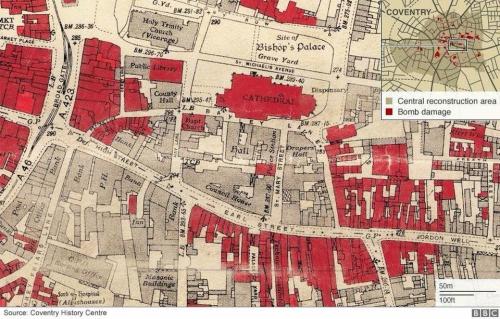
Okay, so here's a question for all you knowledgeable people.
On the famed Coventry History Centre map of the city centre after the night of November 14 shows the block in front of the old library where the Prudential was built.
It is the same block on maps from before the Pru. Did they demolish what they wanted and build the Pru to fit? Is this an anomaly?
Also, what were the businesses at the back of the Pru towards Derry Lane?
Another related question. The red block to the left of the library going up Broadgate, and in front of County Hall - what were those businesses/buildings?
And finally, there is a grey spot on the Prudential block, as I'll call it - one business survived the bombs? Any ideas?
Many thanks in advance,
Mark
|
|
Streets and Roads -
Broadgate
|
NeilsYard
Coventry
|
942 of 974
Fri 14th Jul 2023 10:30am
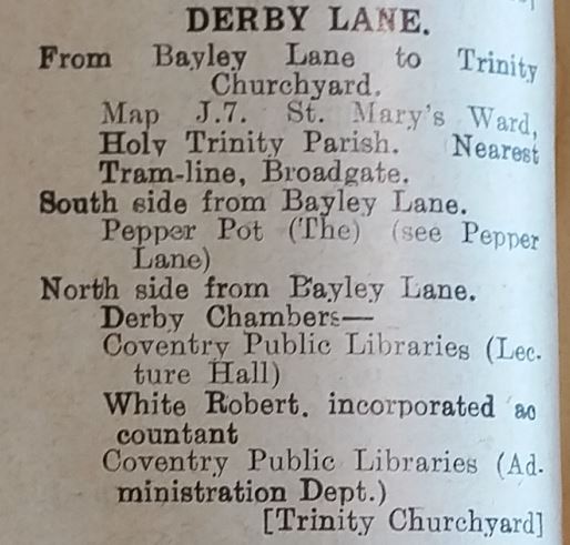
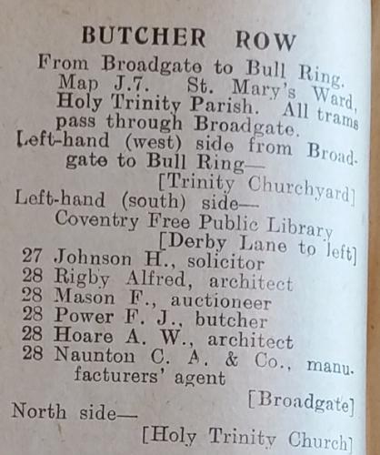
I'm sure someone can fill in the details Mark but a quick check on the 1936 Directory (Thanks Bern!) for Derby Lane (not Derry!) -
|
|
Streets and Roads -
Broadgate
|
Helen F
Warrington
|
943 of 974
Fri 14th Jul 2023 10:35am
Hi Mark.
It's quite an out of date map that they used. New map making was probably stopped due to the war, Pre Prudential. The block south of the Drapers Hall is shown intact but it had been demolished some time.
There are a lot of businesses in the areas you want to know about. The nearest suitable directory would be the street section from 1937 but matching that map to the businesses isn't that easy because of the changes in the map, businesses in the subsequent years. For instance the directory might show a different business on that corner where the Pru was built.
|
|
Streets and Roads -
Broadgate
|
Helen F
Warrington
|
944 of 974
Fri 14th Jul 2023 2:35pm
I checked the map and it was also dated 1937, so the directory might be consistent with it but not with what was actually there at the time. I don't know how long it took to make either directory or map but there was a lag between the surveys and the publication. The block between Derby Lane and Broadgate was also multi layered, with not every building with a street front address. The map isn't detailed enough to show each dividing wall. It also doesn't show property numbers and matching those up is difficult. The directories do mention businesses where they occupy different levels of a street front building. This was quite common in that area.
On the Derby Lane topic, there are before and after views of the west side of the street looking south. The brick building on the right was rebuilt and in the second photo, Frank Mason & Co are occupying it. That's the building that survived the war. Almost certainly because it was a newbuild. The rather magnificent but decaying timber building beyond it in the photos was demolished before the war, so while it is marked as destroyed, it wasn't. Whether they had replaced it by the time the war started, I don't know. The demolition probably explains why Derby Lane had no street numbers in the directory in 1936 and 1937.
Finally, working out properties on corners can be hard because it's not always easy to tell which street they are listed on. So the building on the corner of Derby Lane, behind the Pru, could be be on Derby Lane, Trinity Churchyard or the, by then non existent, Butcher Row. It turns out to be the latter. I think, but I'm not sure, that these don't include the plot for the Pru.
|
|
Streets and Roads -
Broadgate
|
Helen F
Warrington
|
945 of 974
Fri 14th Jul 2023 4:50pm
To clarify a the point about the land to the south of Drapers' Hall. It was completely cleared by March 1939, which shows how quickly they were doing things at the time. The plan for the land was to build the art gallery and museum but after the war they swapped to the other side of Bayley Lane. |
|
Streets and Roads -
Broadgate
|

