herberts lad
Exhall
|
91 of 379
Fri 27th May 2016 8:48pm
The water tank as described in the above posts became the basis of the dive bar at the Godiva public house that was built on the very same corner.
When I went in there I often thought I was sitting in the old water tank.
There was another one built not too far away adjacent to the cathedral wall by Drapers Hall. |
|
Local History and Heritage -
More mystery scenes
|
Midland Red
|
92 of 379
Fri 27th May 2016 8:59pm
Posted on the Bayley Lane thread:
|
|
Local History and Heritage -
More mystery scenes
|
Dreamtime
Perth Western Australia
|
93 of 379
Sat 28th May 2016 5:20pm
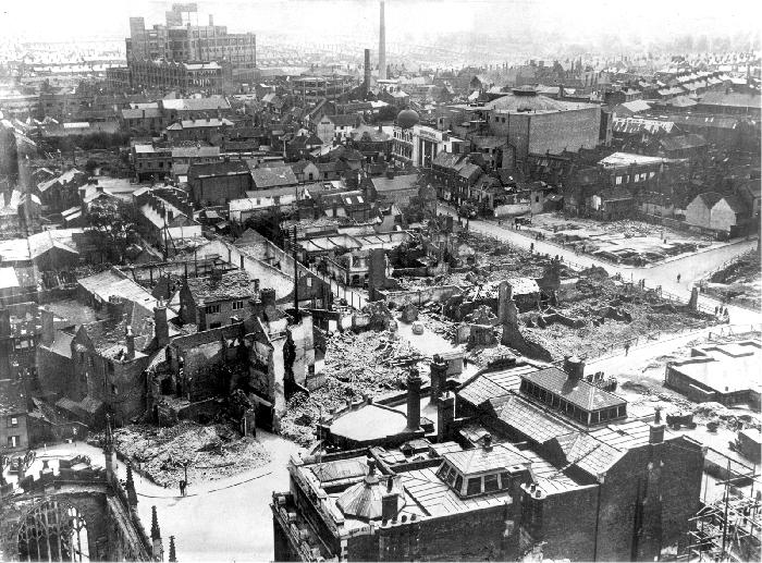
Well, I am trying to sort that one out. Is that the old Gaumont I see at the top in the middle of the picture, or have I lost my sense of direction again.
Thanks MR. |
|
Local History and Heritage -
More mystery scenes
|
Midland Red
|
94 of 379
Sat 28th May 2016 5:29pm
Yes it is. Much Park Street goes away to the right, off Jordan Well.
Cathedral ruins bottom left hand corner, Drapers Hall bottom centre.  |
|
Local History and Heritage -
More mystery scenes
|
NormK
bulkington
|
95 of 379
Sun 29th May 2016 1:15pm
20 years later

|
|
Local History and Heritage -
More mystery scenes
|
Derrickarthur
Coventry
|
96 of 379
Sun 29th May 2016 1:26pm
On 27th May 2016 8:59pm, Midland Red said:
Posted on the Bayley Lane thread:
The ruined street running from Drapers Hall must be Freeth Street which dog-legs to the right to join Jordan Well just before the Gaumont. My Grandmother was born in Freeth Street in March 1891 and appears on the April 1891 census |
|
Local History and Heritage -
More mystery scenes
|
Heathite
Coventry
|
97 of 379
Sun 29th May 2016 2:27pm
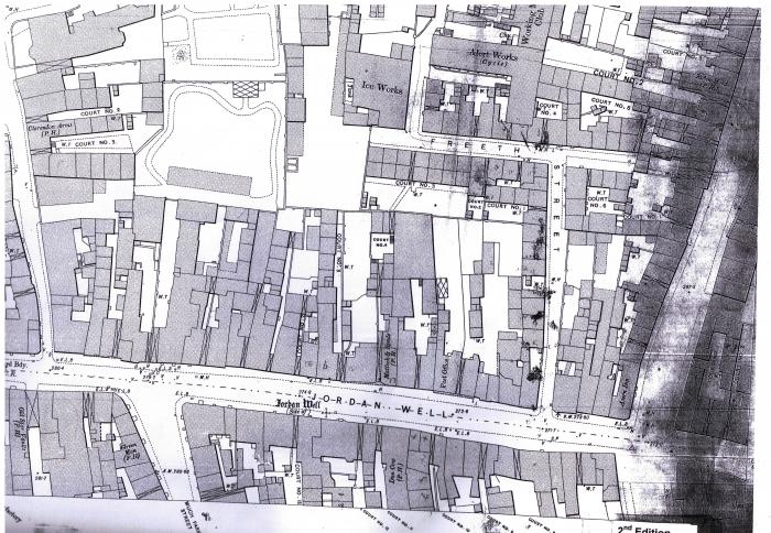
I don't mean to teach granny how to suck eggs but I have this pre-funny munny map which shows the site of Freeth Street. It was a bit before my time or at least when I was very young.
The map is priced at one shilling and six pence. The part I have uploaded is taken from the city centre inset.
 |
|
Local History and Heritage -
More mystery scenes
|
dutchman
Spon End
|
98 of 379
Sun 29th May 2016 5:57pm
Street maps are never to scale, you could walk past the entrance to Freeth Street every day and not realise it was there.
|
|
Local History and Heritage -
More mystery scenes
|
Heathite
Coventry
|
99 of 379
Sun 29th May 2016 6:49pm
I assume you are referring to the Jordan Well entrance, but can I ask, does this also apply to the Cox Street entrance? |
|
Local History and Heritage -
More mystery scenes
|
Derrickarthur
Coventry
|
100 of 379
Sun 29th May 2016 7:27pm
Not sure of the date of these maps but they must be around 1900 or possibly earlier. Neither map shows a throughway to Cox Street. The Ice Works and Alert Works (cycle) in Freeth Street are interesting.

|
|
Local History and Heritage -
More mystery scenes
|
Heathite
Coventry
|
101 of 379
Sun 29th May 2016 7:45pm
Thank you for the interesting maps. May I suggest that after the bombing, an opening was made possible through to Cox Street. The evidence is there on the 'funny munny' map. |
|
Local History and Heritage -
More mystery scenes
|
dutchman
Spon End
|
102 of 379
Sun 29th May 2016 8:02pm
This map is circa 1954:

|
|
Local History and Heritage -
More mystery scenes
|
pixrobin
Canley
|
103 of 379
Thu 9th Jun 2016 4:20pm
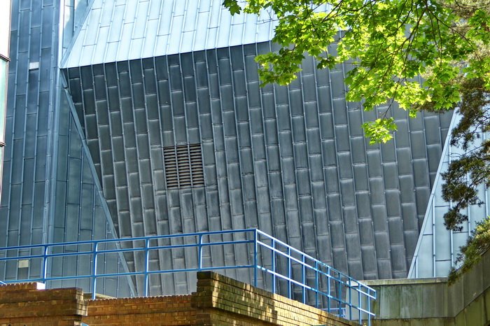
Here's a picture I took in Coventry earlier today. Anyone care to guess what building it is.
|
|
Local History and Heritage -
More mystery scenes
|
Old Lincolnian
Coventry
|
104 of 379
Thu 9th Jun 2016 4:24pm
I won't say what it is but how did you get it to look that good? |
|
Local History and Heritage -
More mystery scenes
|
mickw
nuneaton
|
105 of 379
Thu 9th Jun 2016 4:25pm
Is it the sports centre? |
|
Local History and Heritage -
More mystery scenes
|

