

|
Prof
Gloucester |
76 of 110
Tue 2nd Oct 2018 9:43am
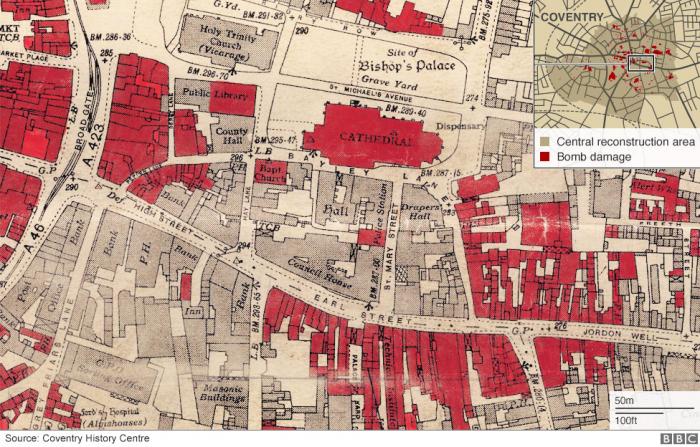
Another map of the central area from a Blitz item on Pinterest.
|
| Streets and Roads - Spicerstoke (inc Trinity Lane) | |
|
Prof
Gloucester |
77 of 110
Mon 29th Oct 2018 2:03pm
 |
| Streets and Roads - Spicerstoke (inc Trinity Lane) | |
|
Kaga simpson
Peacehaven, East Sussex |
78 of 110
Tue 30th Oct 2018 5:10pm
Prof,
Another map with Derby Lane, Trinity Street, etc, but still no mention of Spicerstoke. I have yet to see a map with Spicerstoke mentioned except for this forum? Neither is it mentioned in any books I have. At the corner of Cross Cheaping and Trinity Churchyard were Baildon and Coleman, the chemists; next door, also in the churchyard, was Mr Downes.
In Derby Lane was the inn known as the Black Moors Head, which was almost opposite the Popes Head, another old house. The Moors Head was much frequented by farmers that dined there on market days, and it vied with the the Craven and the Castle and the Talbot for their custom.
The corner of Cross Cheaping/Butcher Row was the Spirit Vaults, owned by James Weare who was Coventry Mayor 1824-5-6.
The Churchyard joined Cross Cheaping and Derby Lane.
Edited by Midland Red, 30th Oct 2018 5:38 pm (Links to inns added)
|
| Streets and Roads - Spicerstoke (inc Trinity Lane) | |
|
David H
Lancashire |
79 of 110
Sat 3rd Nov 2018 12:33am
I have been flicking through some old newspaper articles that mention Spicerstoke in Coventry, and offer the following which although does not offer any radically new information, may be of interest.
The "Nottingham Journal" on 22nd July 1898 discusses Spicerstoke, and says "Spicer-Stoke was where Spicers, or as we call them now - grocers - lived and worked." Part of the definition of Spicer is grocer so it may well be possible that spice-selling did not take place here - only more humble fruit and veg! It appears that from medieval times, this area was a hive of trading activity, perhaps the shopping centre of its day, and that trades such as grocery, butchery, poulterers, ironmongery etc, operated in their own areas, which became named after them. The "Nottingham Journal" suggests that this distribution may have originated from the activity of trade guilds.
In terms of its location, the "Coventry Herald" on 25th June 1915 stated that the 1851 Ordnance map shows that ". . . a mill stands in New Buildings, the lane between Trinity Church and Butcher Row is Trinity Church side, and the short length between the Church and Cross Cheaping is the Old Spicerstoke, though on the map it is not identified".
Further to this, the "Coventry Standard" on 21st May 1915 reported that at one time (which I think was up to the early 1800's) a passage ran from the Spicerstoke into the churchyard, along the side of the Church and through an arch in the south transept, a vaulted passage running through this, to emerge at the other side. The arch was provided with a turnstile, and a hanging oil lamp at night. The blocked-up entrance arch can still be seen in the transept wall, but the other end is covered up when the later organ chamber was built. Whether anything remains of the passageway inside the church I do not know.
The "Coventry Herald" on 18th September 1937 published an article called "Trinity Church & its mysteries." This included an illustration of what appears to be the part of the Spicerstoke by the Church. This indicates that the path occupied part of the later churchyard, hugging the Church wall and ending in a flight of steps up to the archway through the transept.
Intriguingly the "Coventry Herald" of 6th March 1931 states "Among the houses which contribute to fine street views are the Dovecote House in the old Spicerstoke, now Trinity Church yard . . ." What was the Dovecote House?
Finally the "Coventry Herald" on 16th August 1936 gave a report of the public hanging of Mary Ball on 9th August 1849 on ground in the Spicerstoke. She was brought out from the gate of the nearby Coventry Gaol, and hanged at a spot just opposite where the Free Library later stood. This tragic event was witnessed by around 20,000 people and was the last public hanging in Coventry. It is interesting that the newspaper describes it as occurring in the Spicerstoke as I believe it was in the vicinity of where the Coventry Cross now stands. That would mean that the general description of the Spicerstoke extends through the transept passage through to Cuckoo Lane where the execution took place.
|
| Streets and Roads - Spicerstoke (inc Trinity Lane) | |
|
Kaga simpson
Peacehaven, East Sussex |
80 of 110
Sat 3rd Nov 2018 1:12pm
David H
Interesting, my book says she was executed in front of the Coventry gaol (which is the same place) for poisoning her husband at Nuneaton. After that the executions took place at Warwick gaol. But all those house photos on this forum are registered address by the council as Churchyard, but I agree you have found it mentioned so there must be some truth in it. I just wish I had the energy to pursuit as you people can. Thanks for the info. Kaga
|
| Streets and Roads - Spicerstoke (inc Trinity Lane) | |
|
Helen F
Warrington |
81 of 110
Sat 3rd Nov 2018 4:31pm
Ah, an interesting set of details David H. The following pictures show the archway in the south trancept of Holy Trinity. The modern south trancept is not big enough to accomodate the arch and must have been rebuilt slightly shorter. The right hand picture shows the demolition of houses prior to the construction of the gaol (the 3rd gaol in the area, the second being where the County Court is now). This went back, almost to Derby Lane
  Since it's not marked on any map, it's not obvious if the Spicerstoke ends at Derby Lane or Cuckoo Lane (a modern name). Certainly the shops ended at Derby Lane and the other buildings were probably accomodation (eg for the vicar). I don't know which was the Dovecot House but for it to have still been there in 1931, I'm guessing it was the fancy one on the north west corner of Derby Lane.
Spicer meaning grocer is a bit misleading (I had to look it up) as the grocer used to be the term for bulk sales but generally they sold such foods as could be stored for longer periods, like spices, dried fruits, tea, and coffee. And perhaps tallow and other commodities. Not to be confused with green grocer (which I did).
Spicer, grocer, spicer en gross
Since it's not marked on any map, it's not obvious if the Spicerstoke ends at Derby Lane or Cuckoo Lane (a modern name). Certainly the shops ended at Derby Lane and the other buildings were probably accomodation (eg for the vicar). I don't know which was the Dovecot House but for it to have still been there in 1931, I'm guessing it was the fancy one on the north west corner of Derby Lane.
Spicer meaning grocer is a bit misleading (I had to look it up) as the grocer used to be the term for bulk sales but generally they sold such foods as could be stored for longer periods, like spices, dried fruits, tea, and coffee. And perhaps tallow and other commodities. Not to be confused with green grocer (which I did).
Spicer, grocer, spicer en gross
|
| Streets and Roads - Spicerstoke (inc Trinity Lane) | |
|
David H
Lancashire |
82 of 110
Mon 5th Nov 2018 4:58pm
Kaga - I hope you are feeling better. I agree that the roadway to the side of the church is, I think called "Trinity Churchyard", which I must admit confused me a bit because when I described the path through the south transept, I meant that it actually appeared to encroach into the churchyard - or graveyard itself. Certainly there are gravestones present now where that path ran up until the early 1800's.
Helen - Fantastic illustrations. I have read on the British History Online site that in 1499 a hall was built for the clergy to live in on land to the south of Holy Trinity, called the Jesus Hall. I understand that this hall actually joined the church at the south transept, and so the path around this part of the church was blocked. Therefore a passageway was probably created then through the south transept so that pedestrian traffic could be resumed. Also the existing transeptal chapel, cut through by the new footpath was relocated to a new chamber above the new vaulted stonework of the passage. The chapel was probably furnished with the Jesus altar, and external stairs were built for access. From then on the passageway was known as the "Jesus Passage" and continued in use until 1834 when the buildings to the south of the church were cleared to allow for the extension of Coventry Gaol. With the external roadway re-established, the "Jesus Passage" was closed, the entrances blocked up with stone, and the south transept once again opened to the church, making the external stairs obsolete.
I think the western blocked-up archway visible today is the original, as are the well-worn chapel stairs which also survive. I am no expert on this building, and may be totally wrong, but do not think that although a considerable amount of work has taken place on the south transept, these features are a later addition. I think a new organ chamber was built in around 1855 next to it which has removed any evidence of the arch on the eastern side. The existing blocked-up arch has a distinctive pointed top which appears to be replicated in the first of your illustrations, and if original is a tangible link to the pathway in the Old Spicerstoke.
|
| Streets and Roads - Spicerstoke (inc Trinity Lane) | |
|
Kaga simpson
Peacehaven, East Sussex |
83 of 110
Mon 5th Nov 2018 5:48pm
David H, Helen F.
Wow, you both leave me breathless. I have a photo of Jesus's birthplace, there's a great stone block above his head - guess he got blocked off from going to heaven as well.
As for the gross fat lady that lived a few doors away?
|
| Streets and Roads - Spicerstoke (inc Trinity Lane) | |
|
Helen F
Warrington |
84 of 110
Mon 5th Nov 2018 9:31pm
Kaga, nothing was over until she sang.
David H, the walled up arch doesn't look big enough to be the original as the drawings and painting look like it went up to at least the top step of the stairs. The archway blocks may have been reused though. The 1850 map looks like a wiggly path made its way to it, so there was a normal doorway after there was a passage.
|
| Streets and Roads - Spicerstoke (inc Trinity Lane) | |
|
Kaga simpson
Peacehaven, East Sussex |
85 of 110
Wed 7th Nov 2018 11:47am
Helen F
This one didn't sing much - we stole her knee-deeps (bloomers) off the clothes line, there was enough elastic for about six catapults, and enough fabric to cover a haystack.
 |
| Streets and Roads - Spicerstoke (inc Trinity Lane) | |
| Helen F |
86 of 110
Wed 7th Nov 2018 3:36pm
|
|
Prof
Gloucester |
87 of 110
Wed 7th Nov 2018 3:53pm
Neils post #57, is this Dovecot House? And is this the same house front facing, Helen F post #55? It seems to me it probably is!
|
| Streets and Roads - Spicerstoke (inc Trinity Lane) | |
|
Helen F
Warrington |
88 of 110
Wed 7th Nov 2018 4:22pm
Yes Prof, I think that was Dovecot House. The two pictures are of the same building. Had it been an earlier reference it could have been the other side of Derby Lane (there is a roof that suggests holes for birds) but that side was demolished for the library. I've found at least one image with a dovecot in the roof - on a yard off Much Park street. The house you reference had a little window in the gable, maybe it was a dove door originally?
|
| Streets and Roads - Spicerstoke (inc Trinity Lane) | |
|
Prof
Gloucester |
89 of 110
Wed 7th Nov 2018 4:30pm
Thanks very much Helen, it looked such an interesting building, especially looking up Cuckoo Lane from the Spicerstoke, towards the Gulson Library. I missed so much being born ten years or so later than Kaga!
|
| Streets and Roads - Spicerstoke (inc Trinity Lane) | |
|
Prof
Gloucester |
90 of 110
Mon 19th Nov 2018 8:02pm
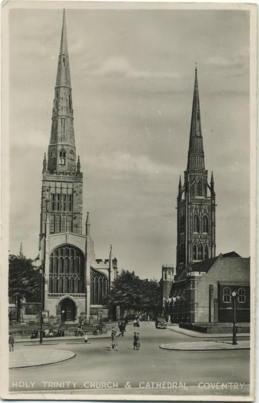
A fine view c.1937
 |
| Streets and Roads - Spicerstoke (inc Trinity Lane) | |

Website & counter by Rob Orland © 2025
Load time: 657ms