
|
Heathite
Coventry |
46 of 110
Sat 8th Oct 2016 7:38am
P message for you NeilsYard about maps in your inbox. |
| Streets and Roads - Spicerstoke (inc Trinity Lane) | |
|
NeilsYard
Coventry Thread starter
|
47 of 110
Thu 14th Sep 2017 1:17pm
Just researching something and referenced Anne's post 19 and the mention of Richard LeSpicer - came across this from British History online:
Grant of a Corrody to Richard Le Spicer by his Son.
|
| Streets and Roads - Spicerstoke (inc Trinity Lane) | |
|
Kaga simpson
Peacehaven, East Sussex |
48 of 110
Tue 24th Jul 2018 9:03am
Questions and suggestions
I believe Spicerstoke went out of fashion a century ago, became the churchyard?
I believe your photo's lose half of Spicerstoke or churchyard to Broadgate?
Those flower beds were the back yards of the right-hand shops of Butcher Row?
The church services after WWI, did the soldiers walk through Spicerstoke or the churchyard?
Butcher Row ran more or less down the now Trinity Street
The big black and white building (chemist) was not even in Butcher Row but in the small lane behind Butcher Row.
Behind the churches was the graveyard, so does the New Cathedral sit on the old graveyard?
I believe MR said Kaga's memory wasn't quite correct, it didn't go down that far - you're thinking of New Buildings.
I would say Butcher Row went down then swung left, about half-way down the now Trinity Street, continued into Ironmonger Row and into the Burges.
There was an alleyway that cut through either Butcher Row or Ironmonger Row, led into the Bull Ring and out on to the corner of Hales Street - I can't remember New Buildings being mentioned at anytime.
We must remember that you can look at old maps and lists today that were nothing like in the years or months in between.
We also must remember I was a child at the time so???? |
| Streets and Roads - Spicerstoke (inc Trinity Lane) | |
|
Helen F
Warrington |
49 of 110
Tue 24th Jul 2018 3:21pm
I believe Spicerstoke went out of fashion a century ago, became the churchyard?
The name was based on the spice selling activities of the area and probably started to fade after they stopped selling spices. Originally places had no numbers so roads were broken up into short sections with different names. There was a road that ran from Broadgate to New Street but the short section at the south (top) end of Butcher Row was the Spicerstoke.
The graveyard was more east than the Spicerstoke, so although the road was moved from flush against the church to its current position, it didn't affect the Spicerstoke.
I believe your photo's lose half of Spicerstoke or churchyard to Broadgate?
The Spicerstoke is now the bit of Broadgate to the north of Wilko.
Those flower beds were the back yards of the right-hand shops of Butcher Row?
No, the path along the back of those houses was very small and the current Trinity Lane probably covers the tiny yards too. The wall around Holy Trinity doesn't look like it has changed route since at least 1850. The flower beds and the grass now in front are probably a better marker of where the buildings were.
The church services after WWI, did the soldiers walk through Spicerstoke or the churchyard?
Dunno.
Butcher Row [and the Bull Ring at the north end] ran more or less down the now Trinity Street.
Butcher Row was at the south end butting up to the east/west Spicerstoke. In the middle Priory Row went off to the east. After that the road was called the Bull Ring. To the west was Little Butcher Row and then the Bull Ring Butted up to Ironmonger Row heading roughly east/west. To the west of Ironmonger Row was the Burges at a T junction. To the north but not in line with the Bull Ring was Palmer Lane. To the east of Ironmonger Row was New Buildings (a continuation of the same road) that curved round, split and one branch entered Hales Street. Trinity Street cuts through from Broadgate, through Butcher Row and the Bull Ring but the section between Ironmonger Row and Hales Street follows no road and just goes through what was houses, gardens and the cattle market.
The big black and white building (chemist/[Flying Standard]) was not even in Butcher Row but in the small lane behind Butcher Row.
It didn't exist at the same time as Butcher Row but was built on the site of 2 buildings, the western most of which did front onto Butcher Row. The half timbered Lych Gate Cottages that still exist at the back of the Flying Standard were on Priory Row. The steps are modern and originally the road entered Butcher Row/Bull Ring.
Behind the churches was the graveyard, so does the New Cathedral sit on the old graveyard?
The south part of it does. The north half sits on what was previously Georgian houses and gardens and before that was probably the graveyard of St Mary's Priory.
I believe MR said Kaga's memory wasn't quite correct, it didn't go down that far - you're thinking of New Buildings
I would say Butcher Row went down then swung left, about half-way down the now Trinity Street, continued into Ironmonger Row and into the Burges.
Butcher Row/Bull Ring did curve left looking north but it made a slanting T junction with Ironmonger Row. New Buildings (silly name) to the right of the Bull Ring came out at what was the cattle market off Hales Street, not to be confused with the Bull Ring which was the northern part of Butcher Row.
There was an alleyway that cut through either Butcher Row or Ironmonger Row, led into the Bull Ring and out on to the corner of Hales Street - I can't remember New Buildings being mentioned at anytime.
I imagine that the words 'new buildings' just bounced off as an unlikely description of the houses. Alternatively both Palmer Lane and several yards cut through to the cattle market from Ironmonger Row. |
| Streets and Roads - Spicerstoke (inc Trinity Lane) | |
|
Kaga simpson
Peacehaven, East Sussex |
50 of 110
Tue 24th Jul 2018 7:00pm
Helen F
Then we more or less agree to most of it - even in the early thirties, Palmer Lane and that area were higgledy piggledy yards and odd buildings but I did think that Little Butcher Row went through to the Burges. But I have my doubts about the selling of spices at any time, just don't fit in with my thinking. But thank you, Helen. |
| Streets and Roads - Spicerstoke (inc Trinity Lane) | |
|
Midland Red
|
51 of 110
Tue 24th Jul 2018 7:17pm
Look at the 1900 map here  |
| Streets and Roads - Spicerstoke (inc Trinity Lane) | |
|
Helen F
Warrington |
52 of 110
Tue 24th Jul 2018 8:02pm
Yes Kaga, Little Butcher Row did go from the Burges to the Bull Ring. It emerged onto the Burges almost opposite West Orchard. The Bull Ring end was just about the opposite of the original gateway to St Mary's Cathedral.
The spices were well before your time Kaga and perhaps explain the fancy buildings on the south side of the Spicerstoke. Very good money in spices in the Tudor and medieval eras.
Corrected to read Bull Ring not Yard - thanks to MR |
| Streets and Roads - Spicerstoke (inc Trinity Lane) | |
|
Osmiroid
UK |
53 of 110
Wed 25th Jul 2018 2:30am
Little Butcher Row onto Cross Cheaping, still Cross Cheaping to at least where the original Ironmonger Row entrance was.

|
| Streets and Roads - Spicerstoke (inc Trinity Lane) | |
|
Kaga simpson
Peacehaven, East Sussex |
54 of 110
Wed 25th Jul 2018 12:14pm
Osmiroid,
Thanks, the whole time I lived in Coventry no one bothered if you called it the Burges or Cross Cheaping - it was one and the same thing, except if you lived there or was a postman. Once they built Trinity Street and Owen Owen's all those smaller streets went off the radar kind of thing, that is until this forum brought them all back into light. |
| Streets and Roads - Spicerstoke (inc Trinity Lane) | |
|
Helen F
Warrington |
55 of 110
Thu 26th Jul 2018 10:48pm
An image for Kaga. The east end of the Spicerstoke as seen through the gate to Holy Trinity. The walls, railings and gates were relatively modern and the roadway was originally lower. It hugged the wall of the church and went under an extended south transept, probably to allow rich patrons to alight in the dry.
Photo for sale at AbeBooks
 |
| Streets and Roads - Spicerstoke (inc Trinity Lane) | |
|
Kaga simpson
Peacehaven, East Sussex |
56 of 110
Fri 27th Jul 2018 9:28am
Thanks HelenF. |
| Streets and Roads - Spicerstoke (inc Trinity Lane) | |
|
NeilsYard
Coventry Thread starter
|
57 of 110
Fri 3rd Aug 2018 5:05am
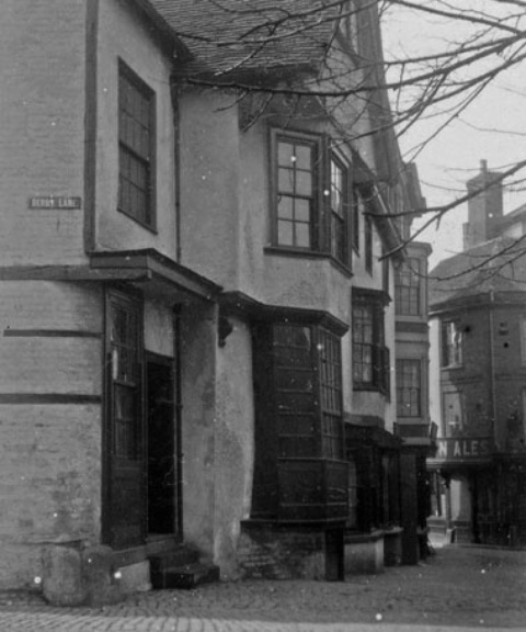
Great find Helen I think this one was Osmiroid's - the side of the same building with the walk through at the southern end of Butcher Row heading towards Broadgate in the background.
|
| Streets and Roads - Spicerstoke (inc Trinity Lane) | |
|
Kaga simpson
Peacehaven, East Sussex |
58 of 110
Fri 3rd Aug 2018 2:33pm
Helen, Neil.
I believe the pub on the right was knocked down with Butcher Row in '36 but the houses on the left remained until '39 when I believe all the railings round the churches went to salvage. At the other end and between the churches there were a good many headstones, and trees making it a very scary area to walk through at night alone, but this we did as kids daring each other. |
| Streets and Roads - Spicerstoke (inc Trinity Lane) | |
|
Prof
Gloucester |
59 of 110
Wed 15th Aug 2018 6:36pm
Quite overwhelmed Neil and Helen F by being transported into the parts of Coventry I never knew, though times I walked through Cuckoo Lane, never imagining the interesting buildings once there. I do remember the Gulson Library very well, but of course never knew Butcher Row, Bull Ring, but always knew of them! |
| Streets and Roads - Spicerstoke (inc Trinity Lane) | |
|
Osmiroid
UK |
60 of 110
Wed 15th Aug 2018 7:00pm
I know the building that was the second one down on Cross Cheaping and the Royal Vaults (the beginning of Cross Cheaping) and Hiltons (the bottom of Broadgate) were demolished. Not sure what else the council destroyed on Broadgate and Cross Cheaping?
|
| Streets and Roads - Spicerstoke (inc Trinity Lane) | |

Website & counter by Rob Orland © 2024
Load time: 200ms