Heathite
Coventry
|
31 of 233
Fri 29th Apr 2016 9:11pm
|
|
Streets and Roads -
Hales Street
|
Heathite
Coventry
|
32 of 233
Fri 29th Apr 2016 9:35pm
Maybe this is why it keeps filling up? The Sherbourne is quite close.
|
|
Streets and Roads -
Hales Street
|
Helen F
Warrington
|
33 of 233
Fri 29th Apr 2016 9:59pm
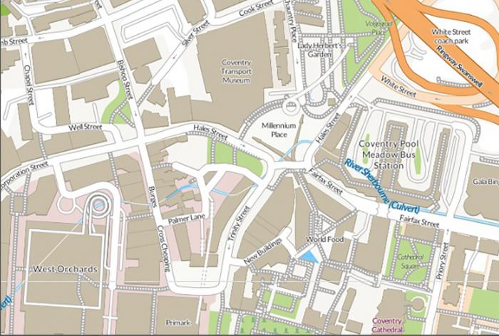
Originally there was a stream from St Agnes Well, Radford Brook and the Shebourne all meeting together at roughly that point in a big mill pond. While the rivers are in tunnels, the tendency of the ground to collect water probably never stopped. Checking the map, the point they're digging was probably a dry bit but the area is obviously a natural bowl. The roads are built over the water tracks, possibly pushing the water table sideways.
There was also bits of metal pipe in there, so they might have hit the drain from the shops up the hill. Nice pictures by the way. We watched the guy in the digger for some time but were afraid he'd slip in. |
|
Streets and Roads -
Hales Street
|
dutchman
Spon End
|
34 of 233
Fri 29th Apr 2016 11:05pm
The same thing happened when they built Woolworths, the city engineer said it was a nightmare. I'm guessing his predecessor had the same problem when they constructed the lower section of Trinity Buildings.
|
|
Streets and Roads -
Hales Street
|
Helen F
Warrington
|
35 of 233
Sat 30th Apr 2016 12:20am
As each building went in, there were less places for the water to go.
|
|
Streets and Roads -
Hales Street
|
dutchman
Spon End
|
36 of 233
Sat 30th Apr 2016 12:40am
It could be worse! 

|
|
Streets and Roads -
Hales Street
|
Helen F
Warrington
|
37 of 233
Sat 30th Apr 2016 7:13am
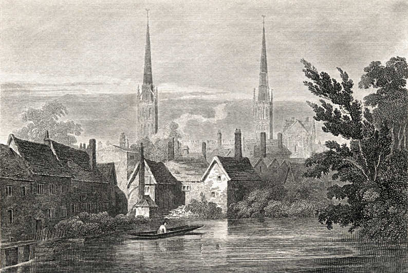
Ha, I'd forgotten that one Dutchman This older image is from almost the same spot but looking towards New Buildings and the spires.
|
|
Streets and Roads -
Hales Street
|
Osmiroid
UK
|
38 of 233
Thu 13th Oct 2016 1:00am
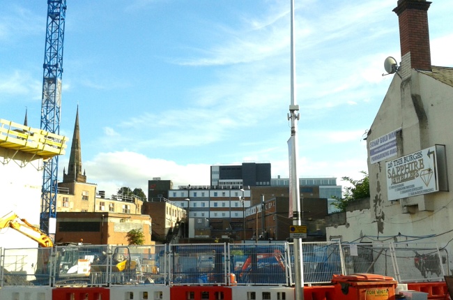
I took this picture, for the Pilgrims Rest location, and because I guessed it would be blocked off unfortunately.
 |
|
Streets and Roads -
Hales Street
|
Kaga simpson
Peacehaven, East Sussex
|
39 of 233
Thu 13th Oct 2016 10:34am
Heathite, I think your digger on post 32 is the end of the photo on post 55, Trinity Street thread. Between the pub and your digger was the Cafe Continental during the fifties, stood back level with the pub. In front of the cafe, that square was pale yellow slab stones. I think the cafe opened about 1951-2 time, it was a great meeting place for me. About 54 I had a personal talk with Jimmy Lynas on that square.
Where your digger is there was a makeshift greengrocery store on the bomb damaged building, and on that corner I had a photo taken with two attractive ladies, that showed the corner and the bomb damage clearly, but of course the photo disappeared when I got married.
Yes the Continental was always packed with teenagers and twenty year-olds. in fact I would say it was the most used cafe in Coventry during the fifties. |
|
Streets and Roads -
Hales Street
|
Midland Red
|
40 of 233
Fri 4th Nov 2016 12:19pm
The new development in Hales Street, viewed through The Whittle Arch 

|
|
Streets and Roads -
Hales Street
|
Osmiroid
UK
|
41 of 233
Fri 4th Nov 2016 2:53pm
On 30th Apr 2016 7:13am, Helen F said:
Ha, I'd forgotten that one Dutchman This older image is from almost the same spot but looking towards New Buildings and the spires.
Have any of the buildings been identified? If I am reading it correctly the light building to the right of the church would be something on Butcher Row? And the foreground interestingly pre the demolition for Trinity St.
|
|
Streets and Roads -
Hales Street
|
Helen F
Warrington
|
42 of 233
Fri 11th Nov 2016 12:41am
On 4th Nov 2016 2:53pm, Osmiroid said:
On 30th Apr 2016 7:13am, Helen F said:
Ha, I'd forgotten that one Dutchman This older image is from almost the same spot but looking towards New Buildings and the spires.
Have any of the buildings been identified? If I am reading it correctly the light building to the right of the church would be something on Butcher Row? And the foreground interestingly pre the demolition for Trinity St.
I know what most of them are. What you're looking at is the north end of the street called New Buildings, and looking south past it. A deceptive name because both that and New Street were erected just before the Civil War after some of the houses outside the wall were demolished to form a clear area so that the buildings weren't used as cover for enemy gunmen. On the left is the Priory mill and in front is the pond formed by the Sherbourne and the Radford Brook. The buildings curve round to just beyond that taller building with the flatter roof, where New Buildings goes off to the left and right and turns into Ironmongers. The tall building between Holy Trinity and the trees is the north tower of St Mary's before it was converted into the current form of the Blue Coat School.
|
|
Streets and Roads -
Hales Street
|
Osmiroid
UK
|
43 of 233
Fri 11th Nov 2016 1:28am
Brilliant info Helen, thanks  |
|
Streets and Roads -
Hales Street
|
Helen F
Warrington
|
44 of 233
Fri 11th Nov 2016 11:21am
It's a pleasure to be able to pass on what others have shared.
Incidentally, in and before Henry VIII's time the scene would have been very different. It would have been dominated by St Mary's, stretching from the towers on the right and then well off to the left. The towers would have been about twice the current height with steeple on top, shorter than Holy Trinity because the design wouldn't have supported something as impressive. The central tower would be just left of St Michael's I think and would also have been shortish. I'm not sure how much of the two churches' towers would have been visible over the main body of St Mary's. Between the viewpoint and the cathedral would have been the cloister and in front of that the kitchen and a few minor buildings.
The mill would have been there on the left. By the time the drawing was made it was probably a saw mill and may have been one back to at least the 1600s, although a lot of the water redirection was as old as the priory. The view to the right of the scene would have been largely uninterrupted until you got to the bottom of Palmer lane and to the right of that, Bishop Street and the grammar school. Behind and to the left was the Hales Street Gate, then known as the Priory Gate. The road was called Priory Lane at that point and (having now checked) had that name in 1750. While a few genuinely new buildings were slotted in between and behind the civil war era buildings as can be seen in the drawing, the bulk of the building done on the street was well off to the left, beyond Hill Top, where factory buildings were erected over the remains of the priory and its out buildings and stretched off to the more modern Priory Lane. There was a funny collection of very old buildings at the bridge that also included a saw mill but I'm not sure that was its original purpose. Beyond that there was Miller Lane and by the name of the road one assumes what was originally a flour mill. Beyond that there was the Earl's Mill at the end of Cox Street (formerly Earl's Mill Lane) and this was also a flour mill.
To the left of the scene is Pool Meadow and that was what you'd have seen till at least 1750 although the land was slowly drying. The original pools were part of the Priory and used as fish farms. The mill pond in the scene had gone by 1850 and later became the Hales Street market area. It was the point where large sections of the rivers started to be built over. |
|
Streets and Roads -
Hales Street
|
Annewiggy
Tamworth
|
45 of 233
Sun 20th Nov 2016 10:50am
Helen, I have just reread your post with reference to Earls Mill. To add a little more to the image Earls or Bastille Mill in 1659 consisted of 6 bays with corn mills for wheat and maslin (a mixture of rye & wheat or rye and oats). Robert Yardley had taken over the lease in 1641 and had to keep it in good repair. After his death John Yardley had the lease.
|
|
Streets and Roads -
Hales Street
|

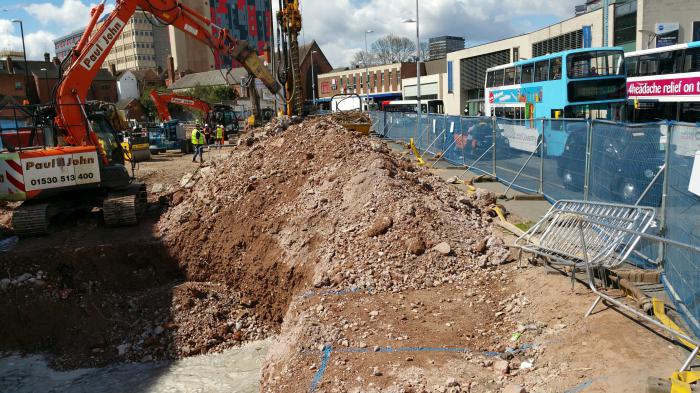
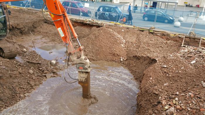
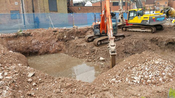 Regarding the hole, a contractor who was friendly enough to chat said they had contacted Severn Trent to remove the water. They declared it contaminated. They wanted a lot of money to treat it and dispose of it. So the builders have decided to apply for a license of their own to deal with the water. The contractor, a Coventry man, said they'd already tried removing the water with water tankers but as soon as they emptied the hole it filled up again.
The images are from successive days.
Regarding the hole, a contractor who was friendly enough to chat said they had contacted Severn Trent to remove the water. They declared it contaminated. They wanted a lot of money to treat it and dispose of it. So the builders have decided to apply for a license of their own to deal with the water. The contractor, a Coventry man, said they'd already tried removing the water with water tankers but as soon as they emptied the hole it filled up again.
The images are from successive days.