
|
belushi
coventry |
31 of 114
Sun 4th Apr 2021 8:06am
Interesting map Helen - I love maps that show field boundary detail. One of my pastimes is getting OS maps of the same place but in different years and then compare the changes - I can do this for hours with old Coventry maps.
I still think the name "River Cune" is a figment of somebody's imagination - perhaps the surveyor for William Hole's map asked the locals what the stream was called and they played a joke on him. Native Americans used to play this trick on the early white settlers - why not Native Coventrians?
|
| Local History and Heritage - Coventry's origins | |
|
Kaga simpson
Peacehaven, East Sussex Thread starter
|
32 of 114
Sun 4th Apr 2021 10:44am
Belushi,
I don't want to be rude to anyone, but I'm glad you said you like Helen's map, for I think it is historic on its own. It's exactly like the school maps we had a century ago, thick black lines of boundaries, that never were, boundaries were stones that got moved frequently.
Staffordshire, Shropshire and Cheshire, all had boundaries. As for the Welsh, they kept moving the boundary for almost 800 years. They were at war with Cheshire, it was a sparsely populated area and unproductive even before the Normans arrived, but salt mining was the main industry. There were two Saxon crosses in Sandbach market place in the 1050's, Knutsford's Ford (Cnut forded a stream) in the 11th century. The earthworks around Warwick Castle recall the battle to seize it for King William from Earl Edwin of Mercia.
River Sherborne, where does that come from? The village Sherborne and abbey are down in Dorset, the Bishop of Salisbury lived in the Abbey, the village is a thousand years old. I was stationed a few miles from it in 1945, the old stone prison of Shepton Mallet was close by (Domesday Book was kept there during WWII). |
| Local History and Heritage - Coventry's origins | |
|
belushi
coventry |
33 of 114
Sun 4th Apr 2021 2:08pm
Hello Kaga
According to the website House of Names "Sherbourne" is a toponymic surname that was originally derived from the Old English word "scir", meaning bright and "burna" meaning stream.
The surname Sherbourne was first found in Dorset where they held a family seat from early times at Sherborne, a market town that dates back to Saxon times. In 864, it was listed as Scireburnan and later as Scireburne in the Domesday Book.
Hence The Unicorn pub in Eastern Green was formerly called the Scireborne, even though the stream that runs alongside it is only a tributary of the River Sherbourne! |
| Local History and Heritage - Coventry's origins | |
|
Helen F
Warrington |
34 of 114
Sun 4th Apr 2021 8:13pm
I looked for the Cune in the Leet book1 and I couldn't find it but it's such a bad copy that at first I could only find one reference to the Sherbourne and I know that there are more than 1. However it also mention the Smithford Brook which I'm guessing was the Sherbourne as it ran under the Ram Bridge.
British History Online mentions the Cune as an alternative name for the Sherbourne. |
| Local History and Heritage - Coventry's origins | |
|
belushi
coventry |
35 of 114
Sun 4th Apr 2021 8:29pm
Thanks for the British History Online link Helen - that's the first time I've seen the Cune mentioned in a text. Even Mr Google couldn't locate it!
It did say that the Cune is an alternative name for the Sherbourne, not a different river William Hole's map showed. |
| Local History and Heritage - Coventry's origins | |
|
Kaga simpson
Peacehaven, East Sussex Thread starter
|
36 of 114
Mon 5th Apr 2021 10:21am
Belushi, hi!
Yes, I have read about the river Cune but can't think where.
Salford Priors, Salford. Leofva the Nun, formerly Leofric's wife, the Mill and Abbots Salford given by King Kenfred, King of Mercia.
The earthworks, hardly visible at Wawick Castle, recall the battle to seize it for King William from Earl Edwin of Mercia. King Offa, King of Mercia. King Swein, King of Mercia. King Godwin, King of Mercia.
The list is endless. |
| Local History and Heritage - Coventry's origins | |
|
Kaga simpson
Peacehaven, East Sussex Thread starter
|
37 of 114
Mon 5th Apr 2021 11:41am
Look I think we are all getting carried away here. The river Sherbourne was just the fields draining away by natural causes, but farmers built better ditches and brooks as time went on. Coventry was built on ten hills because of water, the Radford hill drained both ways, to the south the Sherbourne, to the north the Sowe. Completely different rivers, neither had anything to do with the canal.
The King family owned most of Radford in the 17th century, King Street in Victorian times was a very narrow and inconvenient thoroughfare and originally a walk outside the city walls. At the start of the 1800s it was known as "New Rents" from several buildings being erected there by the King family of Radford, who about 1675 brought the Radford water from the well near the farm to the King's Orchard, north of King Street, through leaden pipes into a large stone trough and to the malt house in Well Street. At the mouth of this sandstone well at Radford was a large piece of granite with initials of the King family.
The brooks and streams that ran off the north face of Radford hill formed the river Sowe and down to the valley of New Inn, across Longford park and to the water mill of Aldermans Green Road. |
| Local History and Heritage - Coventry's origins | |
|
belushi
coventry |
38 of 114
Mon 5th Apr 2021 1:12pm
Not getting carried away Kaga, just engaging in academic/intellectual debate.
I see your point about the drainage of Radford Hill going two ways, but, having lived in Radford for nearly half my life, I've never heard of Radford Hill.
We live and learn  |
| Local History and Heritage - Coventry's origins | |
|
Kaga simpson
Peacehaven, East Sussex Thread starter
|
39 of 114
Mon 5th Apr 2021 3:39pm
Belushi
I have a great advantage, Take away Pool Meadow, Trinity Street, IKEA, Broadgate House, The Precinct and many other buildings and you have my Coventry until I was ten years old. At that stage you could see at least a third more of the old city walls, the Cathedrals and a lot more before all these buildings arrived. The trams were the only transport at the beginning, not to Radford, but they had great difficulty with Bishop Street.
Coventry city gave me great interest in history, I walked its rivers, its fields and its market places, And then I lost it all in one night.
But that gave me a bigger incentive to find its past, then in 1945 I found the village of Sherborne and its great abbey, Cerne Abbey and the village and heard of the Domesday Book and a great more history. I travelled to places, including the Holy Land, and wonders never ceased. I have an official document that says I'm a true pilgrim signed by the Holy Sepulchre in Jerusalem. That opened doors for me.
During the fifties, I had a life that meant I could visit nearly all the great churches in Britain, historic sites, and with a wonderful memory, recall all.
The Sherbourne reached Radford hill, could only turn right, across the Burges, across Pool Meadow, then south again almost making Coventry an island.
PS Inside the Holy Sepulchre was this great rock, in the side of the rock a small hole, you bent down, crawled inside, about room for five people to stand, there was ledge of rock of about five wide, and that was Christ's tomb. |
| Local History and Heritage - Coventry's origins | |
|
belushi
coventry |
40 of 114
Mon 5th Apr 2021 6:28pm
Kaga - how I wish I could have lived through your times to see the history unfold that I can only read about. I have to rely on books and old maps and photos.
I can see from old maps how the River Sherbourne flows to the south of the hill that formed the original site of Coventry, though I wouldn't call that "Radford Hill". Does it have a name? Coventry Hill, perhaps? |
| Local History and Heritage - Coventry's origins | |
|
Annewiggy
Tamworth |
41 of 114
Tue 6th Apr 2021 6:29am
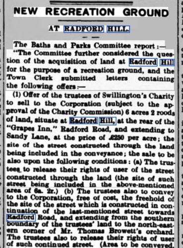
It would appear from this that Radford Hill is where the rec was built. The Grapes referred to would have been on that side of the road then. Later in the article it says that George Singer agrees to sell land on the south side of Swillington's land. The road leading to the rec to the houses that face the green is called Swillington Road, I always thought of that as "unadopted" as that is what the sign used to say! That road also leads to a footbridge over the railway. This article is 1908. There are houses being sold in 1936 and the area is still referred to as Radford Hill.
|
| Local History and Heritage - Coventry's origins | |
|
belushi
coventry |
42 of 114
Tue 6th Apr 2021 8:03am
Thanks for that Anne. That's the first time I've come across "Radford Hill"; growing up in that area it was always "the Rec". |
| Local History and Heritage - Coventry's origins | |
|
Annewiggy
Tamworth |
43 of 114
Tue 6th Apr 2021 9:08am
Yes, Belushi, I grew up in Poole Road and worked in Sandy Lane. It was always the rec and the one by St Nicholas The Common. The hill was always Lydgate Road but is always seemed to be Lydgate Hill locally and is what I would still call it. It was a good pull up there, so it makes sense that when there was not so much on it the area was Radford Hill. Where did you live ? |
| Local History and Heritage - Coventry's origins | |
|
belushi
coventry |
44 of 114
Tue 6th Apr 2021 9:39am
Hi Anne, I grew up in Middlemarch Road, and yes, for me it was (and still is) the Rec, the Common and Lydgate Hill.
When I was training to be a Geography teacher back in the mid-1970s I had to do a project on my local area, Radford, and I never came across any reference to Radford Hill.
Just looked at the 1887-89 OS 1:2500 map - no mention of Radford Hill. So where did the writer of the 1908 article get the idea it was called "Radford Hill"?
Was it local usage and not official? |
| Local History and Heritage - Coventry's origins | |
|
Annewiggy
Tamworth |
45 of 114
Tue 6th Apr 2021 10:12am
It appears to be official. There are lots of articles that refer to it as Radford Hill from the 19th century to at least 1936. Many of them are for land and property sales and also reports if various council meetings discussions. I have looked on old maps and can also not find any reference to it. Later maps just refer to it as recreation ground so perhaps it never had a name and the term rec just stuck. |
| Local History and Heritage - Coventry's origins | |

This is your first visit to my website today, thank you!
3,319,095Website & counter by Rob Orland © 2024
Load time: 40ms