heritage
Bedworth
|
31 of 192
Thu 19th Dec 2013 6:00pm
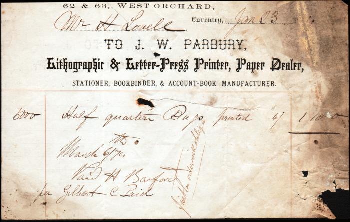
This maybe of interest, it was saved from a fire many years ago. Unfortunately the year is obscured by smoke damage.
 |
|
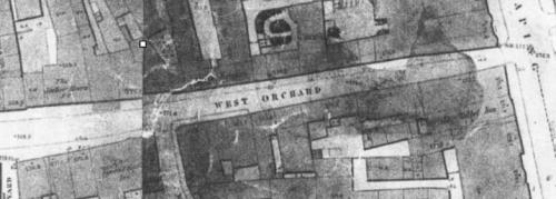
Streets and Roads -
West Orchard
|
Midland Red
|
32 of 192
Thu 19th Dec 2013 7:42pm
It says March 6/74 - could that be the date this January invoice was paid?  |
|
Streets and Roads -
West Orchard
|
Helen F
Warrington
Thread starter
|
33 of 192
Tue 3rd Feb 2015 10:55pm
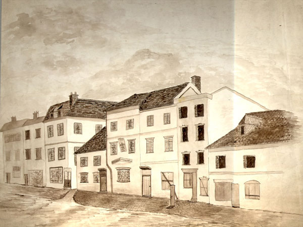
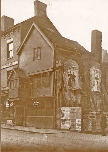
Previously when looking at West Orchard, I assumed that the Spread Eagle had always been where it was later situated on the Old Maps. However, the blurb on the back of this lithograph said that the Spread Eagle was originally next to the entrance to the market from West Orchard.

That might put this picture in a new light. The gap next door but one to the Spread Eagle could be the entrance to the market. What do you think?
|
|
Streets and Roads -
West Orchard
|
Annewiggy
Tamworth
|
34 of 192
Wed 4th Feb 2015 10:10am
Helen Don't know if this helps "The Character of Coventry" refers to the Spread Eagle as 12-25 West Orchard. Hewitt refers to this as being there in 1756. In 1862 it was rebuilt virtually on the same site and remained there until closure c1905.
I have just noticed that on your picture the 2 buildings on the right appear not to have the windows installed in the upstairs rooms and downstairs is boarded up, so does this mean that the whole street was rebuilt in the 1860's ? |
|
Streets and Roads -
West Orchard
|
|
Annewiggy
|
35 of 192
Wed 4th Feb 2015 10:36am
|
|
Helen F
Warrington
Thread starter
|
36 of 192
Wed 4th Feb 2015 10:59am
Thanks Anne, I've got the book and the picture I think you refer to is a Troughton. The watch house is the easy building to place and there are photos of that area before it was knocked down. The top picture, the lithograph, is dated 1886 though that may not be the date of the original drawing. The pub was supposedly removed in 1865. Maybe it moved from more westerly site and then back again?
As a road there are few decent photos and very little from before the new market building was constructed. Even Dr Troughton drew it mid demolition. There seems to have been loads of changes over the years to that road and I even realised recently that there had been another building next to the Talbot Inn where the road meets Cross Cheaping. I've even found a partial image of it. When I was doing this street before I had to stop because it was so mind boggling. The numbering on the street could be all over the place.
I've got a very grainy photo copy of the 1850 board of health map and it seems to show something followed by Eagle on the corner of the market street. Where the Spread Eagle was later located there is no pub marked at all. I had long assumed that the row of boarded houses in the second picture referred to the later location. I suppose the clue might be in how old that image is.
On second glance the buildings do look like they've had their windows removed. This could be prior to demolition for the new market and would add weight to the possibility they were up near the street leading to the market. Unfortunately some of the buildings near the other Spread Eagle location were also demolished, though not as systematically. Hmmm. |
|
Streets and Roads -
West Orchard
|
Helen F
Warrington
Thread starter
|
37 of 192
Wed 4th Feb 2015 11:23am
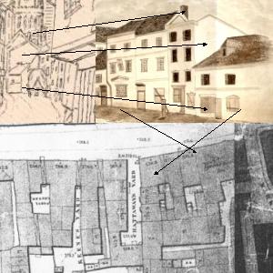
This is one possible image/location match. I know that it's something of a leap.
Ok, I've now reread the comment on the library pictures "Spread Eagle and adjoining buildings in West Orchard, taken down in 1865 to make room for new Market House." So this group is where I thought it was. The other Spread Eagle was too far down the road to be affected by the demolition of the market.
The number 12-25 would be the two locations. 12 is about right for the one next to the market street. Thanks Anne! It pays to ask for help  |
|
Streets and Roads -
West Orchard
|
|
Helen F
Thread starter
|
38 of 192
Wed 4th Feb 2015 12:22pm
|
|
morgana
the secret garden
|
39 of 192
Fri 26th Jun 2015 12:56pm
|
|
Streets and Roads -
West Orchard
|
NeilsYard
Coventry
|
40 of 192
Tue 8th Sep 2015 9:55pm
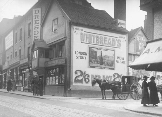
Apols if this has been seen before but I hadn't so thought it was worth sharing - West Orchard apparently:

|
|
Streets and Roads -
West Orchard
|
dutchman
Spon End
|
41 of 192
Tue 8th Sep 2015 10:04pm
Slightly earlier picture of the same corner:
|
|
Streets and Roads -
West Orchard
|
dutchman
Spon End
|
42 of 192
Tue 8th Sep 2015 10:08pm
Even earlier. It's the Old Talbot Inn of course on the corner of Cross Cheaping and West Orchard:
 |
|
Streets and Roads -
West Orchard
|
Helen F
Warrington
Thread starter
|
43 of 192
Tue 8th Sep 2015 10:54pm
Before I forget. The Talbot Inn wasn't originally on the corner of West Orchard, there was one more, very similar house connected to it. The image below shows the bottom of it. There is an early picture of the Talbot Inn in the library pictures that shows the Inn just after the corner house was demolished (which Dutchman has just posted). It has wooden props holding up the dividing wall. In the later photos above, you can see a new brick retaining wall.

The main body of the image is Cross Cheaping. The buildings on the left are rarely recorded as they can't be seen from Broadgate, where most of the images are recorded, because the thin 4 storey building sticks out from the others. There was an almost identical group of medieval gabled buildings on the other side which confused me at first. |
|
Streets and Roads -
West Orchard
|
NeilsYard
Coventry
|
44 of 192
Wed 9th Sep 2015 9:25pm
Thanks Helen - does that mean that the line of West Orchard altered slightly with the removal of the 'end' building?
I'm a little confused as the shot with the timber retaining supports - you can still see the line of the road and cobbles going underneath it? |
|
Streets and Roads -
West Orchard
|
Helen F
Warrington
Thread starter
|
45 of 192
Wed 9th Sep 2015 10:03pm
I noticed that Neil, perhaps the town fixed the road before the owners of the Talbot fixed the building? The 1850 map shows there was another building so it's not just a guess. At first I thought the second building in the sketch was the one on the other side of the road but when I noticed the evidence of another building in that early photo I realised the demolition can't have been that long before the photo. You can even see the slight upturn in the gable facia. It's gone by the 1888 fire insurance maps so you have a rough guide for demolition. It was all part of the market rebuild.
There was originally a straight line of buildings running beyond the little market street. The Spread Eagle was at the corner of that junction. I kept trying to fit the following image further down West Orchard, where the Spread Eagle had moved from and then moved back to. Only when I realised that the Spread Eagle moved about could I place the image at the market entrance where it belonged. The three buildings on the left are part of the demolished row that went up to Cross Cheaping. The 4th and 5th are part of the Spread Eagle. You can just see a funny little gap in the pavement that denoted the market street.
|
|
Streets and Roads -
West Orchard
|

