Helen F
Warrington
|
31 of 78
Wed 1st Apr 2015 3:13pm
They are the same houses Anne (nice drawing  ) and info says they're 1837 at the latest so they predate the factory. However, the 1850 map shows a block of houses missing between Bond Street and Riley Street which would push number 31 further west. My copy of the Board of Health maps stops there so I don't know what was westwards. That block may have been one of several between Gas Street and Riley Street that may have been demolished to make way for the factory. Does anyone know what number (if any) Hill House was? |
|
Streets and Roads -
Hill Street
|
Annewiggy
Tamworth
|
32 of 78
Wed 1st Apr 2015 3:55pm
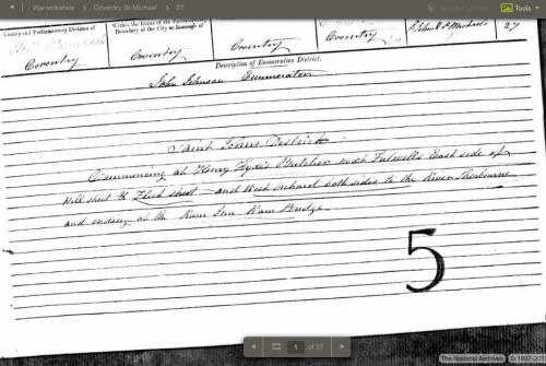
Hi Mickymatic and Helen. I have just looked at Elizabeth Moore on the 1851 census and the number 31 is not the number of the house but the enumerators schedule number so that will make it difficult to pinpoint the house. It does appear to be one south of Gas Street though. |
|
Streets and Roads -
Hill Street
|
Helen F
Warrington
|
33 of 78
Wed 1st Apr 2015 4:56pm
"enumerators schedule number"
The Board of Health map has funny numbers on each plot. The last on my map is 763.9 on the north side of the road and 265.0 on the south. Are they the same number style? |
|
Streets and Roads -
Hill Street
|
|
Annewiggy
|
34 of 78
Wed 1st Apr 2015 6:59pm
|
|
mickymatic
Market Deeping
|
35 of 78
Sun 5th Apr 2015 6:37pm
 Thanks to everybody who contributed, seems as if I may have opened a can of worms!
Thanks again, I'll keep an eye on your site
Regards
Mick
|
|
Streets and Roads -
Hill Street
|
mcsporran
Coventry & Cebu
|
36 of 78
Mon 6th Apr 2015 9:08pm
To find real house numbers you need to consult the street directories. The history centre have a good series of these but I'm not sure what year they start. |
|
Streets and Roads -
Hill Street
|
morgana
the secret garden
|
37 of 78
Mon 6th Apr 2015 9:12pm
Could have been the workhouse yard or Abbotts Gate or Spon Gate. I was just looking for 31 in the 1800s, perhaps if Micky knows what work his relation did it would help too. |
|
Streets and Roads -
Hill Street
|
mickymatic
Market Deeping
|
38 of 78
Tue 7th Apr 2015 9:10am
Thanks for the latest everybody!
The 1841 Census gives my 3x Gt Grandfather (William Moore) as a labourer.
Couple of observations:
The current 31 wasn't even built then.
Even if it was, it's too posh for a labourer!
The family were still in Hill Street in 1851, but William had died, the children were in the weaving and watch making trades.
Accepting that the current 31 is not my ancestral home.
It's the end wall that forms the left hand part of the building fascinates me.
Why was it left like that? Has it just been tidied up after bomb damage?
Thanks again everybody. |
|
Streets and Roads -
Hill Street
|
morgana
the secret garden
|
39 of 78
Tue 7th Apr 2015 10:20am
The workhouse was 66-68 Hill Street, the workhouse did use boys girls and adults too, to do weaving. The house in the link was a watchmaker's house. |
|
Streets and Roads -
Hill Street
|
Annewiggy
Tamworth
|
40 of 78
Tue 7th Apr 2015 11:46am
It is definitely going to be on the east side of Hill Street as per the header sheet of the 1851 census.
 |
|
Streets and Roads -
Hill Street
|
NeilsYard
Coventry
|
41 of 78
Sun 25th Sep 2016 3:56pm
Interesting to see up past the hospital - looks more like a muddy lane in this image!
Link to www.alamy.com
|
|
Streets and Roads -
Hill Street
|
NeilsYard
Coventry
|
42 of 78
Tue 22nd Aug 2017 4:23am
A tiny picture but worth it for the Mill.

|
|
Streets and Roads -
Hill Street
|
NeilsYard
Coventry
|
43 of 78
Sun 21st Jan 2018 10:01pm
|
|
Streets and Roads -
Hill Street
|
NeilsYard
Coventry
|
44 of 78
Fri 9th Mar 2018 10:28am
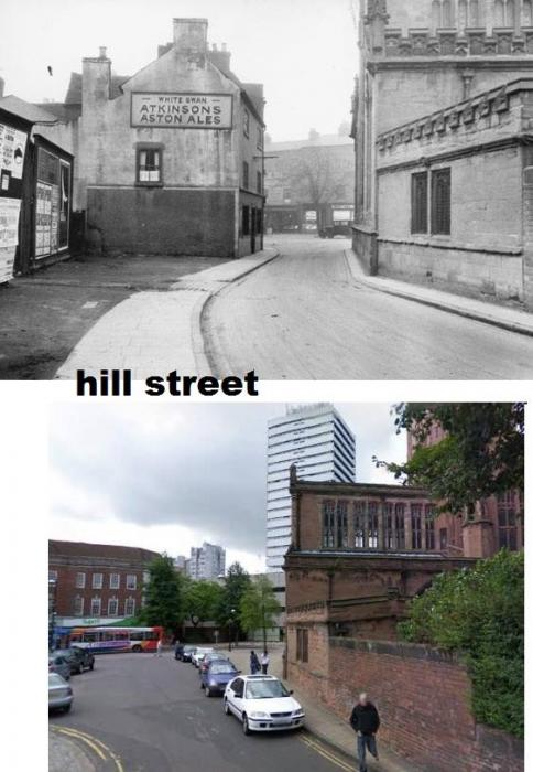
Thanks to Debbie Dean Nelson - I think that would have been the Newdigate Arms.
|
|
Streets and Roads -
Hill Street
|
Helen F
Warrington
|
45 of 78
Fri 9th Mar 2018 11:51am
I've never seen the Newdigate Arms on a map but I think it was the white building opposite the Bablake School gate. So yes, it was probably connected to the bricked up arch and to the right, in the photo looking up Hill Street. Britain From Above captured the area.
Zoom in to see the Newdigate Arms.
You can see the curved writing that often appeared on pub windows. Real Ale Rambles mentions the Newdigate in its section on the White Swan. It's on the left hand side, just beyond the jettied building. Small tip - pubs were often the building with a lamp outside. It was a warm symbol to lure people in.
The White Swan has a longer history and there is a matching sketch, to the two above, in the library pictures of the pub with the buildings closer to the photographer still intact. |
|
Streets and Roads -
Hill Street
|

