

|
Heathite
Coventry |
286 of 371
Wed 27th Nov 2019 1:33pm
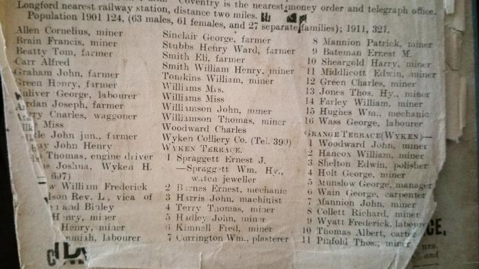
Hi, I don't know if these two images are clear enough but they are from the 1911 directory.
|
| Coventry Suburbs and Beyond - Wyken Slough | |
|
Helen F
Warrington |
287 of 371
Wed 27th Nov 2019 1:45pm
 Heathite.
Wyken Pool
This is the track between Aldermans Green and the Wyken Colliery. See the wiggly line of dots - probably the original water course. There is a smaller pool to the north of the road - could be Kaga's dad's handy work.
If you look at the landscape on the 1888 maps, a lot of the villages we now know well are very small villages. Some are connected to a hall but others are 'new' features connected to pits or railways or the canals. Go back another 100/150 years and many of those features vanish or dwindle to something not much bigger than a farm, eg Hawkesbury is named after Hawkesbury Hall. It gives its name to two roads, parts of the railway and the canal. The Hall itself looks Georgian and might not be very old at all. Not far away is Tolldish Hall which is half timbered, so could be where the builders of Hawkesbury Hall started out. Heathite.
Wyken Pool
This is the track between Aldermans Green and the Wyken Colliery. See the wiggly line of dots - probably the original water course. There is a smaller pool to the north of the road - could be Kaga's dad's handy work.
If you look at the landscape on the 1888 maps, a lot of the villages we now know well are very small villages. Some are connected to a hall but others are 'new' features connected to pits or railways or the canals. Go back another 100/150 years and many of those features vanish or dwindle to something not much bigger than a farm, eg Hawkesbury is named after Hawkesbury Hall. It gives its name to two roads, parts of the railway and the canal. The Hall itself looks Georgian and might not be very old at all. Not far away is Tolldish Hall which is half timbered, so could be where the builders of Hawkesbury Hall started out. |
| Coventry Suburbs and Beyond - Wyken Slough | |
|
Kaga simpson
Peacehaven, East Sussex |
288 of 371
Wed 27th Nov 2019 3:09pm
I have just spent an hour writing a post and lost it, tried hard to recover and failed.
Thanks for all your help, but it's of little help to be honest. Wyken was a village in Coventry, so addresses just belong there, although I would query the distance of Longford or Coventry station to the nearest railways.
Helen, no matter which way you walked from the 'slough' you walked uphill, except the stream's centuries old flow. To me slough meant marsh land and that's what it was until my uncle, somewhere around 1920, built a weir and made it a larger pool, for two reasons - one fishing, the other you will not find in any document or newspaper was for local men to recover and recuperate in, in quiet and peaceful surroundings, from their war traumas. This I believe was my endearment to the slough as a boy, as well as the wildlife.
Helen, most of the miners came out of their back doors and crossed what ever field to get to work. From Lentons Lane there were two tracks, because they crossed a bridge over the canal. From AG Road there were numerous, and they spread across the land like veins in your hand.
Helen, as a boy I knew every pit shaft, brickworks, in the area - it was my family's business domain for over century. An uncle and others drowned in the 'arm', I knew its workings, the acreage of every field, but ask the members on here of Woodway Lane, Deedmore Road, Potters Green, if they lived in Foleshill or Wyken. |
| Coventry Suburbs and Beyond - Wyken Slough | |
|
argon
New Milton |
289 of 371
Wed 27th Nov 2019 4:08pm
To date I have found two newspaper articles in the Coventry Times dated 1879 and 1889. Both say that in January of those years Wyken Slough was full of skaters more than even Quinton Pool. Presumably it was more than a boggy area at that time. |
| Coventry Suburbs and Beyond - Wyken Slough | |
|
Helen F
Warrington |
290 of 371
Wed 27th Nov 2019 6:56pm
I'm still not sure exactly what you're asking Kaga.
What places are called now is down to a mix of history and new names because the land is much more crowded. Town planners designate a name to an area and that's what it becomes. Wyken Slough is 2 miles from Wyken (I measured it). A distance that was easily within an estate size for a single family.
Caludon and Wyken
The link above explains the strange shape of the estate and how it came into ownership of the Craven family. "The estate passed to William Craven (who inherited the title of Baron Craven in 1764) remained the principal landowners in Wyken until after the First World War, when much of the parish was acquired by Coventry corporation for housing estates." The link gives you more than you need to know about the history of the area and the mining.
|
| Coventry Suburbs and Beyond - Wyken Slough | |
|
Kaga simpson
Peacehaven, East Sussex |
291 of 371
Thu 28th Nov 2019 1:22pm
Helen,
If I'm asking anything, it is for someone to show me where Wyken got anywhere near the collieries. Helen, look at any map of north Coventry in the last two centuries, draw a perimeter line from Walsgrave to Henley Road, Bell Green, Aldermans Green, Lentons Lane, Woodway Lane, back to Walsgrave. In that perimeter were all the shafts and workings but two, both streams that fed the slough, the slough itself and the outlet from the pool.
Now almost everyone working at those collieries lived in the lanes of that perimeter, and each walked away from the distant district of Wyken to get to work or go fishing in the slough, so it had nothing to do with Wyken district. I believe Binley shaft was nearer Wyken.
Two centuries ago Lord Craven was a very important man, so they named the Craven pit after him - as he was the major shareholder they named the firm after him, and the Craven pit closed in 1926/7.
Argon,
Two centuries ago the winters were longer and colder than now, and ice skating was a major sport - in every village the pond froze over and skating was the norm. What your papers didn't mention was that Longford Park, between the back gardens of Windmill Lane and the river, also got flooded and was a large lake, but only about three inches deep. It wasn't firm enough for real ice skates, but crowded with kids - but the miller was in control of the water, that changed the lake unexpectedly.
If I may ask you to make the same perimeter as above, call it a clock face, and near Jackers Road - make it twelve - there was a small ridge that ran from twelve to six that split the slough in two. This became a farm track, from where the stream came through AG Road at say three on the clock, to where the other stream joined it, one big reed bed with bog flowers. In winter this flooded right up to the back gardens of AG Road - I think they built the chapel opposite Jackers Road on stilts.
The two streams made a deep channel that ran almost the length of the slough of today, also full of reeds and water flowers, the inner bank of the river became the fishing arm about twelve feet across, beyond that was a deep hollow that filled with water in the winter and the overflow from the river that swept back into the hollow.
By placing a weir a little further on, the water was kept as a pool full time. I learnt to ice skate on the pool. |
| Coventry Suburbs and Beyond - Wyken Slough | |
|
argon
New Milton |
292 of 371
Thu 28th Nov 2019 3:17pm
Kaga,
I don't have your eyewitness view of the area, but in addition to the ice skating report there is one for 1915, or thereabouts, that tells of a schoolboy falling through the ice into 8ft of water and another boy jumping in to rescue him. We know that newspaper reports can exaggerate but I can only quote the report. Also in the papers during the Great War period there are reports of fishermen catching 18lb pike there. Now we know they exaggerate  Another report that surprised me was that the Foleshill Urban District Council was responsible for the upkeep of the paths by Wyken Slough at that time. Another report that surprised me was that the Foleshill Urban District Council was responsible for the upkeep of the paths by Wyken Slough at that time. |
| Coventry Suburbs and Beyond - Wyken Slough | |
|
Helen F
Warrington |
293 of 371
Thu 28th Nov 2019 5:42pm
Kaga "someone to show me where Wyken got anywhere near the collieries."
There is a difference between Wyken village and Wyken estate. The village was within the estate but not in the middle.
The Wyken estate and village are a lot older than the collieries and most of the places you list. A lot older than 200 years of maps as they go back to at least the 12th century. I reckon that "Henley Road, Bell Green, Aldermans Green, Lentons Lane, Woodway Lane," are all relatively new. Walsgrave is old (15th century?) but doesn't match Wyken for age. Foleshill is older than Wyken and dates back to at least the 11th century. So think of massive strips of land running out from Coventry - Foleshill estate, Caludon/Wyken estate and Walsgrave estate. They seem to stop just before Hawkesbury but, that may also be a modern feature. So the land on which the collieries eventually appeared had the name Wyken associated with it. Over the years, roads and communities appeared (including those that served the pits) but the title of the land still belonged to the Wyken estate. The name of the owners of the estate changed but the name of the estate didn't. However, on modern maps (including going back to 1888) councils gave areas a more local designation. Thus Aldermans Green, Bell Green etc were formed and then named. That didn't stop them being in the Wyken estate. So by your era, the Wyken estate had been filled with new villages and features, some with the Wyken name and some without.
To see Wyken on a map and not those other places, you would need to find some very old tithe maps. You can repeat the same idea to the east, west and south of Coventry. Each area divided into big estates that were then subsequently subdivided. Go back far enough and there would have probably only been one estate belonging to Godiva and Leofric. |
| Coventry Suburbs and Beyond - Wyken Slough | |
|
Kaga simpson
Peacehaven, East Sussex |
294 of 371
Fri 29th Nov 2019 1:09pm
Helen
So why does McGrory say the Foleshill Road and district goes back to Roman times, all of the place-names associated with Roman times.
He says Wyken was first mentioned in the 12th century, the first tenants on the estate were in the 12th century and it's his history that confuses me.
Yes, it is confusing - smack in the middle of those mine shafts two cottages, that JW of this forum knew were called Wyken Cottages, a few yards away a ten year old boy was drowned, Joseph Oldham, D Oldham of this forum (rel), inquest Boat Inn, Sowe Common, Foleshill 1891. On the opposite side to those cottages was Potters Green church of Foleshill, next to Wyken Craven pit, but actually in Foleshill. I could go on but this is of no interest to you, this local stuff!
But I do need your expertise in that sketch on a different topic. |
| Coventry Suburbs and Beyond - Wyken Slough | |
|
Helen F
Warrington |
295 of 371
Fri 29th Nov 2019 8:44pm
Your knowledge of your and your parents' era is very important Kaga and doesn't really disagree with the older facts.
What you remember is based on hundreds of years of existing development, rapid population and industrial growth. To understand it, you have to dial time backwards and see how empty the land was. A lot of land could come under the same name because there was nothing else of significance in the area. That land was owned by a limited number of people. Even villages were owned by the landowner. |
| Coventry Suburbs and Beyond - Wyken Slough | |
|
Kaga simpson
Peacehaven, East Sussex |
296 of 371
Sat 30th Nov 2019 2:14pm
Helen - now I'm going to get a lot of flack!
It's not about me, the local historian in his book said two small points, like two small circles about three inches apart were the 'slough', the other 'Craven mine' was in Wyken. The land between, he says is Foleshill Manor Farm (now Wood End) to the north he says was Victoria Mine was in Foleshill, to the west was AG Road, and the old mill was in Foleshill, to the south Walsgrave-on-Sowe - so how did those to little tiny places be placed in Wyken? |
| Coventry Suburbs and Beyond - Wyken Slough | |
|
Not Local
Bedworth |
297 of 371
Sat 30th Nov 2019 8:10pm
Kaga - It is all very confusing but to my mind there can be several different descriptions for what might be the same area.
Wyken was an old feudal estate which covered a very large area. It may well have covered what we now know as Wyken, but it also stretched over a far wider area.
Foleshill and Walsgrave-on-Sowe are more modern descriptions of an area or a village within a political boundary. They eventually were swallowed up into the city but retained their names as districts of Coventry.
Then there are parish boundaries which were set by the Church of England and which were changed as the city grew and more churches were built to cater for the growing population - St Thomas at Longford is probably a good example of that.
To complicate things even further we have the modern boundaries, there are signs saying 'Welcome to Foleshill' spread far and wide in places that would never have been identified as Foleshill as little as 40 years ago. Sometimes things are changed to reflect modern thinking - Foleshill Park was next to the Dunlop but now it is called Holbrooks Park. Other features retain their old names from generations ago and give us all something to exercise our minds on.
|
| Coventry Suburbs and Beyond - Wyken Slough | |
|
Helen F
Warrington |
298 of 371
Sat 30th Nov 2019 8:35pm
Kaga, you really need to look at the features on the full map. Boundaries are often streams and rivers rather than roads. They don't follow compass directions. They wiggle round places rather than go through. The short answer to your query is - the boundaries aren't straight so 2 places might be directly in line with each other but be different sides of the boundary. Sometimes a field may be assigned to the 'wrong side' because at some point there was an agreement about where the boundaries lay. Modern developments may not respect the old boundaries at all, confusing things further.
The following route is the most logical route for the Wyken boundary starting at the top left, just north of Wyken Pool, on the Hawkesbury Road and travelling anti-clockwise.
The division between Foleshill and Wyken estates at the north end was the stream that runs into the Wyken Pool. Victoria Farm was to the west of that stream, so it was the Foleshill side. The slough is the scrubby bit to the east of the pool (ie on the Wyken side), and this was why it was called Wyken Slough. I'm guessing that the pool was named after that, not the other way round as I'd thought. On the map it's clear that the boundary line through the pool wiggles about, which indicates that it was originally a stream, not a pool. If it had been a pool when the boundary was created, it would have either bisected the pool or skirted one side or the other. Further south the boundary stream joins up with the River Sowe. In respect of this boundary, Foleshill Manor Farm is to the west. Foleshill Corn Mill is to the west. Alderman's Green is to the west. Courthouse Green is to the west. Wood End is on the east, Wyken side. I think that Henley Green is also on the east.
Halfway down the Wyken estate (just below Henley Green), the Sowe crosses from Wyken's west boundary with Foleshill to its east boundary with Walsgrave. There are 3 features to the south of that crossover on the west boundary - Wyken Green, Wyken Grange and Wyken House in a rough line south from Henley Green. The Wyken/Foleshill boundary would probably have been to the west of these properties. The land to the south of Wyken House is Stoke.
Following the Stoke boundary to the east you pass Stoke house to the south before arriving at the Sowe again. The western side of the river heading north is Wyken's boundary.
Study the map.
Wyken on Old Maps
At the south east of the Wyken estate I don't know whether Hungerley Hall Farm and Hungerley Farm are in or out of Wyken, but Caludon Castle is inside Wyken. The boundary runs to the west of Walsgrave up the river Sowe. The Sowe Mill in on the Walsgrave side of the boundary. Just before the Sowe heads west, near the Craven Colliery, the boundary probably heads north along a stream. I can't tell exactly what route it took north of the Craven Colliery but Wyken Colliery Farm is obviously on the Wyken side but I'm not sure about Potters Green just to the east of it. There is a stream that runs north from Potter's Green passing Alexandra Colliery to the west (inside Wyken). This stream comes to an offshoot of the Oxford Canal that may be an original route of the stream. That waving line puts the brickworks on the east of the Wyken boundary but the Wyken Colliery inside the boundary. Lenton's Lane would be on the Walsgrave side. The canal then heads roughly northwest to where it crosses the Hawkesbury Lane. That road crosses the canal and the original stream I started at, which may be Wyken's most northerly boundary or that boundary might be a bit further north where the stream and the canal converge just south of Hawkesbury.
|
| Coventry Suburbs and Beyond - Wyken Slough | |
|
Dreamtime
Perth Western Australia |
299 of 371
Sun 1st Dec 2019 4:30am
Helen, you must have the patience of Job. I wish I was a drone (think of the benefits)  |
| Coventry Suburbs and Beyond - Wyken Slough | |
|
Rob Orland
Historic Coventry |
300 of 371
Sun 1st Dec 2019 10:31am
Helen - I need to adjust the forum "thumbs up" feature to allow me to put a hundred of them for your amazingly detailed post! Like Dreamtime said, you seem to have almost inexhaustible patience!
Talking of the Craven/Wyken boundaries Kaga, this Wyken area map scan on Historic Coventry seems to show the boundary (dotted line) skirting around to the north and east of Craven Colliery, like Helen (and David McGrory) mentioned, so even though it is very close to Walsgrave, it did indeed come within Wyken's "jurisdiction".
As Helen and others clearly pointed out, boundaries are very strange wiggly things, with long forgotten historical relevance. I live just 30 yards or so from the original Wyken House (sadly long gone), which was only about 300 yards from Stoke St. Michael's church - supposedly the centre of Stoke - so I've always regarded us as being Stoke folk. However, we're actually just within the ancient parish boundary of Wyken - even though we're nearly a mile from St. Mary's church. Wyken was really huge! |
| Coventry Suburbs and Beyond - Wyken Slough | |

Website & counter by Rob Orland © 2024
Load time: 210ms