Midland Red
|
196 of 229
Thu 28th Jan 2021 3:15pm
Coventry Herald 1940
|
|
Town Planning and Development -
River Sherbourne
|
Helen F
Warrington
|
197 of 229
Thu 25th Feb 2021 9:37am
On 20th Oct 2015 1:36am, NeilsYard said:
Heres a great view of the works. Makes the land outside of the ring road around Vignoles Bridge seem very open.
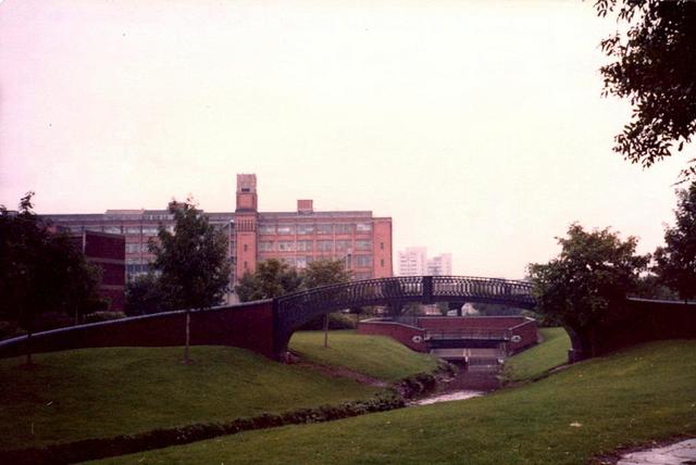
I've only just realised that the bridge sits over a new bit of the river. Originally it curved over to the right and then back again. |
|
Town Planning and Development -
River Sherbourne
|
NeilsYard
Coventry
|
198 of 229
Thu 25th Mar 2021 3:09pm
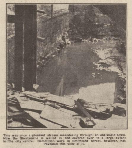
Rich Edward has just posted this interesting river image on FB from 1956 from Priory Street.
|
|
Town Planning and Development -
River Sherbourne
|
scrutiny
coventry
|
199 of 229
Thu 25th Mar 2021 3:24pm
Wow, part of my playground as a kid. If you enlarge the pic you can make out the dam which you would lower into the river to raise the water level for fire engines to use. Just in front are two concrete blocks with slots in. Planks could be dropped into the slots also to dam the river.
Pic taken on a bad day I think. When there was heavy rain the Sherbourne would be a raging torrent. It would be a couple of days before we could play in it again but all the rubbish would have washed away  |
|
Town Planning and Development -
River Sherbourne
|
lindatee2002
Virginia USA
|
200 of 229
Fri 26th Mar 2021 12:30am
On 25th Feb 2021 9:37am, Helen F said:
On 20th Oct 2015 1:36am, NeilsYard said:
Heres a great view of the works. Makes the land outside of the ring road around Vignoles Bridge seem very open.
I've only just realised that the bridge sits over a new bit of the river. Originally it curved over to the right and then back again.
When was this photo taken? I've never seen this view of the river. |
|
Town Planning and Development -
River Sherbourne
|
Wearethemods
Aberdeenshire
|
201 of 229
Fri 26th Mar 2021 9:58am
I would guess 1970/71 |
|
Town Planning and Development -
River Sherbourne
|
lindatee2002
Virginia USA
|
202 of 229
Fri 26th Mar 2021 10:08pm
Thanks for that information. Where would I go to see that bridge or am I too late? |
|
Town Planning and Development -
River Sherbourne
|
Midland Red
|
203 of 229
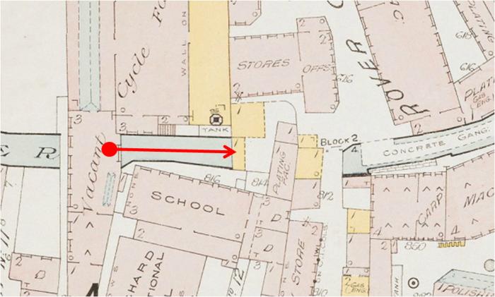
Sat 27th Mar 2021 8:13am
|
|
Town Planning and Development -
River Sherbourne
|
lindatee2002
Virginia USA
|
204 of 229
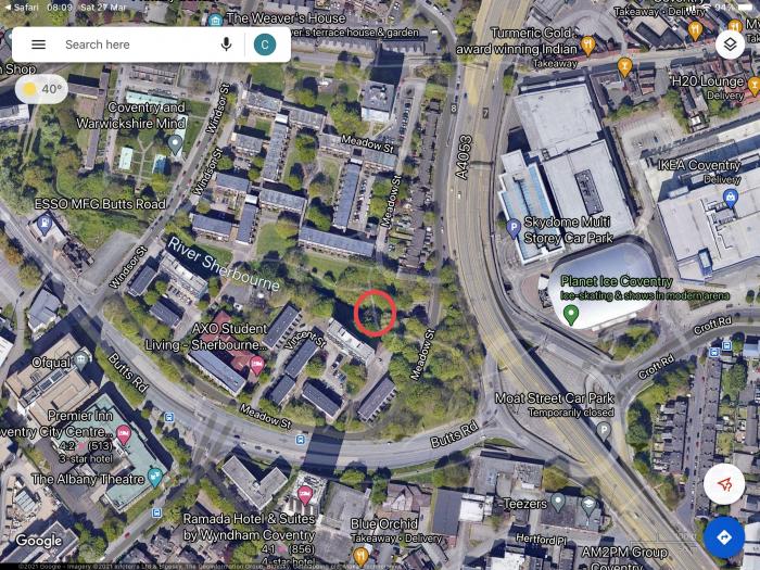
Sat 27th Mar 2021 2:44pm
Thank you, Midland Red, for the map. I hope to be able to visit Cov. at the end of the year and I'll make an effort to go to the bridge.
When we was using the buses in the Cov. area in the 60's we called them the Midland Dred as we could never organize ourselves with their timing. |
|
Town Planning and Development -
River Sherbourne
|
NeilsYard
Coventry
|
205 of 229
Thu 28th Oct 2021 10:13am
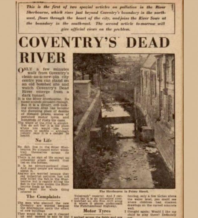
During a flick through my photo database I came back over this one - I can't recall if I've added it before or where I sourced it from however is it possible this is Ram Bridge? It doesn't actually look wide enough so possibly mislabelled - Helen what do you think? It may be the Sherbourne Crossing on Priory Street?
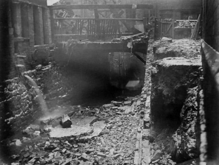
|
|
Town Planning and Development -
River Sherbourne
|
Annewiggy
Tamworth
|
206 of 229
Thu 28th Oct 2021 12:05pm
Someone has it on Pinterest and it says 'Flood, West Orchard 1900'. Don't know where they got the information from though! |
|
Town Planning and Development -
River Sherbourne
|
Helen F
Warrington
|
207 of 229
Thu 28th Oct 2021 12:10pm
I was thinking along those lines Anne. There were some little linking bridges between factories on the north side of West Orchard. It's not big enough to be one of the proper road bridges. |
|
Town Planning and Development -
River Sherbourne
|
Helen F
Warrington
|
208 of 229
Thu 28th Oct 2021 2:51pm
I'm thinking it's this view. The narrow bridge is much older than the building spanning the river behind it. But I'm far from sure. The photographer was possibly on the other side of the river to the dot.
 |
|
Town Planning and Development -
River Sherbourne
|
Annewiggy
Tamworth
|
209 of 229
Thu 28th Oct 2021 3:56pm
Hi Helen. It is very difficult, I had been wondering if it was a little further along, in between the old Albion Works which could be the building on the left and the school on the right. On the far right hand side of the picture the shape of the area does get a bit wider towards the bottom of Neil's picture. There is a little gate at the end as well, gate to the school? It says in the newspaper that the chapel a little further along was under water and the bridge was damaged. If you look at old maps online there is a fire map for 1897 which shows something across the river but I don't know if it is a bridge or a building. Just a suggestion. I bow to your greater knowledge of the area but without pictures of the street at the time it is difficult  |
|
Town Planning and Development -
River Sherbourne
|
Helen F
Warrington
|
210 of 229
Thu 28th Oct 2021 4:16pm
I was thinking it didn't look big enough to be that collection over the river but looking again yes, it could be. The wooden 'bridge' could be the remains of a one storey wooden building as in the fire map. I think you're right Anne. The photographer could have been looking out of the previous building.
|
|
Town Planning and Development -
River Sherbourne
|