 This is how we plan things in Cov.
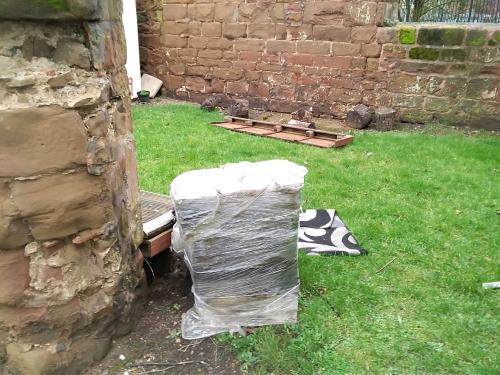
 The skip.
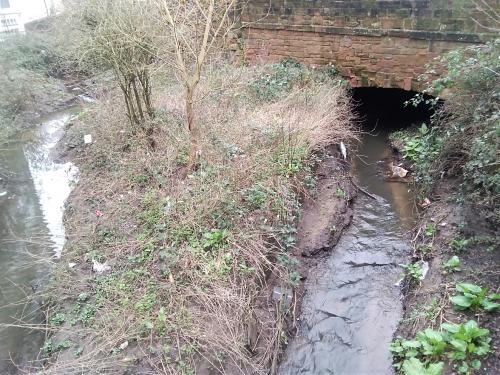
 Upstream, the sad remains of the wildlife haven behind my nan's little shop.
 Coventry design and modification?
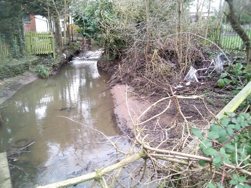
 The back brook!

|
moriarty
allesley park coventry |
181 of 229
Sun 17th Jan 2021 1:08pm
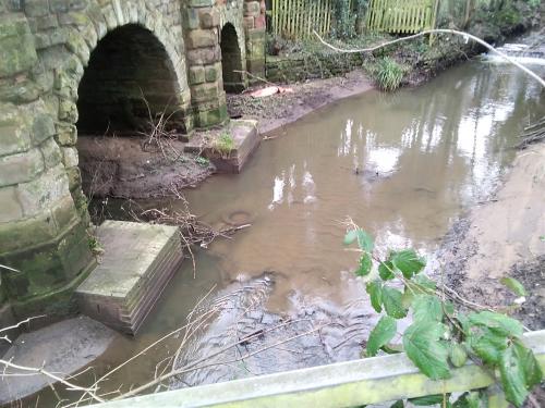
When I was a child my gran owned a tiny shop which backed onto the Sherbourne at Spon End.
The area then suffered much poverty, had large families and a rabbit warren of courts, raggedy children played happily on land next to the Old Dyers Arms, their hair and faces unwashed, the younger ones with snotty noses and bare feet. I wasn't allowed to play!
There was much pride in belonging to Spon, and wives would sew a button on the "traditional flat caps" to denote this.
St Christopher's Chapel was still occupied by a little old lady, an amazing higgledy piggledy structure, until the council spotted it.
The Sherbourne, enclosed and private, sparkling clear with shiny stones and sticklebacks, the pumphouse gardens full of mature trees, an unexpected wildlife haven
How different today! Gone are the trees, the greasy grey slick full of tyres, trollies and detritus.
The massive council-built tower block, unbelievably its giant footprint blocking the river course, a storm drain emptying into the stagnant pool below
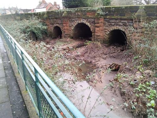
The once picturesque bridge, now little more than an inconvenience or folly. St Christopher's Chapel now a convenient skip for the locals' larger discarded items, and yet, although the arches are compromised, the brook flows freely.
But look. There, a few metres away, hidden in the bridge structure, is another arch! How odd! Then, I realise this is the source of the "back brook". On early maps the sluice for the mill behind Rotherham's. Obviously this mill was important for this to have such an elaborate control included within Spon Bridge.
The hidden arch!
This is how we plan things in Cov.
The skip.
Upstream, the sad remains of the wildlife haven behind my nan's little shop.
Coventry design and modification?
The back brook!
|
| Town Planning and Development - River Sherbourne | |
|
Helen F
Warrington |
182 of 229
Wed 20th Jan 2021 2:45pm
Nice photos moriarty, the rubbish notwithstanding  There are very few photos looking at the north side of the bridge. The area used to be quite bright as the trees and briars are a new feature, never mind the tower block. This has encouraged the moss on the stones and leaf litter in the river. I don't know if the silt in the river is a modern or weather related feature but looking at old sketches there did seem to be river pebbles visible where now it seems to be just mud.
The 4th arch is relatively modern but there was a smaller outflow there in older pictures. I think it drains the north side of the causeway rather than take some of the flow of the Sherbourne. At east one stream has vanished from where it joined the Sherbourne near the old Water Works. The bridge is located on a very odd stretch of the river, where it widens out considerably compared to the body of the river north and south of the bridge. The area would have originally been a ford and the reduction of depth and speed would have enabled crossing. The river was naturally shaped by meanders and even though man has confined the river with stone and brick, it still wants to cut its own path. The bridge has been regularly strengthened as the water wears away the supports. While the concrete slabs are brutal, they stop further erosion. It might be English Heritage that demands a modern look to the repairs, so that they are not mistaken for the original stonework... or maybe it's just stronger. There are very few photos looking at the north side of the bridge. The area used to be quite bright as the trees and briars are a new feature, never mind the tower block. This has encouraged the moss on the stones and leaf litter in the river. I don't know if the silt in the river is a modern or weather related feature but looking at old sketches there did seem to be river pebbles visible where now it seems to be just mud.
The 4th arch is relatively modern but there was a smaller outflow there in older pictures. I think it drains the north side of the causeway rather than take some of the flow of the Sherbourne. At east one stream has vanished from where it joined the Sherbourne near the old Water Works. The bridge is located on a very odd stretch of the river, where it widens out considerably compared to the body of the river north and south of the bridge. The area would have originally been a ford and the reduction of depth and speed would have enabled crossing. The river was naturally shaped by meanders and even though man has confined the river with stone and brick, it still wants to cut its own path. The bridge has been regularly strengthened as the water wears away the supports. While the concrete slabs are brutal, they stop further erosion. It might be English Heritage that demands a modern look to the repairs, so that they are not mistaken for the original stonework... or maybe it's just stronger. |
| Town Planning and Development - River Sherbourne | |
|
moriarty
allesley park coventry |
183 of 229
Thu 21st Jan 2021 7:12am
Thanks for your input, Helen, much appreciated.
Very interesting theory, but you've failed to convince me this time, I'm sticking with my theory, it's much neater and stacks up a lot better.
I can list why it you like, but it would be the same as "watching paint dry" for everyone else!
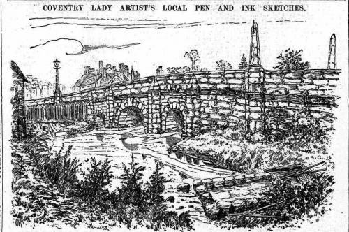
I'm including a sketch of the pump house gardens, it shows the mill at Spon. Unfortunately the council didn't manage to put their concrete blocks onto the sandstone viaduct in time.
It was sketched from the roof of the pumphouse, unfortunately it doesn't show Spon bridge but does show some type of early garden or park!
 It's quite difficult to work out if there are two river courses in the sketch. There might be.
|
| Town Planning and Development - River Sherbourne | |
|
Helen F
Warrington |
184 of 229
Thu 21st Jan 2021 10:25am
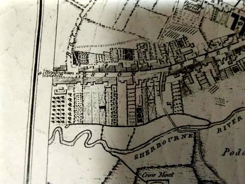
Yes, I was surprised at the garden when I saw it on the map. The Victorians made utility look pretty. Your thought that there might be a river course from the right is correct. It joins a flow from the mill and then heads off to the left, towards the bridge. The watercourses are partly manmade in the area and it's hard to know where the river originally ran.
Map of Spon End
If you look at the map, you can see the view in your sketch. Not on that map, is another stream that ran between the school and the river, along the eastern embankment for the Water Works. It does show a small stream emerging from the 4th arch in the causeway but it's not the main river course and it joins the Sherbourne. It's not obvious where it's coming from. It's not there in an earlier map, which is far more detailed. |
| Town Planning and Development - River Sherbourne | |
|
moriarty
allesley park coventry |
185 of 229
Thu 21st Jan 2021 11:47am
Just for completeness, the photos are not new, 2019. The area is a lot worse than it looks on them. Perhaps it's been cleaned up now!
I spent quite a while grubbing about amongst used needles and unmentionables. There is only one 4th arch on the down stream side, none on the upside. There is a tunnel at 45 degrees from the 4th arch to the 3rd arch of the bridge which means it goes away from the causeway.
There was banking and quite a steep incline opposite my gran's little shop, all that seems to have been bulldozed flat to build the estate over there so perhaps that is where the soil gets washed in.
You can see when the river level rises it starts to go through the 3 arches of course but normally virtually nothing goes through. |
| Town Planning and Development - River Sherbourne | |
|
Helen F
Warrington |
186 of 229
Thu 21st Jan 2021 1:11pm
All good information, thanks.
I had a feeling that I'd seen a picture of the causeway in ruins and I found them on eBay (caution, buying these won't confer ownership of copyright) - Some pictures of the bridge and causeway in 1972
So the new arch probably stems from that. The water may be taken from the Sherbourne through a duct pipe on the north side, but wherever it's coming from, the river is trying to go round the bridge, through the causeway. The bridge itself only dates back to the demolition of the Spon Gate in 1771, from which the bridge was built. |
| Town Planning and Development - River Sherbourne | |
|
moriarty
allesley park coventry |
187 of 229
Thu 21st Jan 2021 3:47pm
Thanks Helen,
That's more or less proved that it was installed in 1972.
So you don't think the back brook ever went right back to the bridge, so it wasn't a sluice control for the mill. Was the mill even water powered?
So why was the back brook there and why was the mill adjacent to it? Am I really in Coventry!!!!!!
Very interesting postcards once you get the orientation. 2nd one down you can see the storm drain installation (the thing that looks like a cannon in the centre).
So they built the tower block over the river course and then had problems with water backup so they created a 45 degree pipe hidden in the brickwork to elevate or ease the problem!
In the process, pulled the bridge to bits!
You can't actually see the work to install the pipe but the amount of destruction is shocking, it's practically a new bridge from 1972.
I wonder why they even bothered to rebuild it considering it has no real practical use.
|
| Town Planning and Development - River Sherbourne | |
|
Helen F
Warrington |
188 of 229
Thu 21st Jan 2021 5:53pm
I don't think that the fourth arch supplied the mills along the Back Brook but the water for the Back Brook does seem to emerge out of nowhere. * The Spon Mill was originally water powered. It was called Jordan's Mill and there's sketch in Florence Weston's collection and various places on the internet. Robthu reminded me of this excellent resource on the rivers and mills of Coventry.
Must see site about the River Sherbourne
I think the river goes round the tower block but it can't easy be seen. Although building the block meant that the river line was then fixed and the angles couldn't be softened. I think the bridge direction caused the problem with the water. The supports aren't in line with the waterflow. Not normally a problem but when it floods...
* The Back Brook is a bit of a mystery all of its own. Logically it's a mill race coming off one of the Sherbourne meanders (but not as far back as the bridge) and heads towards Crow Lane and beyond. But in both the 1749 map and the detailed 1850 map it seems to appear from a very small pool. 1) Was it once fed from the Sherbourne from a meander that is on the 1749 map but had been removed by 1850? 2) Was it fed from the river but it was a culvert even before 1749? 3) Was it an old stream bed from the north that had been culverted, including even drainage from Spon Street and Barrs Lane? It could be a bit of all 3. The wiggly nature of the Back Brook suggests a very old line, which suggests that it may have even be natural. There was a spring and a well in the areas where it starts. |
| Town Planning and Development - River Sherbourne | |
|
moriarty
allesley park coventry |
189 of 229
Sat 23rd Jan 2021 3:27pm
Helen, thanks for the reference to Colin's Sherbourne site, a really good read.
I think maybe the owners of the mills need clarification. He mentions Spon End mill as Jordans mill and Rotherham's mill as Crow corn mill
I see he has a print of Spon End bridge (couldn't upload) 1600 pack horse bridge - which side is that taken from, upstream or down?
Just cannot line up all the ducks. However if you look at it reverse image in a mirror the bridge is correct to the chapel and also the first house after the bridge (looking downstream).
Also I asked before Crow corn mill (not as I called it Spon mill), do you think it was water powered?
|
| Town Planning and Development - River Sherbourne | |
|
Helen F
Warrington |
190 of 229
Sat 23rd Jan 2021 7:04pm
I've struggled with that image of the chapel and the packhorse bridge, wondering how genuine it is (probably painted looking roughly from the south east). Note the lack of a roof or windows for the chapel. I have an image from the Aylesford Collection and it shows a roof and the modern bridge, which dates it to after 1772. It doesn't show the doors in the end wall and it looks a lot more like a chapel with window tracery but those were already blocked up. By, at the latest, 1819 the end window has the doors with steps up to them and the main door has been walled up. So unless it's a complete fake, the packhorse bridge picture would be either pre 1772 or painted from memory. The lack of roof is not a deal breaker as the poor building has not been loved over the years. Perhaps they repaired the building in the same era they built the bridge?
In my opinion the ford, the pack horse bridge and the current bridge are not necessarily in the same places and the river may have shifted slightly too. Don't be persuaded by the size of the embankments. From early photos to today, we can see how fast the silt builds up and the plants take over. By my reasoning, they wouldn't have built the new bridge over the ford because they still needed it, although they may have narrowed it. All/most of the buildings on the south east side of the street up to Sherbourne Street were new, so no need to think that they were in the way of an earlier track. I do know that there was a track from the west end of the bridge down to the water. A track of a similar gradient could easily have run up the other side. The packhorse bridge could have been either north or south of the ford but the path to the ford could have continued along the south bank until the river narrows and a small bridge could span the narrower but deeper stretch. That option fits the picture of it best but not perfectly. Basically, it's complicated.
From British History Online - CROW MILL, first mentioned in the early 13th century, lay on the Crow Mill Stream or Back Brook, an arm of the Sherbourne running north of Crow Lane Bridge. By the late 13th century it belonged to the priory and was leased by the priory cellarer in 1411. The mill was probably a corn-mill since the occupier in 1512 was a baker.
The most logical location was where Crow Lane meets the Back Brook. Some of Coventry's mills were converted to steam but I don't know that Crow Mill survived that long. It looks like the building was still there in 1749 but had gone by 1850 and the area was a large silk dye works.
|
| Town Planning and Development - River Sherbourne | |
|
moriarty
allesley park coventry |
191 of 229
Sun 24th Jan 2021 12:43pm
Have you got a picture of the packhorse bridge, Helen? Could you put it on here and could you flip it over for me?
Of course I would have thought it to be an engraving, not a painting, most drawings were engravings in books back then.
I had no idea there was a packhorse bridge there first! Just a crossing I thought. Also I would love to see the photo of the original 4th arch you mentioned you had before the council utilised it for flood problems!
I imagine that's how they got permission to jackhammer the bridge to rubble in that postcard photo. There was an existing tunnel through the bridge. It would be interesting to access the 1972 planning permissions, I bet they did it undercover when they built the tower block.
The engraving of the packhorse bridge is so like the 2nd, 1767 bridge! You can see it was just tarted up so it seems it was in the same place so there was no inconvenience necessary. |
| Town Planning and Development - River Sherbourne | |
|
Helen F
Warrington |
192 of 229
Sun 24th Jan 2021 5:36pm
The image I've got in my sorted records is the same as the one at Colin's Cornucopia and is a print screen from somewhere or copied from Google image search. Type in "spon chapel coventry packhorse" and you will see it within the first few rows. In my unsorted collection I've a feeling I've got a colour version but it would take me ages to find it. As you say the black and white one might be an engraving and maybe the colour one is just a hand coloured version but it's very poor quality for an engraving as they tend to be designed to be clear when reproduced. Ok it might be a bad photocopy of an engraving but I can't see lines. The foreground is very dark, almost impossible to see. Flipping makes the bridge even further east than the un flipped image which doesn't fit the map. The picture has the chapel at this orientation. There was no matching half timber building on the other side of the chapel as far back as I can see, so it doesn't need to be flipped.
 The 1819 version at the Herbert.
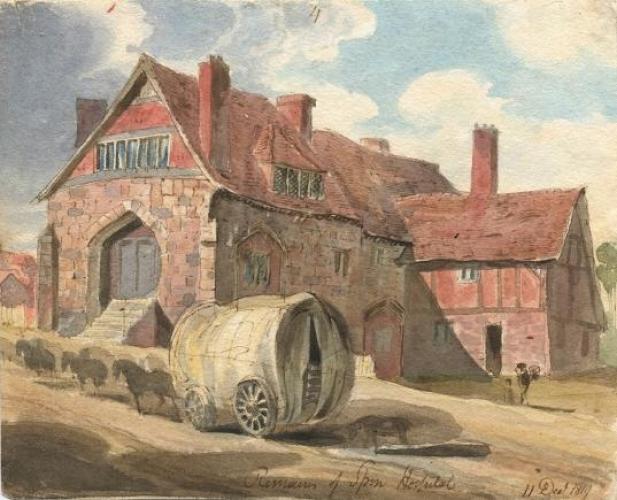 For the packhorse bridge to be that close to the end of the chapel it is either artistic licence or it's further along the river than the current bridge and at a different angle. It's unlikely to be as long as the modern bridge (based on comparing it with the chapel), which also suggests it must have been at a narrower part of the river. It looks to be at right angles to the road but as it was an after thought and meant for horses or people, it didn't need to be for uninterrupted travel, like carts or animals being herded.
The 'fourth arch' from a drawing from the mid 1800s was just a drainage pipe about 2ft diameter. It was just to the right of this picture Anne posted and probably fed the dyers trough. Which means it may be original to the causeway, even if it's not shown on the 1850 map. The causeway may have had to be rebuilt in 1972 because the water was steadily eating out the infill. It may even have collapsed on its own.
For the packhorse bridge to be that close to the end of the chapel it is either artistic licence or it's further along the river than the current bridge and at a different angle. It's unlikely to be as long as the modern bridge (based on comparing it with the chapel), which also suggests it must have been at a narrower part of the river. It looks to be at right angles to the road but as it was an after thought and meant for horses or people, it didn't need to be for uninterrupted travel, like carts or animals being herded.
The 'fourth arch' from a drawing from the mid 1800s was just a drainage pipe about 2ft diameter. It was just to the right of this picture Anne posted and probably fed the dyers trough. Which means it may be original to the causeway, even if it's not shown on the 1850 map. The causeway may have had to be rebuilt in 1972 because the water was steadily eating out the infill. It may even have collapsed on its own.
 But all that is speculation based on a picture with no provenance. It could be fiction.
nb I am happy to repost images already on this site and link to images put online by organisations but I try not to be the first to link or copy to this site from private collections unless they've okayed it. I prefer to drive traffic to their site. I've a long way to go with my project and try not to ruffle people's feelings.
But all that is speculation based on a picture with no provenance. It could be fiction.
nb I am happy to repost images already on this site and link to images put online by organisations but I try not to be the first to link or copy to this site from private collections unless they've okayed it. I prefer to drive traffic to their site. I've a long way to go with my project and try not to ruffle people's feelings. |
| Town Planning and Development - River Sherbourne | |
|
Helen F
Warrington |
193 of 229
Tue 26th Jan 2021 1:21pm
Off topic but related to the photo and the earlier painting of the chapel. Note the chimney growing in height between the two. London apparently started burning coal in about 1620 but Coventry was a poor country cousin by then and would have been slower to take up the new technology. There was a silent but deadly disadvantage in that coal produces more carbon monoxide if the draw from the chimney isn't improved. It's thought that some of the high child mortality in the period post the introduction of coal was down to CO poisoning. Many of the chimneys were rectified by slightly dodgy extensions as you can see with the wonky addition to the chimney closest to the camera. So the jutting bricks partway down the chimneys in old photos weren't a cosmetic feature, they were where the old one stopped. At least that was the original reason. Later builders may have copied it as a style. |
| Town Planning and Development - River Sherbourne | |
|
moriarty
allesley park coventry |
194 of 229
Tue 26th Jan 2021 2:12pm
Helen.
Just like to correct something I posted.
I said the bridge repairs were done while the tower block was constructed. Of course the block was built around 62 and the repairs (demolition) was 72. That postcard shows there was scaffolding all around the embankments and under the concrete base of the block (must have been squeaky bum time down the planners, leaching away the footings). (Postcard is now missing from the site).
Thanks for the links, interesting read. They say the back brook was a tributary of the Sherbourne. All the mills have to have a mill pool to regulate and control the wheel, you can see that around Coventry.
Do you know of a map with a mill pool for Crow Lane? Why would you site a mill on Crow Lane where there is no water, yet 100 yards down the road is the Sherbourne? You can see the supply to the mill was man made as it's contemporary with the medieval gardens along Spon Street.
So I don't think it was as simple as just joining the two up.
|
| Town Planning and Development - River Sherbourne | |
|
Helen F
Warrington |
195 of 229
Tue 26th Jan 2021 7:42pm
Historic Towns Atlas showing Crow Mill
I'm not sure exactly how much they researched that mill and I do know of errors eg there were medieval buildings beyond Barrs Lane on both sides of the road to at least Sherbourne Street. However British History online says that Crow Lane leads to Crow Mill so I assume that someone knows.
Some mills just used long stretches of a stream/river as a pool and as the land was fairly flat along the Back Brook so it didn't just run to one end. A few mills seem to have been run in tandem with another upstream. Alternatively there may indeed be a missing mill pond, gone before 1749, the date of the Bradford Map from which the one above borrows heavily from. There is plenty of space between the Back Brook and the Sherbourne for a long lost pond. The mill would have probably been an undershot mill. |
| Town Planning and Development - River Sherbourne | |

Website & counter by Rob Orland © 2024
Load time: 44ms