
|
Norman Conquest
Allesley |
181 of 264
Tue 30th Dec 2014 12:09pm
Just old and knackered
|
| Streets and Roads - Inner Ring Road | |
| Norman Conquest |
182 of 264
Tue 30th Dec 2014 2:12pm
|
| Rob Orland |
183 of 264
Tue 30th Dec 2014 3:41pm
|
|
NeilsYard
Coventry Thread starter
|
184 of 264
Tue 12th May 2015 3:45pm
Ring Road Racing plans scrapped - I did say that was an impossible proposal....... |
| Streets and Roads - Inner Ring Road | |
|
NeilsYard
Coventry Thread starter
|
185 of 264
Sun 24th Jan 2016 7:22am
The Ring Road arrives.........
 Post copied from topic Gosford Street on 25th Jan 2016 8:51 am
 |
| Streets and Roads - Inner Ring Road | |
|
NormK
bulkington |
186 of 264
Sun 24th Jan 2016 10:49am
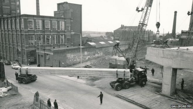
Even with the steerable rear bogey it must have been a tight squeeze in places. Anyone know which route they took, and where were the beams made? Question Milly rules
|
| Streets and Roads - Inner Ring Road | |
|
NeilsYard
Coventry Thread starter
|
187 of 264
Sun 24th Jan 2016 8:46pm
Can't answer your questions Norm but some more interesting images here. |
| Streets and Roads - Inner Ring Road | |
|
Not Local
Bedworth |
188 of 264
Sun 24th Jan 2016 9:50pm
The name on the truck is Dow-Mac. A quick google check shows that Dow-Mac Concrete Ltd was based in Tallington, near to Stamford in Lincolnshire and that they made concrete motorway support pillars. |
| Streets and Roads - Inner Ring Road | |
|
NormK
bulkington |
189 of 264
Mon 25th Jan 2016 8:41am
Not Local..Thanks for the info...  Milly rules
|
| Streets and Roads - Inner Ring Road | |
|
Midland Red
|
190 of 264
Mon 25th Jan 2016 9:13am
Back in 2014, posts were made to a separate thread on the forum regarding slide photographs of the fire at the Ministry of Pensions and NI on Gosford Street and of the construction of the Inner Ring Road
Both of these have their own individual threads, and it is always difficult to know exactly what to do when two distinct subjects are covered by one set of discussions, and as the Inner Ring Road is again in the spotlight, following NeilsYard's recent image addition, it was felt an opportune time to bring those posts relating to the IRR into its main thread here
So, all those conversations which took place in 2014 have been copied into the thread about the fire, and below are reprinted those which relate to the IRR, which some members may not have seen before
On 30th Nov 2014 6:14pm, born and bred said:
A friend of mine asked for help to organise old photo slides. Among them are many photos of the ongoing fire in June 1960's at the Morris factory and of the construction of the coventry ringway. Her father had a chemist shop in the city and was a very keen photographer who took every opportunity to snap whenever he could. My friend was going to bin the slides but as a historian myself l feel that someone would appreciate them.
Can someone tell me where we can donate the please.
Kind Regards.
Carol Collins.
On 1st Dec 2014 7:06am, NeilsYard said:
Thirded! Looking forward to seeing the Ring Road ones.............
On 19th Dec 2014 9:32pm, Rob Orland said:
Right then, time for some more.... here are those Ring Road slides I promised.
There are some really interesting views there, and some that I'm struggling to work out an exact position for, so I hope you will all help out here and have some fun in the process.
The first two images, the aerial shots will be good to sort out - both where they were taken from and which direction.
Number 9 also - where was that one taken from?
And then there's numbers 10, 11, 12 & 13, with Holy Trinity spire virtually hiding behind St. Michael's. Here's a link to Google Maps looking at roughly the same angle.... but it looks so different now! Maybe someone can sort that one out too.
And then on picture 18 the street we're looking at is, I think, now buried under the new sandstone building in this street view. I believe it's the back of the Police Station we're seeing in the old photo.
It would also be good to learn more about the views in photos 19, 20 & 21, which look like Hillfields, but I could be wrong.... and probably am! And the last few.... well, over to you who know so much more.... I'll fill in details on the gallery as we learn more.
Have fun!

On 19th Dec 2014 10:24pm, dutchman said:
Nos 10-13 show the London Road roundabout as viewed from the area outside Elliott's car accessories.
Note that the malting tower of the Midland Brewery is still standing between Much Park Street and Little Park Street on the extreme left of picture #10.
The same malting tower is visible centre-right in picture #24 with Transport House on the extreme left and weavers cottages in Whitefriars Street on the right.
#18 is the original Ringway St John when it was a dual-carriageway with cycle lanes. At the time when the photo was taken it was still possible for vehicles to join the Ringway from what was left of Much Park Street and a car can be seen doing so.
I think #19 has been flipped left-to-right and is a view westwards showing Givens House in Trafalgar Street, Spon End with Spon Gate House in the distance. The Moat Street flyover is in the background. #20 I think is another view of Givens House.
#21 is the Hertford Arms in Hertford Place with the Moat Street flyover behind it.
On 20th Dec 2014 10:25am, NeilsYard said:
Flippin' Ace!
The changes are unbelievable - no wonder its so hard to place areas for anyone of a certain generation...... Thanks for sharing these.
On 20th Dec 2014 3:03pm, Not Local said:
My favourite is Slide 11 which shows that in the 1960's Coventry people drove Coventry made cars. We can see a black Hillman Minx from the early 1950's, a Red Hillman Imp with what could be a 'four numbers and KV' registration number which is a Coventry number from 1963/4, a red and white Hillman Super Minx with a 'four numbers and VC' registration number which is a Coventry number from about 1963, and finally a white Standard Vanguard or Ensign from the late 1950's or early 60's. A similar shot today would show a german car, a french car, a japanese car, and a korean car. I would like to add my thanks for sharing these images.
|
| Streets and Roads - Inner Ring Road | |
|
Dillotford
Stafford |
191 of 264
Mon 1st Feb 2016 1:40pm
On 24th Jan 2016 9:50pm, Not Local said:
The name on the truck is Dow-Mac. A quick google check shows that Dow-Mac Concrete Ltd was based in Tallington, near to Stamford in Lincolnshire and that they made concrete motorway support pillars.
Dow Mac also had another plant at Quedgeley in Gloucestershire, although the larger beams are more likely to come from Stamford.
The beams shown in the excellent photographs are a very early type of a standard bridge beam, namely concrete box beam, it will be about 25m long, as that was their max length when they were pre-tensioned. These beams were quite inefficient due to their large dead weight.
No hard hats in sight and working from ladders rather than scaffold, contributed to the construction high risk status of that time, a lot has changed since! |
| Streets and Roads - Inner Ring Road | |
|
pixrobin
Canley |
192 of 264
Tue 19th Jul 2016 3:11pm
For various reasons it shouldn't really be said to be sited in Cannon Park but Canley. The border betweed Canley and Westwood is Shultern Lane itself. The original continuation of Kirby Corner Road was what is now Moat House Lane. To the west of that was Fletchamstead. Cannon Park is merely a modern name for the area which for centuries had belonged to Tocil and prior to that Cryfield.
Does anyone know why Charter Avenue and Mitchell Avenue were made as dual carriageways?
Post copied from topic Canley (inc. Sir Henry Parkes School) on 19th Jan 2017 8:08 am
|
| Streets and Roads - Inner Ring Road | |
|
Slim
Another Coventry kid |
193 of 264
Thu 21st Jul 2016 12:22pm
I guess it was future-proofing. As a child, I lived just off Four Pounds Ave. It was always a single track road, but the bed for a dual carriageway had always been there. Year after I left, they made it into the dual carriageway it is now.
I seem to remember, from the 70s, plans for a massive housing development at Mitchell Avenue. The company I then worked for quoted for the elctrics. It seem they never built it. Probably too close to the Uni, The Science Park, and now the Business Park. |
| Streets and Roads - Inner Ring Road | |
|
Tony1
Coventry |
194 of 264
Thu 25th Aug 2016 5:39pm
On 19th Jul 2016 3:11pm, pixrobin said:
Does anyone know why Charter Avenue and Mitchell Avenue were made as dual carriageways?
Dual Carriageway - I am not 100 % sure but it's worth checking up with the local authority.
The carriageway starts close to the woods side of the Charter Avenue island. The intentions I believe were to link Canley and Tile Hill with a road going under the railway line and coming out by the what was the Co-op bakery in my time. Where the University grounds start today I believe it was scheduled to expand the motor industry to take away the congestion from the other side of the highway where many components were produced. Somewhere along the line it was going to link up with the highway.
|
| Streets and Roads - Inner Ring Road | |
|
Harrier
Coventry |
195 of 264
Tue 13th Sep 2016 8:59pm
When I came down to Coventry I was told that the grand master plan was that historically Coventry would have three ring roads, inner, middle and outer all linked with a series of radial roads. Just as Charter Avenue was supposed to be a radial, Four Pounds plus Beake Avenue was going to be part of the middle ring road, hence the bit of Radford Road by the rec. that bisects it, is the starting of a dual carriageway (then up to Tamworth Road) as another radial. And of course, the other end of Four Pounds is the start of another radial - the Allesley Old Road. Of course, the A45 was part of the outer ring road. Unfortunately the time frame for the house buildings alongside the dual carriageways don't fit logically into such a master plan. |
| Streets and Roads - Inner Ring Road | |

Website & counter by Rob Orland © 2024
Load time: 26ms