
|
SJT
Brisbane, Australia |
151 of 234
Fri 3rd Jul 2020 3:14am
Thank you Midland Red, Kaga and Helen F. Great to be able to confirm these details for my historical fiction project. I've finished the second draft of the English parts I-III and I'm just going back over it to make sure it's as accurate as I can make it. Part IV (or book two maybe if I split it) is set in Van Diemens Land. I so hope I make it to Coventry one day to shout you all a pint.
|
| Town Planning and Development - River Sherbourne | |
|
scrutiny
coventry |
152 of 234
Sat 7th Nov 2020 3:31pm
The Sherbourne ran under Gilbert's in the Burges. The topic Burges & Cross Cheaping, post 180 has a photo. |
| Town Planning and Development - River Sherbourne | |
|
Rob Orland
Historic Coventry |
153 of 234
Sat 7th Nov 2020 4:01pm
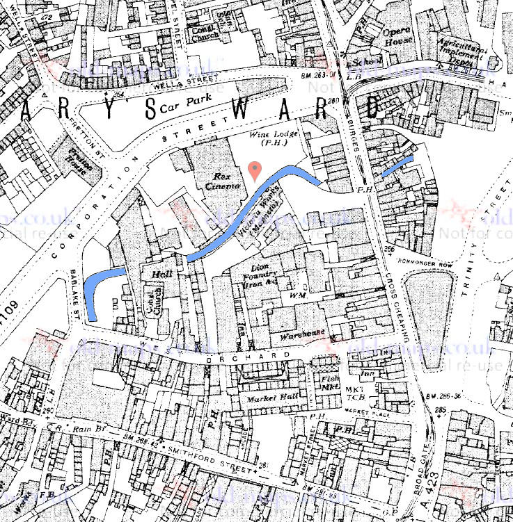
As per Helen's post above, does this map help?
 Post copied from topic West Orchard on 8th Nov 2020 12:52 pm
 |
| Town Planning and Development - River Sherbourne | |
|
Midland Red
|
154 of 234
Sat 7th Nov 2020 5:17pm
On 7th Nov 2020 3:31pm, scrutiny said:
The Sherbourne ran under Gilbert's in the Burges. The topic Burges & Cross Cheaping, post 180 has a photo.
I think the Sherbourne runs under the Coventry Cross - Gilbert's is several doors further north, beyond the Palmer Lane entry  |
| Town Planning and Development - River Sherbourne | |
|
Helen F
Warrington |
155 of 234
Sat 7th Nov 2020 6:48pm
Split the difference and go for the City Mini Market next door to the north? Proof if it was needed that the city is thoroughly confusing. |
| Town Planning and Development - River Sherbourne | |
|
mcsporran
Coventry & Cebu |
156 of 234
Sun 8th Nov 2020 12:40am
Looking at that wonderful map (post 153), it seems to me a reasonable assumption that the Sherbourne at some earlier date crossed Burges lower down where there's a gap in the buildings both sides. The apparent 'uphill' bend of the river on the west/left side of the road means it had to be culverted to go underneath. Maybe when the tramlines were laid (1890s), they couldn't cope with the hump of the bridge so close to the curve into Hales Street? |
| Town Planning and Development - River Sherbourne | |
|
Rob Orland
Historic Coventry |
157 of 234
Sun 8th Nov 2020 10:30am
On 7th Nov 2020 6:48pm, Helen F said:
Split the difference and go for the City Mini Market next door to the north? Proof if it was needed that the city is thoroughly confusing.
Yes, it is the Mini Market Helen....
Google view from the Burges (Zoom in on the map plan below the street-view.)
Google aerial view
Greeny's super photo from Palmer Lane (The lower rear roof of the Mini Market can be made out on the aerial view linked above.) |
| Town Planning and Development - River Sherbourne | |
|
Helen F
Warrington |
158 of 234
Sun 8th Nov 2020 11:23am
mcsporran, it's hard to know what the original route of the river was or even what level it was at because there was so much tinkering going on to both the river and the land, although I think that the bridges (Radford Brook and Sherbourne) were fairly ancient.
Pictures showing original paddle stone cobbling often show steps up to front doors, suggesting that the road surfaces were anywhere from a foot to a yard lower. I don't know when pavements came in but I don't think they had them originally. Each time they repaired the roads I'm sure that they tried to make them easier to drain and run carts over. The earliest crossings would have been fords and the river overall would have been wider and shallower with significant meanders. The reference to the Babu Laku, could have meant that a substantial part between Bablake and Cox Street skirting the hill, could have been flooded and was at least marshy. Pool meadow was created by the monks to keep fish but they may have exploited existing pond features.
The area between Bablake and the Bastille Gate was supplied by multiple water sources and I have a suspicion that at least 1 river/stream vanished after they built the canal. From the arrival of the monks I think that they set about controlling the rivers. They would have excavated the river bed for sand and pebbles and possibly to deliberately deepen it. They narrowed the banks. Probably with posts to start but eventually with stones and brick. They built dams and mill races to control both the speed and quantity of water fed to each mill. Sometimes the mill race became the main channel and that led to a straightening of stretches of the River. It's possible to see it in the maps of the river running from Gosford Street to the south. There is at least 1 weir (near where the river passes under the wall south of Fleet Street) that predates 1850.
Prior to the 1800s, most of the river was visible with only a few buildings built over the river. The oldest parts I know of are St Georges Hall at Gosford; the Bastille Mill; and a building/bridge between Smithford Street and West Orchard, which may have also been a mill. The Radford Brook may have been built over at the Burges but I'm not 100% sure if the library to the Grammar School was over it or if there was a small gap. It wasn't very big so it may have been one of the earliest bits to be culverted. Although it was open just beyond the buildings fronting the street until Hales Street was built. As was the Sherbourne at the Burges on the east side. The 1610 map shows the Grammar School without the library so at that point the brook would have probably been visible. The other place that the Sherbourne had probably had early buildings over was Palmer Lane but no images remain that I know of so I can't say how old.
At the same time the rivers were changing, the land was built up too with demolition, rubbish, soil and buildings. Most cities, including Coventry are built on layers of the past, to a startling amount. The area around the Burges was quarried for sand and gravel to build the castle and the whole area at the town centre was peppered with quarries for stone. The holes became rubbish pits and cellars. Where the original land surface was is anyone's guess.
Coventry is thoroughly man made, including its waterways. |
| Town Planning and Development - River Sherbourne | |
|
mcsporran
Coventry & Cebu |
159 of 234
Tue 10th Nov 2020 12:33am
Thank you Helen , such a detailed response deserves a reply. The justification for my theory was that culverting a river can't be done in place, you have to build the culvert separately then divert the river into it. Also I assumed further 'up' Burges would give more headroom, but now looking at the spot heights on the map, I notice the road is actually near enough level, the real slope begins at Cross Cheaping, hence the entrances of the newer Owens were on the ground floor at the front, and lower ground floor at the back.
The unfortunate thing is that by the time they invent time travel, nobody will be interested in investigating what the past was really like, they'll be too busy devising a way to get off this ruined planet to start over somewhere else.  |
| Town Planning and Development - River Sherbourne | |
|
CliffB
Coventry |
160 of 234
Fri 13th Nov 2020 5:09pm
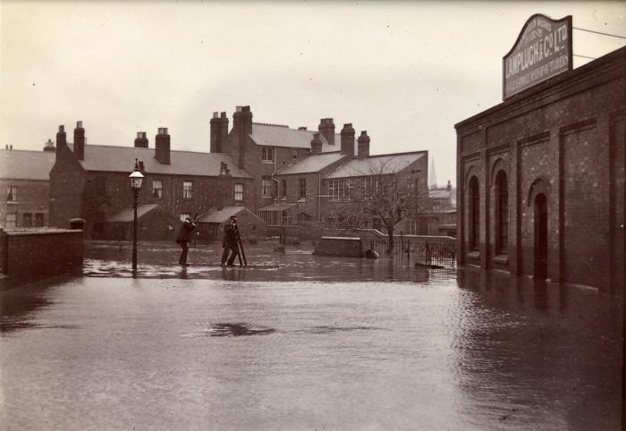
The flooded Sherbourne from the Rover Works in Garfield Road, I guess this is the 1900 New Year's Eve flood.
Didn't know punting was a Coventry thing  Thanks to Celia Clare again.
|
| Town Planning and Development - River Sherbourne | |
|
Helen F
Warrington |
161 of 234
Fri 13th Nov 2020 6:03pm
Thanks again to Celia and Cliff - you can see a tide mark on the buildings and there is a similar photo in the library from the top of another building and the water was just at the bottom of the windows on the right. So this was as the floods receded.
mcsporren - re culverting - because the rivers and streams had sluices for the mills, they could probably hold back the water for a while as they did various stages of the work. When they did the work near Pool Meadow, they seem to have shuttered off the relevant banks, while the river flowed on the other side. |
| Town Planning and Development - River Sherbourne | |
|
NeilsYard
Coventry |
162 of 234
Sat 14th Nov 2020 1:53pm
Helen, can you work out the angle of the photographer from maps? I'm struggling..... |
| Town Planning and Development - River Sherbourne | |
|
Helen F
Warrington |
163 of 234
Sat 14th Nov 2020 3:46pm
I think that it's taken from the Meteor Works itself, looking towards Queen Victoria Road, which you can just see on the left. The building in the middle with the rear extensions is about two houses from the river on the right.
The river has pushed over the garden wall which stretched from the little bit remaining by the tree all the way to the back corner of the house on Queen Victoria Road. |
| Town Planning and Development - River Sherbourne | |
|
Annewiggy
Tamworth |
164 of 234
Sat 14th Nov 2020 5:54pm
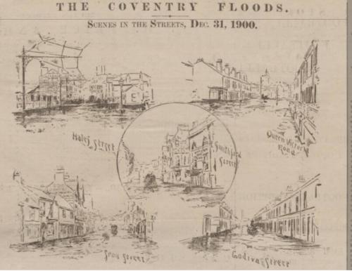
Looking through the newspapers for articles about the 1900 flood I came across this
|
| Town Planning and Development - River Sherbourne | |
|
CliffB
Coventry |
165 of 234
Sat 14th Nov 2020 6:48pm
On 14th Nov 2020 3:46pm, Helen F said:
I think that it's taken from the Meteor Works itself, looking towards Queen Victoria Road, which you can just see on the left. The building in the middle with the rear extensions is about two houses from the river on the right.
The river has pushed over the garden wall which stretched from the little bit remaining by the tree all the way to the back corner of the house on Queen Victoria Road.
Yes, I believe this is taken from the Meteor Works entrance Helen, I also have photos taken from the upstairs windows, some include views over the buildings up to the Abbott's Lane gas tanks. |
| Town Planning and Development - River Sherbourne | |

Website & counter by Rob Orland © 2024
Load time: 177ms