
|
Rob Orland
Historic Coventry |
151 of 192
Tue 10th Nov 2020 12:40pm
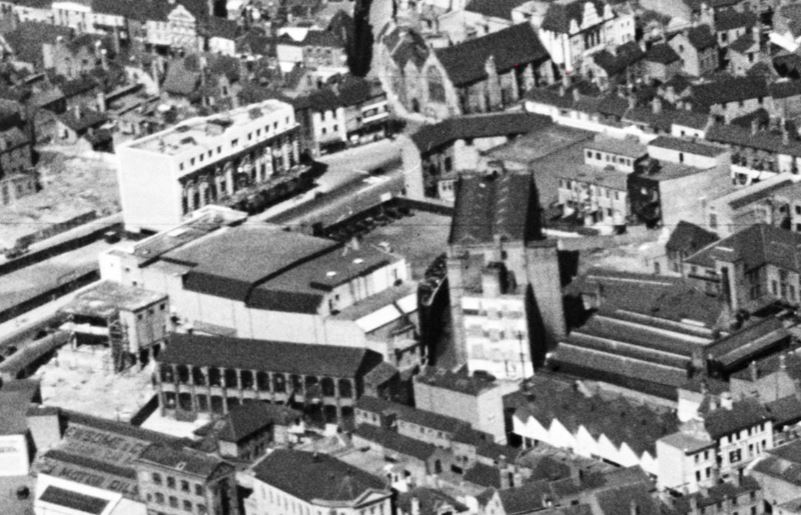
Does this 1937 NE looking aerial view from Britain From Above help? With the Old Grammar School in the background as a reference, we can see in the centre of the photo the Rex on the left and Meteor Works to its right, forming a V shape. It appears to be the equal and opposite view to Neil's photo in post 120, which was looking SW
|
| Streets and Roads - West Orchard | |
|
Rob Orland
Historic Coventry |
152 of 192
Tue 10th Nov 2020 12:50pm
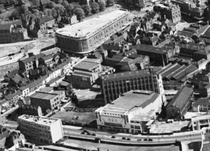
This view looking south east, also from 1937, is even better. Look at the style of windows on the Meteor Works, and the sign in the centre of it. Helen, you were spot on all along. 
|
| Streets and Roads - West Orchard | |
|
Kaga simpson
Peacehaven, East Sussex |
153 of 192
Tue 10th Nov 2020 1:05pm
Helen,
I doubt that with the Wine Lodge off the corner of the Burges and the shape of the Owen Owen building on, and the fire steps that small, and Trinity Street, it's as I thought - a jumble of maps that don't fix a date. That area was a mass of old buildings that changed hands every few days as far as we know.
The Rex was a brand new site, with everything to put Coventry to the front, not scruffy at all. I'm sorry I just can't see it, now I'm just looking for a date. |
| Streets and Roads - West Orchard | |
|
Kaga simpson
Peacehaven, East Sussex |
154 of 192
Tue 10th Nov 2020 3:25pm
Helen
I have been looking at the maps again, and everything seems to add up, that you are right. I can't see a better spot. I am very sorry to have doubted you, and mine is a very distant memory.
Sorry. Kaga. |
| Streets and Roads - West Orchard | |
|
Helen F
Warrington Thread starter
|
155 of 192
Tue 10th Nov 2020 3:59pm
No problem Kaga.  Those maps and the aerial photos are well worth a good rummage. One tip is to get a log in account to the aerial photos site - Britain From Above. That way you can zoom in and see more detail. It's how I solve most of the questions. I enter Coventry into the search box and have looked carefully at every one I think might be useful and then a few I didn't. Some are poor, some are too far away but they've got a wealth of information.
Wander about the city and refresh those amazing memories of yours
Link to Britain From Above with Coventry set Those maps and the aerial photos are well worth a good rummage. One tip is to get a log in account to the aerial photos site - Britain From Above. That way you can zoom in and see more detail. It's how I solve most of the questions. I enter Coventry into the search box and have looked carefully at every one I think might be useful and then a few I didn't. Some are poor, some are too far away but they've got a wealth of information.
Wander about the city and refresh those amazing memories of yours
Link to Britain From Above with Coventry set |
| Streets and Roads - West Orchard | |
|
moriarty
allesley park coventry |
156 of 192
Mon 16th Nov 2020 12:32pm
This is a very interesting topic as I didn't realise there were all these early factories behind Corporation Street. We sometimes caught the bus from opposite the Gas Showrooms (there was a row of bus shelters there at one time and it was a very busy area). It must have been easy to see these factories but I don't recall them.
I do remember the Rex market, I was very young and was taken in it just one time. On maps it is shown as the whole of the Rex complex but I'm not sure that is right - there were two entrances, one east, one west and just a path between where the traders were. There seemed to be some sort of barrier to the auditorium. Much later I do remember walking through a gap between shops in the Burges opposite the Coventry Cross pub, to the right was a small wall and looking over it you could see the sad little Sherbourne. The whole area was rubble, completely destroyed by the council - no elf and safety then - and further up the top casement of the river had been opened, this of course would have been pre-car park and Smithford Way.
Looking back through the posts it seems the buildings are getting mixed up, so to recap...
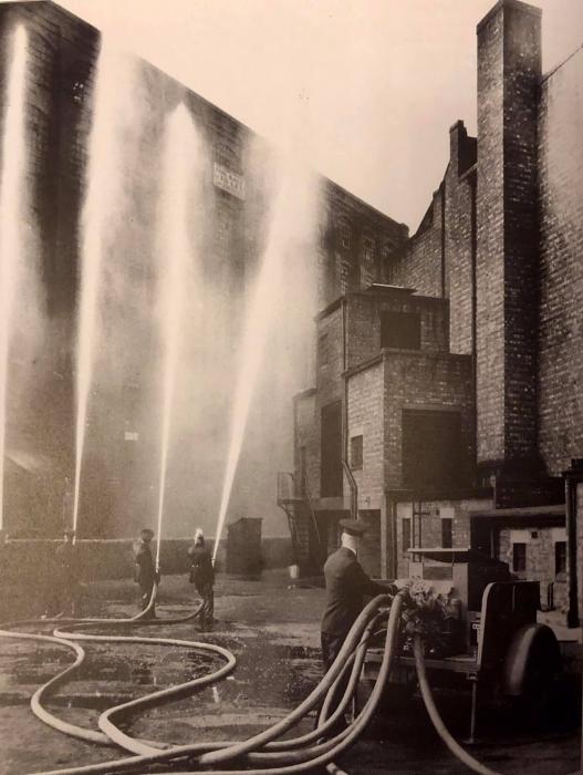
The above image is taken on the Rex car park, the Rex is on the right. It's a demonstration or test, the jets are not playing on the building (as has been said) but the building is the Victoria (mills), the water is returning to the Sherbourne just over the wall.
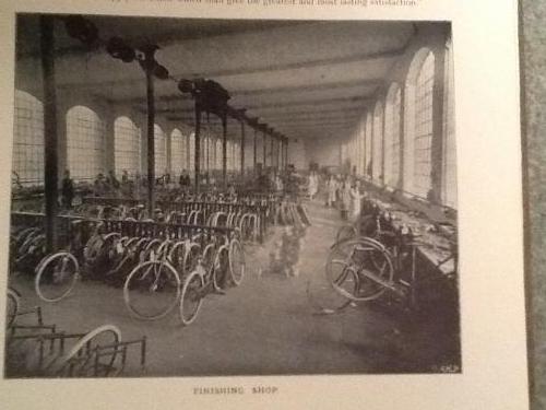 The above image is correctly labelled Meteor Works, the windows are arched and very similar to the Victoria building. It looks like the ground floor, but this building is to the west of the Rex complex and has only a few floors.
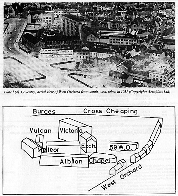 The drawing above shows you the Meteor building in relation to Victoria (mills). So Rover moved from this Meteor building to Queen Victoria Road and established a factory there (is it the Iceland supermarket now?).
Hope you don't mind me borrowing the photo's - thanks.
The drawing above shows you the Meteor building in relation to Victoria (mills). So Rover moved from this Meteor building to Queen Victoria Road and established a factory there (is it the Iceland supermarket now?).
Hope you don't mind me borrowing the photo's - thanks. |
| Streets and Roads - West Orchard | |
|
Helen F
Warrington Thread starter
|
157 of 192
Mon 16th Nov 2020 1:29pm
Well summed up moriarty. The bulk of the factories had gone by the time the Rex Market was in operation, but there were buildings with Rex in their title flanking the entrance to the area. You probably couldn't see the Victoria Works from Corporation Street at that time and once in the market there would have been far more interesting things to look at. I've found the post war photos useful because the missing buildings opened up views that weren't there before. |
| Streets and Roads - West Orchard | |
|
Kaga simpson
Peacehaven, East Sussex |
158 of 192
Tue 17th Nov 2020 11:35am
Helen
And you couldn't see Corporation Street or Queen Victoria Road from that fireman photo, only when you walked in from the Burges as I remember. |
| Streets and Roads - West Orchard | |
|
moriarty
allesley park coventry |
159 of 192
Tue 17th Nov 2020 12:40pm
Yes, I see what you mean. Rob's photo 152 does show a lot is hidden behind the Rex especially if you were a little kid! It depends how much Rex was left standing after the war.
Incidentally have you noticed how the camera can lie. Rob's photo 152 shows the rear left corner of the Rex halfway down the Victoria building, yet in 151 photo (that left corner) it's level with the end of the Victoria building (the front right hand side of the Victoria building).
In the photo 152 there appears to be an extra tower attached to the front right hand edge of the Victoria building.and yet in 151 it seems to disappear. Of course it is the attached white tower on the end which is at an angle (the reference to the buildings is looking south from Corporation Street).
I'll stop now! |
| Streets and Roads - West Orchard | |
|
Helen F
Warrington Thread starter
|
160 of 192
Tue 17th Nov 2020 1:30pm
The funny shaped white building on the end of the Victoria Works is what was left of the Exchange Works (demolition pre war)? Whether it held stairs or whether they thought it was serving to prop up that end of the Victoria works, we'll never know. How much of the Rex survived behind the front buildings I also couldn't say. The first maps and aerial views show it all gone, apart from the side buildings fronting the street. |
| Streets and Roads - West Orchard | |
|
Kaga simpson
Peacehaven, East Sussex |
161 of 192
Wed 18th Nov 2020 11:27am
Rob's post 152 clearly shows the Rex cinema but not the shops and offices attached either side, as both an older, and famous, member and I agreed were there during its short period. I have no answer for this. but this was long before the market, little of the area was visible for it was all tall buildings, on all three sides of the area, except the tall buildings that towered above, congested, smelly, hidden, it was not visited by strangers as there were no shops or market. |
| Streets and Roads - West Orchard | |
|
Kaga simpson
Peacehaven, East Sussex |
162 of 192
Thu 19th Nov 2020 8:41am
I think Boots had a shop just below West Orchard, when it was bombed it became most of the market at the back of the old Rex, in its own backyard practically. |
| Streets and Roads - West Orchard | |
|
Kaga simpson
Peacehaven, East Sussex |
163 of 192
Fri 20th Nov 2020 9:58am
Moriarty
So when was Victoria Mills knocked down? 1937, the Meteor was the largest building that side of WO and it survived the blitz. The same as the other side of WO, the largest building was the market tower that survived too.
On post 156 you said the council had made the rubble. I would say the Germans made the rubble. It would have been foolish to have moved it before the end of the war, and after the war the council had larger things to build. To me the Rex market was not official like the temp shops they built. And the council were very safety minded, they had troops in before the all clear sirens had finished, to rope off or place barriers around unsafe areas.
No, the Council made their mistakes before the raid, like issuing hundreds of Anderson shelters, instructing people to put earth over them, then constructing street shelters and placing great concrete slabs over them. |
| Streets and Roads - West Orchard | |
|
NeilsYard
Coventry |
164 of 192
Fri 20th Nov 2020 5:09pm
On 20th Nov 2020 9:58am, Kaga simpson said:
So when was Victoria Mills knocked down?
Kaga, my picture in post #122 is the mill being bulldozed - I think it was mid-60's to build the West Orchard multi-storey.
|
| Streets and Roads - West Orchard | |
|
NeilsYard
Coventry |
165 of 192
Fri 16th Apr 2021 1:54pm
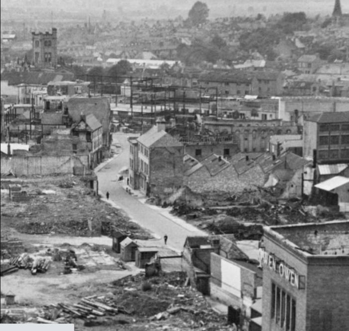
An interesting aerial from my friend Dean Nelson on FB - any idea what those remaining buildings were anyone?
|
| Streets and Roads - West Orchard | |

Website & counter by Rob Orland © 2024
Load time: 33ms