Topic categories:
(Alphabetical)

Spon End

You need to be signed in to respond to this topic

First pagePrevious page

Displaying 151 to 165 of 253 posts

Page 11 of 17

1 2 3 4 5 .... 10 11 . 13 14 15 16 17
Next pageLast page
253 posts:
Order:   

Malvern
Somerset
151 of 253  Mon 16th Jan 2017 7:57pm  

I've been going through the census records and identifying where my family lived between 1800 and 1939. Here's a list together with an image from 1920 and a map of the Moat Street/Butts area: 1800-1900 Shakespeare Yard, Spon Street 1840-1870 Bailey Lane Court (Great-grandfather's birthplace) 1880-1890 White Horse Yard, 4 East Street (Grandfather's birthplace) 1890-1900 Court House, 13 Spon Street 1900-1910 8 Thomas Street 1910-1920 23 Moat Street 1910-1920 1 League Place, Moat Street 1920-1940 5 Hertford Place (Father's birthplace) I was christened at St Thomas, The Butts in 1963. Image courtesy of Britain from Above The playing fields at the bottom are where the Technical College was built with St Thomas on the corner of Albany Road and The Butts. Hertford Place, Thomas Street and Moat Street are all just beyond. As detailed in earlier posts Moat Street is now where the Ring Road cuts through and 5 Hertford Place is now the car park of the radio station.
Malvern

Streets and Roads - Spon End
NeilsYard
Coventry
152 of 253  Tue 4th Apr 2017 11:57pm  

Thanks to Carol Vale - here's a great rare small image of the original properties that were next to the Old Dyers Arms. Carol was born in the end house to the right which was No.8
Streets and Roads - Spon End
Midland Red

153 of 253  Mon 17th Apr 2017 1:04pm  

On 17th Jun 2012 10:41am, Baz said: 
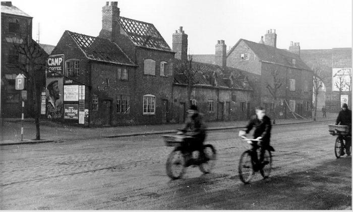
The Arches in Spon End have another story to be told about them. In 1857, 23 of the 28 Arches fell down and the line was not in use for some time after. As you drive under them, you will see the difference in brick work. The replaced bridge was of bricks, the original was of sand stone. It happened only 7 years after the line had opened. Thumbs up
Coventry Herald - Friday 30 January 1857 FALLING IN OF THE RAILWAY VIADUCT, SPON-END. At an early hour on Monday morning last, the inhabitants of Coventry were startled by a report that the whole, or the greater part, of the Railway viaduct, at Spon-end, had given way. The rumour, as may well be imagined, caused considerable excitement: but not a few doubted its truth, and extent of the calamity was at first supposed to be much exaggerated. On proceeding to the scene of the disaster, however, we found that out of twenty-eight arches only five remained standing, and those which had fallen in presented the appearance of the most complete destruction possible. We understand that the first notice of danger was afforded some few minutes past twelve o'clock on Sunday night, when a few stones fell from one or two of the arches. At about one o'clock in the morning the greater part of the viaduct fell in with a loud crash, persons living in the neighbourhood being very much shaken by the shock while sleeping in their beds. Some timid individuals imagined that an earthquake was taking place, and they were kept for some little time in a state of painful suspense and alarm. Other parts of the viaduct fell in between two and half past six o'clock, and it was feared that the arches which remained standing would give way in the course of the morning, the Police having strict instructions to prevent all persons from approaching too closely those parts where danger was to be apprehended. Up to the present moment, however, the further progress of the ruin has been stayed. From all that can be seen of the materials of which the viaduct was built, they do not seem calculated for a work of so much importance as that in the construction of which they were used. Had a train have been passing at the time of the catastrophe, or had the accident taken place in the day, it is impossible to calculate the sad results which might have followed. It is hoped that no lives have been lost, and, although a rumour is in circulation that an Italian boy was sleeping under one of the arches on the night the accident, this report has not yet been confirmed. It is stated that the accident was caused in consequence of the foundations of the arches having given way, but at present it is impossible to obtain any precise information on the subject. We understand that arrangements have been made in order that the public may not suffer any serious inconvenience from this alarming accident. An omnibus will run regularly between the Coventry and Coundon-road Stations, and thus no interruption of the traffic will take place. The Coundon-road Station is to be enlarged, so that it may temporarily serve the purpose of a terminus; and we may suggest that it would a great advantage to the inhabitants of Coventry if the piece of land belonging to the Company, adjoining that Station, were for the present made to serve as a coal-yard. We regret say that Mr. Jordan, miller, has suffered considerably from the above accident, the river Sherbourne being turned from its bed by the mass of matter falling therein, swamped the fields in the neighbourhood, and, invading Mr. Jordan's mill, the water damaged above 90 sacks of flour. Several carts, belonging to the same gentleman, which were beneath one or two of the arches at the time they gave way, are of course destroyed. The viaduct was about a quarter of a mile in length, and consisted of 28 arches, each 40 feet span, and 15 feet rise. The piers in the valves, which averaged about 15 feet, were built of stone obtained from a quarry near the residence of Mr. C. Bray. The first stone of the structure was laid August, 1848, and the last stone was placed in its bed on Friday, June 29, 1849; so that little more than ten mouths elapsed in completing it. It was erected under the superintendence of Mr. Warriner, the engineer to the Company; Messrs. Shaw and Hayton being contractors, and Messrs. Newell, Robson and Ainsworth, sub-contractors. The whole work was commenced and finished without any accident. The following account of the above accident appeared the London Times of Tuesday morning, and has since been copied into the morning papers. As a choice specimen of the accuracy of local reports furnished to London journals, we give it verbatim:- "Fall of a Railway Bridge.
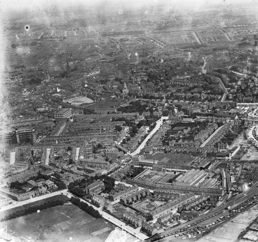
Streets and Roads - Spon End
VernonDudleyBohay-Nowell
Coventry
154 of 253  Fri 22nd Sep 2017 10:08pm  

Members may be interested to know that volunteers from the Coventry and District Archaeological Society are presently excavating the garden at the rear of The Broomfield Tavern. I understand that the landlady was curious to know what was there before the garden and was prompted by the recent dig when the new Bethel church was constructed. There are pictures on the society's Facebook page of the foundations that have been exposed by the CADAS work. According to old maps (notably that of 1905) there were 3 cottages adjoining (sideways) the back of the Broomfield Tavern - I guess the remains of these will eventually be exposed. My family lived in Court 1 around 1911 and I wondered if one of those cottages might be be theirs. Unfortunately there's no real way of telling as I can't find any way of equating the houses with a postal address. And it's not obvious which way the enumerator went around Court 1 during the census. The dig might be worth a visit - and it's a great excuse to go to the pub.
Streets and Roads - Spon End
NeilsYard
Coventry
155 of 253  Sat 23rd Sep 2017 10:30am  

Thanks for the heads-up on that Vernon Thumbs up My mate's brother runs that place - must find out more!
Streets and Roads - Spon End
NeilsYard
Coventry
156 of 253  Sat 23rd Sep 2017 12:22pm  

Just had a dig around (no pun intended!) Vernon. This is from a 1905 map and you can see Court 1 block was actually further west than where the Tavern is so probably not your family's old houses.
Streets and Roads - Spon End
VernonDudleyBohay-Nowell
Coventry
157 of 253  Sat 23rd Sep 2017 12:39pm  

Think you'll find that's Court 1 Hearsall Lane, Neil. Look at the same map the other side of the railway arches and you'll see 'my' Court 1 at the back of the Broomfield Tavern. The Spon End courts number from the Old Dyers Arms. Confusing things, courts!
Streets and Roads - Spon End
NeilsYard
Coventry
158 of 253  Sat 23rd Sep 2017 1:07pm  

Ahh yes apologies Vernon - got my Broomfields mixed up! Big grin
Streets and Roads - Spon End
Helen F
Warrington
159 of 253  Sat 23rd Sep 2017 1:31pm  

The Chapel was built on the land that was the Cock Court off Spon End, later renamed Court number 1. The following report tells you about the area. It includes maps and old images of the Cock pub. Report of the Bethel Church dig There are images of the area at Pictures From Above. What CADAS might find is waste pits from when the Cock/Unicorn was a pub/hostel and later when it was a school.
Streets and Roads - Spon End
VernonDudleyBohay-Nowell
Coventry
160 of 253  Sat 23rd Sep 2017 1:55pm  

Thanks, Helen. I remember seeing an even more comprehensive report by the architects - with maps from many sources. Their report has disappeared from the web but I've asked them if they've got an archived copy. The report that you linked was a desk-based assessment with just a site visit before work started - I wonder if anyone examined the ground and/or recorded their findings as work to construct the new Bethel commenced?
Streets and Roads - Spon End
Helen F
Warrington
161 of 253  Sat 23rd Sep 2017 2:23pm  

They probably did but if there wasn't much to say, they may just have kept the information in house. There was another dig a bit further west that found bodies from the leper hospital a few years ago. In some ways the back garden might have more information than the chapel although the post 1850 houses may have destroyed it. They seem to release information in collections in book form every so often so maybe there will be one about Spon Street soon? Most of the stuff I've found online so far has been almost by accident. There doesn't seem to be a single repository. I missed the boat on the book on the Much Park Street dig and the reasonable priced copies are all gone Sad . If I keep looking things turn up for the right price. I just got a copy of the Whitefriars excavation book by Charmian Woodfield for twenty something. Big grin
Streets and Roads - Spon End
NeilsYard
Coventry
162 of 253  Fri 6th Oct 2017 4:48pm  

Don't think we've seen this one before - thanks to the Bygone Spon End Facebook page.
Streets and Roads - Spon End
Prof
Gloucester
163 of 253  Fri 6th Oct 2017 8:50pm  

Is this looking towards the Butts, with the later Plaza Cinema and Renold and Coventry Chain firm on left, Hearsall Lane on right, just out of the picture?
Streets and Roads - Spon End
Midland Red

164 of 253  Fri 6th Oct 2017 9:42pm  

Just about - it's taken from the bottom of Hearsall Lane. The tall building on the left is the Black Horse
Streets and Roads - Spon End
NeilsYard
Coventry
165 of 253  Sun 19th Nov 2017 12:34pm  

A very rare image courtesy of the Bygone Spon End FB page. There was a lady on here (or it may have been FB!) some time ago that was asking for an image that captured this row - for some reason they always seem to be missed off most other old Spon End images of the era.
Streets and Roads - Spon End

You need to be signed in to respond to this topic

First pagePrevious page

Displaying 151 to 165 of 253 posts

Page 11 of 17

1 2 3 4 5 .... 10 11 . 13 14 15 16 17
Next pageLast page

Previous (older) topic

Jordan Well
|

Next (newer) topic

Lost Coventry views (photos wanted)
You are currently viewing topics in All categories
View topics only in the Streets and Roads category
 
Home | Forum index | Forum stats | Forum help | Log out | About me
Top of the page
3,320,492

Website & counter by Rob Orland © 2024

Load time: 28ms