
|
Rob Orland
Historic Coventry |
16 of 163
Mon 24th Oct 2011 9:32pm
I have a 1954 Coventry street plan and one that's probably late 50s. They're too large to get into one whole image, but I can scan any parts of them that you require and email them if necessary. Will that be any use? |
| Local History and Heritage - Maps of Coventry | |
|
InnisRoad
Hessle |
17 of 163
Thu 27th Oct 2011 8:13am
On 24th Oct 2011 1:46pm, dutchman said:
This offer may be worth a try: LINK
I have ordered the map, so I'll let you know what it covers.Regards Innis Road
|
| Local History and Heritage - Maps of Coventry | |
|
Greg
Coventry |
18 of 163
Thu 27th Oct 2011 4:17pm
I have the book in front of me as I took it out of Foleshill library today. It covers the area out to Keresley, Longford, Walsgrave, Binley, Willenhall, Stivichall, Tile Hill, Lower Eastern Green (Banner Lane) and Allesley. |
| Local History and Heritage - Maps of Coventry | |
|
InnisRoad
Hessle |
19 of 163
Sat 29th Oct 2011 9:25am
I now have the map in my possession, thanks to excellent service from Reprint.
The first thing to say is that it's not an OS-based map, but a street map of the A-Z type with different sections on different pages. It also has a bus map. However, although it claims to be a map of 1950 it is actually somewhat later. The date error probably arises because it was compiled from a collection of loose pages found in a box. The street maps show the completed Tile Hill North, Wood End, Willenhall and Stoke Aldermoor council estates and the completed Allesley Park estate. None of these had been started in 1950. It also shows Four Pounds Avenue as a traffic route, which was not upgraded until after 1956. It does not show Allesley Hall Drive, which was begun in 1960. The bus maps are certainly later than 1950 and the best date that I can estimate from the bus maps is 1959. I can let you have more details of the date estimate if anyone is interested. Regards Innis Road
|
| Local History and Heritage - Maps of Coventry | |
|
dutchman
Spon End Thread starter
|
20 of 163
Sat 29th Oct 2011 1:25pm
Thanks InnisRoad
 |
| Local History and Heritage - Maps of Coventry | |
|
K
Somewhere |
21 of 163
Wed 7th Dec 2011 1:37pm
In the book about Coventry by A Nonny Mouse that I acquired, and posted the adverts, there is this rather nice 1656 map. I thought you all might like to see it:
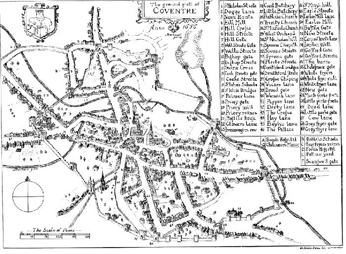 Rather nice, as it shows the city wall rather well. If anyone wants a high-res version, e-mail me, and I'll send it.
 |
| Local History and Heritage - Maps of Coventry | |
|
Midland Red
|
22 of 163
Wed 7th Dec 2011 1:42pm
One of John Speed's maps
It's included in Levi Fox's "Coventry's Heritage" as well |
| Local History and Heritage - Maps of Coventry | |
|
K
Somewhere |
23 of 163
Wed 7th Dec 2011 1:45pm
I don't have that. The definition in the book is quite good. It would have been nice to see the original!  |
| Local History and Heritage - Maps of Coventry | |
|
Foxcote
Warwick |
24 of 163
Fri 28th Sep 2012 12:28pm
I've just found a good site for maps, didn't quite know where to tell you  But it looks and interesting free access affair, maybe everyone knows anyway cept me?
Old Map access I think it opens up, just checked and it opened for me, don't want to trick the Dutchman again But it looks and interesting free access affair, maybe everyone knows anyway cept me?
Old Map access I think it opens up, just checked and it opened for me, don't want to trick the Dutchman again  |
| Local History and Heritage - Maps of Coventry | |
|
dutchman
Spon End Thread starter
|
25 of 163
Fri 28th Sep 2012 3:13pm
Good find Foxcote I've not seen that one before
|
| Local History and Heritage - Maps of Coventry | |
|
Foxcote
Warwick |
26 of 163
Fri 28th Sep 2012 3:36pm
On 28th Sep 2012 3:13pm, dutchman said:
Good find Foxcote I've not seen that one before
Glad you approved Dutchman, I only found it looking about for 'Corporation Cottages' and hadn't got a 'Holbrook Area' detailed map of that period. However, the mystery 'Corp Cotts' seem to have done us a favour
Mods note : Please see latest post in Forum Information |
| Local History and Heritage - Maps of Coventry | |
|
anne
coventry |
27 of 163
Fri 28th Sep 2012 6:21pm
I was introduced to this map site on a Birmingham Forum, it is very good |
| Local History and Heritage - Maps of Coventry | |
|
gel
shropshire |
28 of 163
Mon 29th Oct 2012 7:21pm
Does anyone know where I can get a map of Coventry 1900-1940ish. The one I need is 22.09 to cover Upper and Lower Stoke. Any assistance would be greatly appreciated, thank you. |
| Local History and Heritage - Maps of Coventry | |
|
PhiliPamInCoventry
Holbrooks |
29 of 163
Mon 29th Oct 2012 7:52pm
Hi & welcome to our Historical Coventry forum, Gel.
Before going on to any external site, have you had a peep on the maps section on our site. Select from the third item down from the menu on the left.  |
| Local History and Heritage - Maps of Coventry | |
|
scrutiny
coventry |
30 of 163
Tue 30th Oct 2012 7:31am
Hi to Gel, On E-Bay, They do reprints of old maps. I bought four to cover the whole of Coventry. Cost about £10. |
| Local History and Heritage - Maps of Coventry | |

Website & counter by Rob Orland © 2024
Load time: 155ms