
|
Tommo58
Coventry |
16 of 32
Sun 3rd Apr 2016 10:24pm
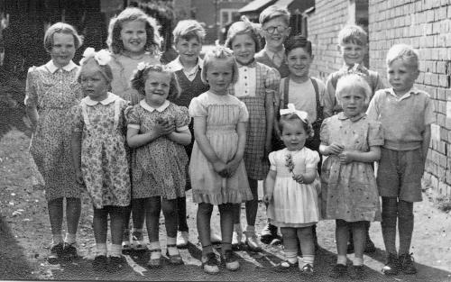
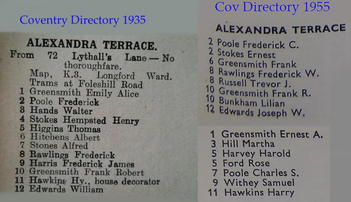
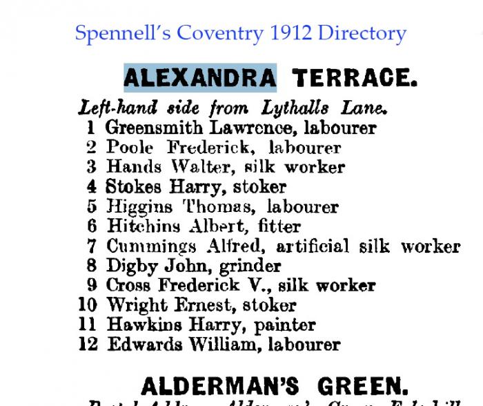
Heres a photo taken outside number 3 Alexander Terrace I think around the mid 50s. The lad at the back with the patch on his eye is Billy Poole, in front of him with the braces is David Gaut and the girl next to David I think is Jean Gaut
TCS
|
| Streets and Roads - Alexandra Terrace, Foleshill | |
|
pixrobin
Canley |
17 of 32
Sun 3rd Apr 2016 10:57pm
These types of pictures always get to me. Just think even the little girl at the front must now be in her 60s
|
| Streets and Roads - Alexandra Terrace, Foleshill | |
|
Heathite
Coventry |
18 of 32
Mon 4th Apr 2016 8:31am
|
| Streets and Roads - Alexandra Terrace, Foleshill | |
|
Heathite
Coventry |
19 of 32
Mon 4th Apr 2016 9:54am
|
| Streets and Roads - Alexandra Terrace, Foleshill | |
|
Heathite
Coventry |
20 of 32
Fri 8th Apr 2016 4:31pm
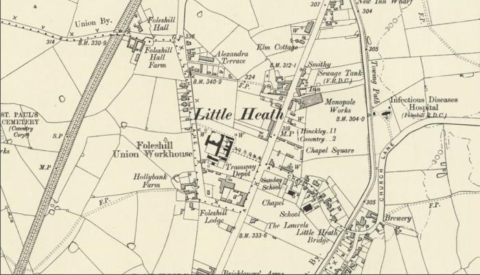
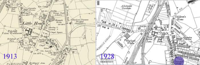
A nice clear map showing Alexandra Terrace 1928.
Edited by Midland Red, 8th Apr 2016 4:36 pm (Link clarified for ease of access) |
| Streets and Roads - Alexandra Terrace, Foleshill | |
| Ron55 |
21 of 32
Sat 23rd Apr 2016 8:29pm
|
|
Derrickarthur
Coventry |
22 of 32
Sat 23rd Apr 2016 9:53pm
On 8th Apr 2016 4:31pm, Heathite said:
A nice clear map showing Alexandra Terrace 1928.
Edited by Midland Red, 8th Apr 2016 4:36 pm (Link clarified for ease of access)
Nice map Heathite
Interesting to see that the big house in Bedlam Lane was a Children's Home in 1912. It is now an Old People's Home. The rounded shape above the letter C became known as Peggy's Pond in Peggy's Park.
Does this map show the Foleshill Workhouse (just below Foleshill Flats ?) and Chapel Square on the corner of Old Church Road (formerly Chapel Road) If so could you attach a view of this please.
Interestingly Old Church Road is designated the B 4082 and meanders to Bell Green, becomes the Henley Road, Woodway Lane and finally Clifford Bridge Road past the Hospital to the roundabout near Tesco and then bears left to the next roundabout at the A46
|
| Streets and Roads - Alexandra Terrace, Foleshill | |
|
Heathite
Coventry |
23 of 32
Sun 24th Apr 2016 8:12am
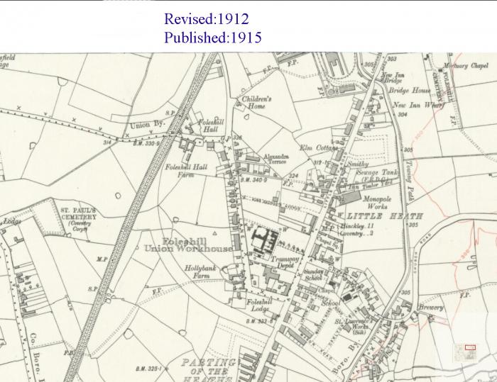
Good morning, here's what you requested methinks.
|
| Streets and Roads - Alexandra Terrace, Foleshill | |
|
johnwright
combe martim |
24 of 32
Sun 24th Apr 2016 9:11am
Thanks for the map Heathite. Is this part of a larger map? I was brought up in Parkstone Road which doesn't show on the map, in fact there are so many places which must have come later to the map, and many places on the map which have disappeared.. I was specially interested in the "Monopole Works" as I had never heard of it until a friend of mind mentioned that his father had worked there. |
| Streets and Roads - Alexandra Terrace, Foleshill | |
|
Derrickarthur
Coventry |
25 of 32
Sun 24th Apr 2016 12:23pm
Heathite. Am I correct in thinking that this latest map showing the workhouse & Chapel Square is not the same OS map (1912) that you posted earlier. Elmsdale Ave & King George's Avenue are on your 1912 OS map but not on this one which means it is pre-1912.
My Great Great Grandmother Sarah Lester died in the Foleshill Union Workhouse in 1889. The cause of death was given as Decay of Nature. She was 59.
On the map, the Workhouse looks a huge complex. I have looked on the internet and can find very limited information about this institution. I cannot find out when it closed and was demolished but it cannot have been much earlier than the 1930's. I am amazed and disappointed that there are no photographs of the original buildings.
|
| Streets and Roads - Alexandra Terrace, Foleshill | |
|
Heathite
Coventry |
26 of 32
Sun 24th Apr 2016 1:22pm
Hi Mr Arthur. If you look at the railway map you will see it is from 1928. I think the earlier map is from circa 1913. Others members may be able to correct me. |
| Streets and Roads - Alexandra Terrace, Foleshill | |
|
Derrickarthur
Coventry |
27 of 32
Sun 24th Apr 2016 2:01pm
Heathite. Sorry my mistake about dates of maps. Does the 1928 railway map show the Workhouse ? |
| Streets and Roads - Alexandra Terrace, Foleshill | |
|
Heathite
Coventry |
28 of 32
Sun 24th Apr 2016 3:15pm
 Hi.
On the maps you can see the same location. The Railway maps are brilliant but limited.
The workhouse would have been just below the flats on the 1928 map, so I can't say for certain, I may try to find a map that confirms it either way.
Hi.
On the maps you can see the same location. The Railway maps are brilliant but limited.
The workhouse would have been just below the flats on the 1928 map, so I can't say for certain, I may try to find a map that confirms it either way.
|
| Streets and Roads - Alexandra Terrace, Foleshill | |
|
Heathite
Coventry |
29 of 32
Sun 24th Apr 2016 3:48pm
On this map of 1913, if the Foleshill Union Workhouse refers to the dark cross shaped building then after this date they are referred to as Foleshill Flats.
Maybe other members know if they were using the workhouse buildings as flats instead of flattening them ?
|
| Streets and Roads - Alexandra Terrace, Foleshill | |
|
Annewiggy
Tamworth |
30 of 32
Sun 24th Apr 2016 5:53pm
From the newspaper archive site, Coventry Telegraph in May 1916. It says that the inmates were to be removed to Nuneaton Poor Law Institution at Chilvers Coton. The building was let to Messrs Mowlem & Co Ltd for the accommodation of workmen employed on the construction of a munitions factory. |
| Streets and Roads - Alexandra Terrace, Foleshill | |

Website & counter by Rob Orland © 2024
Load time: 324ms