The following is highly speculative.
As part of my ongoing exploration of Coventry's waterways and mills I found an anomaly at Charterhouse. The area south of Gosford Gate used to have many meanders that were subsequently removed. At least one was blocked up by the construction of the railway and the river channel going under the arches is quite probably new. The oldest maps chart a few of the original loops but the river in front of Charterhouse is suspiciously straight in every map I've seen. Of course the monks themselves could have created the current channel as other monks did across Coventry and it seems a roll of the dice whether the linear mill race or the original channel remained after the mills were removed. I've mentioned that I'm missing a mill and while the most likely answer is that the mill was actually the same as another mill (they had many names over the years), there is a possibility that my anomaly is the missing mill pond. Here's a map of the anomaly. It's the wiggly line starting middle left and ending with bushes/trees bottom right. Probably it's the remains of a stream bed draining off the common (now the London Road cemetery).
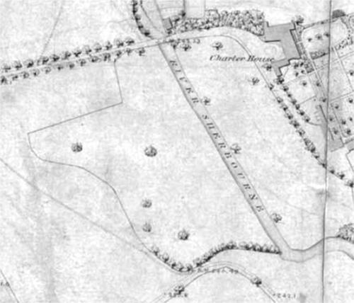
But there's another feature, the oblong nearest the lane to Charterhouse. Just a modern field boundary? Except it's visible in this aerial photo of war damage (thanks Robthu).
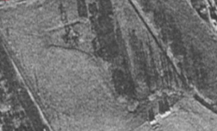
And seems to be a lower stretch of land.
So, was this a very old meander of the river that has long since silted up? There is a claim that outside Charterhouse, surrounded by water, there was a chapel for ordinary people. The current river route and an original meander (rather than a stream) could have created an island. The land on that side of the river was called St Anne's Grove.
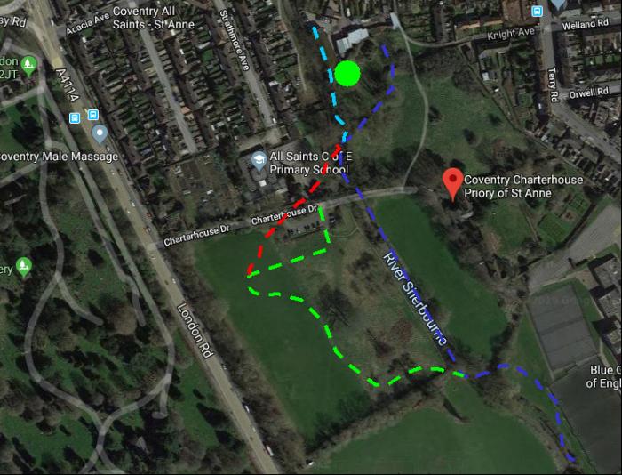
The dark blue line is the river as per my oldest map.
The pale blue line is the river feeding Charterhouse mill
The green blob is the mill location
The green line is the wiggly feature
But what is the oblong feature? If we look back at Naul's mill we might have a clue.
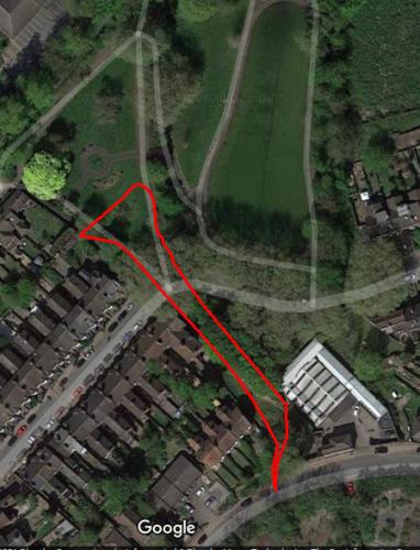
Notice the wider straight end to the pool? Water was channelled off to fill the pool, while the Radford Brook continued along its original route. The mill pond wasn't pond shaped and the mill was furthest from the straight feature. Could my anomaly be a similar thing? It would still have left plenty of space for a chapel. A mill could have been anywhere along the wiggly line before it joined the main channel. One fly in my ointment is that the land may be too high to have been fed by the river nearby and we're back to the stream idea. However, as with Naul's mill pond, water could have been tapped off further up the river where the head height worked. Most of the traces of this feature could have been silted up, ploughed out and filled with organic material. Even the land level would have risen. In the Google picture I drew in a very speculative red dotted line for a meander but water channelled off could have been well off the map to the north.
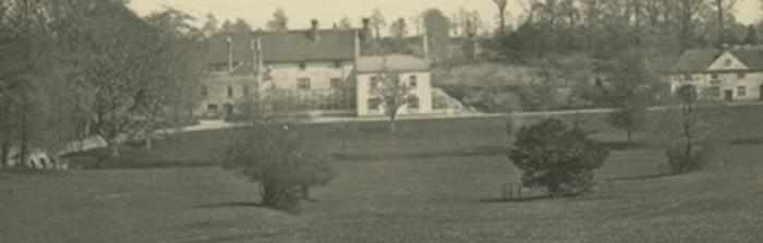
One last thought. The lower land closest to Charterhouse and next to the current river route was called The Dove House Meander. Might the river have come much closer to the buildings? Time, silting, new channels and man have left us with just guesses.

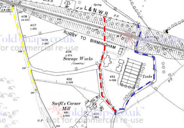
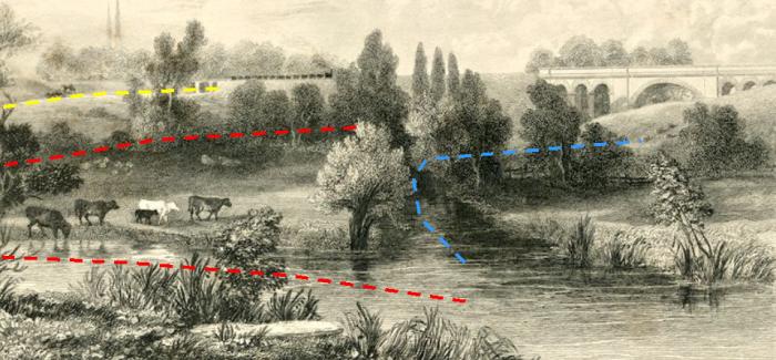 Many of you will be familiar with this image but there are details you might not be aware of. The blue branch we can see today, right next to the east side of the waste disposal plant. It was probably more naturally curved before the railway was built. The yellow line is the London Road and beyond it the southern half of the cemetary, but the red line is the now dried up branch of the Sherbourne that used to serve Swift's Corner Mill. That was probably to the left of the scene. Just on the other side of the railway line there was a tangle of channels and on the western most one was another mill, possibly Liggin's Mill although I'm not 100% sure.
 I've been struggling to imagine the mill pond and the park pool as the same place... and now I find that it's not!
 The area was a bit of a warren of streams and channels. I'm guessing that the original brook started off in Radford or beyond, followed the valley and ran just to the east of where the park pool was. When the mill was created a new stream was tapped off the brook at a height a bit above the level of the mill pond, which seems to be a bit north of the railway line. There was a sluice there. I imagine that in dry weather the old brook might be shut off altogether to serve the mill with what water there was. There was the additional sluice on the mill pond itself to relieve pressure on the pond level in an emergency. That flowed back to the brook. The feed to the mill had unnaturally sharp corners and the park paths followed them somewhat. The railway made more sharp corners.
The original Coventry streams themselves weren't left untouched and often meanders were straightened. This seems the case with the original Radford Brook as it is quite straight along the valley. Once the mill was abandoned the original stream became the primary route again and the park was set within the boundaries of the straightened brook and the mill feed channel. The park pool sits next to the stream (as you indicate probably underground now) and was maybe fed by another sluice? Although it might now be filled with drinking water?
I think that most of the oldest paths followed the water.
The area was a bit of a warren of streams and channels. I'm guessing that the original brook started off in Radford or beyond, followed the valley and ran just to the east of where the park pool was. When the mill was created a new stream was tapped off the brook at a height a bit above the level of the mill pond, which seems to be a bit north of the railway line. There was a sluice there. I imagine that in dry weather the old brook might be shut off altogether to serve the mill with what water there was. There was the additional sluice on the mill pond itself to relieve pressure on the pond level in an emergency. That flowed back to the brook. The feed to the mill had unnaturally sharp corners and the park paths followed them somewhat. The railway made more sharp corners.
The original Coventry streams themselves weren't left untouched and often meanders were straightened. This seems the case with the original Radford Brook as it is quite straight along the valley. Once the mill was abandoned the original stream became the primary route again and the park was set within the boundaries of the straightened brook and the mill feed channel. The park pool sits next to the stream (as you indicate probably underground now) and was maybe fed by another sluice? Although it might now be filled with drinking water?
I think that most of the oldest paths followed the water.
