Robthu
Coventry
|
16 of 78
Sun 20th Apr 2014 8:02pm
On 20th Apr 2014 2:48pm, nevis42 said:
So glad I found this site  . Does anyone have photos of the old cottages which once stood on Hill street? Apparently my grandfather once lived in one of them. I am also looking for plot number 160 in London road cemetary but cannot find its location. Many thanks... 
I have found a Williamson in GRAVE 160 SQUARE 94/95 will this help. |
|
Streets and Roads -
Hill Street
|
TonyS
Coventry
|
17 of 78
Sun 20th Apr 2014 10:10pm
I believe the Williamson reference was made in the first post by "brummiebelle" - and is not connected to nevis42 (what a coincidence though!)
For brummiebelle, here is the approximate location of the grave that robthu has found:
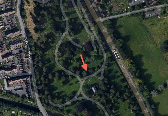 Image
Image |
|
Streets and Roads -
Hill Street
|
nevis42
bedworth
|
18 of 78
Mon 21st Apr 2014 12:13pm
Thankyou to all the help so far . I shall go to the cemetery and see if there is a gravestone for John Gutteridge. The photos will help me pinpoint the location  |
|
Streets and Roads -
Hill Street
|
|
Annewiggy
|
19 of 78
Thu 24th Apr 2014 11:20am
|
|
mickymatic
Market Deeping
|
20 of 78
Wed 1st Apr 2015 10:42am
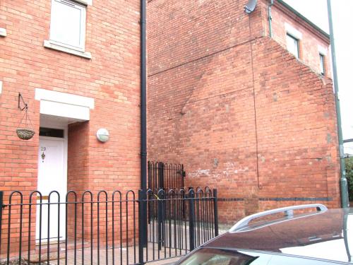
I wonder if anybody can help me.
The attached picture, taken in 2012, shows the end wall of a cottage in Hill Street, similar in size to the buildings that stand opposite.
In 1851 my great great great grandmother (Elizabeth Moore) lived at 31 Hill Street. My thought is that if this is not the remains of 31 Hill Street it's awfully close!
Does anyone know either where 31 Hill Street was in relation to the current buildings, or advise me on how I can find out?
Many thanks for your help.
Mick
 |
|
Streets and Roads -
Hill Street
|
Midland Red
|
21 of 78
Wed 1st Apr 2015 11:01am
Hi Mick and welcome to our forum
That's a really interesting post, and I do hope someone can assist you - let's hope so, as I'm sure many would like to see the answers  |
|
Streets and Roads -
Hill Street
|
NormK
bulkington
|
22 of 78
Wed 1st Apr 2015 11:09am
Mick. It looks to me it was in the gap in your pic, there is an outline on the wall where another building once stood.
|
|
Streets and Roads -
Hill Street
|
Helen F
Warrington
|
23 of 78
Wed 1st Apr 2015 11:25am
Most Coventry streets were not numbered odd and even on opposite side of the road but consecutively so 31 would have been the one beyond the gap or in the big gap to the left if that is the way the numbering runs. However numbering has changed slightly over the years so without calculating it's hard to say if this is the same 29 as 1851. |
|
Streets and Roads -
Hill Street
|
TonyS
Coventry
|
24 of 78
Wed 1st Apr 2015 11:56am
Relating to Helen's reply (above) it's perfectly possible that Hill Street was completely renumbered, but currently properties run odds on this side and evens on the other.
Sadly I can't explain the "shadow" roof-line, but looking at an old map of the area, there appears to have always been a shared passageway between the two houses in your pic, in which case that would make No 31 the bay-fronted house in your photo (which is the one to the right of the gap - just hidden by the projecting wall). |
|
Streets and Roads -
Hill Street
|
Helen F
Warrington
|
25 of 78
Wed 1st Apr 2015 12:25pm
After looking it up. The White Swan was originally number 1 and the Newdigate Arms was number 11 which is consistent with consecutive numbering. That would have made the north corner of Bond street number 14 (edited to remove mistake). If you get a copy of the Board of Health Map for Hill Street you could count each house until you get to number 31. If you get to the end of Hill street you then start counting back towards the city. Even identifying the last house is sometimes hard.
There's a difference between the Swindlehurst map on this site and the Board of Health map so you need to see the older one which is dated 1850. Copies can be viewed or photocopied from the Herbert History Centre. If you can work out where it was, there might be an image of it. An alternative is to look up nearby business numbers on that street and see if there's something identifiable on the map (eg a wood yard). Sorry it's not an easy solution. |
|
Streets and Roads -
Hill Street
|
Annewiggy
Tamworth
|
26 of 78
Wed 1st Apr 2015 12:33pm
Looking at the census the numbers are consecutive. 34 to 29 Hill Street census is between Gas Street and Riley Street which would make them on the East side. (as long as the enumerator did them in order)  |
|
Streets and Roads -
Hill Street
|
Annewiggy
Tamworth
|
27 of 78
Wed 1st Apr 2015 1:22pm
Just found this:
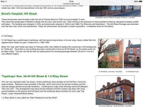
Confusing though, it says constructed 1890-1905. I have also looked at old maps and pictures of Leigh Mills and where I think the numbers are would have been in front of that. On various pictures of Leigh Mills on line it looks as if there are a row of top shops on the Hill Street side. |
|
Streets and Roads -
Hill Street
|
Helen F
Warrington
|
28 of 78
Wed 1st Apr 2015 1:42pm
If they were built in 1890 it would explain why there's a difference on the 1850 map. To make matters even more confusing, Hill Street was one of those streets that was quite empty in 1750 but had previously been and was latterly populous. How many times did the numbering change... or indeed, when did it start?
If the plot count (ie counting 31 from White Swan) remained the same, I would say that number 31 was the leftmost of the block in Anne's third picture (number 44), before the pub The Gatehouse Tavern. Currently the Irish Society's building.
 |
|
Streets and Roads -
Hill Street
|
Annewiggy
Tamworth
|
29 of 78
Wed 1st Apr 2015 2:38pm
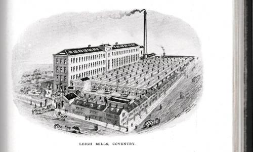
Those houses and the gate house look like the same ones that are in the picture of Leigh Mills in my 1896 book. That was built in about 1863. Now are they houses that were originally there and incorporated in the mill or were they built when the factory was? I think the 31 in the article before is after the number were changed to alternate numbers. The numbering I found was from the 1881 census.
|
|
Streets and Roads -
Hill Street
|
Midland Red
|
30 of 78
Wed 1st Apr 2015 2:59pm
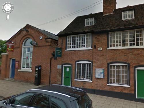
On 1st Apr 2015 1:42pm, Helen F said:
If they were built in 1890 it would explain why there's a difference on the 1850 map. To make matters even more confusing, Hill Street was one of those streets that was quite empty in 1750 but had previously been and was latterly populous. How many times did the numbering change... or indeed, when did it start?
If the plot count (ie counting 31 from White Swan) remained the same, I would say that number 31 was the leftmost of the block in Anne's third picture (number 44), before the pub The Gatehouse Tavern. Currently the Irish Society's building.
Here's another view from a different angle
|
|
Streets and Roads -
Hill Street
|

