
|
Kaga simpson
Peacehaven, East Sussex |
136 of 229
Sun 31st Dec 2017 11:35am
Well the Sherbourne played its part during the war for the water from it saved most of the Burges and old Palmer Lane and much more |
| Town Planning and Development - River Sherbourne | |
|
PhiliPamInCoventry
Holbrooks Thread starter
|
137 of 229
Tue 13th Mar 2018 10:51am
A vision for our river.
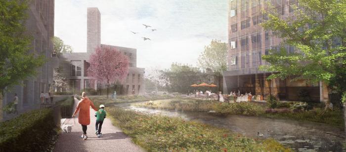 Strictly, this bit might still be Radford Brook, but flows into the Sherbourne around here.
|
| Town Planning and Development - River Sherbourne | |
|
ron osmond
hinckley |
138 of 229
Thu 29th Mar 2018 2:18pm
I lived in Riverside Close, Whitley in the late 1960's, and the Sherborne ran deep and narrow at the bottom of our garden. Over the river was Coventry Zoo, so we had a pretty unique view of wild animals each morning as we woke up (as well as a unique smell!). One day we looked out and saw the mighty Zulu warrior gazing at us. The zoo was doomed, though, with plans for the new elevated by-pass. ron osmond
|
| Town Planning and Development - River Sherbourne | |
|
Harrier
Coventry |
139 of 229
Tue 10th Dec 2019 11:52am
Over the last couple of weeks as a result of all the heavy rain, the level of the river Sherbourne in Allesley has fluctuated widely. However, for three weeks now the Sherbourne has had two regular visitors on the stretch of the river between the Townfield Saddlers in Butt Lane and Streamside Close, off Washbrook Lane. Here the river is narrow and confined by the banking. This has not deterred a kingfisher darting up and down on his regular visits while taking a much more leisurely stroll, is an egret, neither seemingly too worried by the traffic or humans. I assume the increased river flow must be providing the sustenance?? |
| Town Planning and Development - River Sherbourne | |
| PeterB |
140 of 229
Tue 10th Dec 2019 9:08pm
|
|
Kaga simpson
Peacehaven, East Sussex |
141 of 229
Sun 10th May 2020 10:54am
Dreamtime
Post 46 on this topic you will find Colin's Cornucopia, well worth anyone's read. |
| Town Planning and Development - River Sherbourne | |
|
Dreamtime
Perth Western Australia |
142 of 229
Sun 10th May 2020 5:54pm
Kaga, thank you I had read it before and I well remember the last time in 1960 of the flooding. I was still living at the Broomfield Tavern then and by 1961 married and lived in Lincroft Cres. - a hop skip and a jump to the Sherbourne Fields Allotments. Always remembered how green it was over there and further still was the Holyhead Road. Happy days. |
| Town Planning and Development - River Sherbourne | |
|
Disorganised1
Coventry |
143 of 229
Sun 10th May 2020 11:46pm
Used to occasionally see a kingfisher up by the pond. A flash of blue, and he was gone.
Sadly the water table has been decimated by the road built to the back of the old Brown's Lane plant, and the extensive tarmacing done by Amazon since.
The promised work on the drainage and clearance was never done, though they did tidy things up a bit in 2018 after the floods in Butt Lane. |
| Town Planning and Development - River Sherbourne | |
|
Kaga simpson
Peacehaven, East Sussex |
144 of 229
Mon 11th May 2020 10:57am
I believe the Sherbourne was a clean river two centuries ago, there were few houses around Spon End, and those there had fishing rights so would keep it clean. No railways, cars, papers, cigarette packets, bike parts, mainly fields and mills. A fast flowing stream that would carry all before it, A miller would know the weight and force of water needed to x amount of hours he could work. By the time it reached Hales St it was double the force, nicknamed the 'Severn' it was known as fast flowing, so why call it a dirty river? Constantly flooding, it would sweep all before it to the mill. We know the mill pools were shallow, dragged often, we hear of little pollution, the water on the move constantly. |
| Town Planning and Development - River Sherbourne | |
|
Helen F
Warrington |
145 of 229
Mon 11th May 2020 1:21pm
You're right Kaga, there was probably very little solid pollution as people threw away very little. Even tree branches would be collected because they were free fuel. Invisible pollution is another matter. There were rules about the river but it's hard to know how successful they were. Almost certainly most street drains emptied into the river. While people had a requirement to keep the street in front of their property 'clean' that would have just involved lumps. Probably the early factories also emptied stuff into the river. By and large drinking water was sourced from deep wells and piped supplies from the hills surrounding the city. The citizens used the river water to wash clothes. There is at least 1 point marked 'washing point' near Cross Cheaping in 1850.
'Fast flowing' yes, I've read the same and I'm not sure what it means. How fast is 'fast'? There is evidence that suggests the country used to see a lot more rain than we've had until the recent flooding years. Suggesting that we are returning to normal, not seeing a new effect. That might well explain part of the issue. With the changes since 1800 there has been a lot of water diverted for one thing or another. Several streams were redirected from the north when they built the canal. Modern sewers deal with other flows that used to head towards the city. There was also the mills themselves. Their ponds would collect water for when the mills were in operation, so maybe the released was low at night but vigorous during the day when people observed the flow? The mills would operate in sequence so that even mills with no pond would get a decent flow when the mill up river was running? If Naul's Mill and Spon End Mill were operating at the same time the Sherbourne at the Priory Mill would have been plentiful, even without their own pond.
There are several references to the city flooding and in theory there was at least one large lake back in Roman times. Coventry is a soggy place.
Colin's Cornucopia is a very useful site. |
| Town Planning and Development - River Sherbourne | |
|
Helen F
Warrington |
146 of 229
Fri 5th Jun 2020 5:52pm
Something to add to the pictures of the Sherbourne route in Colin's Cornucopia
Coventry Telegraph pics |
| Town Planning and Development - River Sherbourne | |
|
SJT
Brisbane, Australia |
147 of 229
Thu 2nd Jul 2020 1:11am
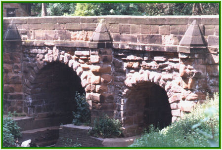
I'm after the name of a bridge in Coventry and wondering if anyone can help. If a man (a weaver) was to walk from Spon End towards the city centre in 1831 what bridge over the Sherbourne would he cross? I saw this photograph on Colin's Cornucopia and wondered if it might be this one and if so, is that the right name for it? Spon Street Bridge or maybe Spon Gate Bridge? Thanks in advance for any help you can provide.
 |
| Town Planning and Development - River Sherbourne | |
|
Midland Red
|
148 of 229
Thu 2nd Jul 2020 8:09am
It's known as Spon Bridge, linking Upper Spon Street with Spon End  Historic England listing
 |
| Town Planning and Development - River Sherbourne | |
|
Kaga simpson
Peacehaven, East Sussex |
149 of 229
Thu 2nd Jul 2020 9:11am
MR
Same book says, the river is spoken of in old deeds and old plans as the Spon Brook, a causeway for foot passengers was built in the year 1607. Spon Bridge wasn't erected until 1767 after a big flood.
You tell me what to believe, I'm getting too old for this.
'Beam me up, Scotty' |
| Town Planning and Development - River Sherbourne | |
|
Helen F
Warrington |
150 of 229
Thu 2nd Jul 2020 9:56am
SJT If your man walked all the way into town, he would have crossed the Sherbourne again at the Ram Bridge (where Fleet Street meets Smithford Street). The picture below is 1819ish.
 Kaga, again, I'm not sure that the book is wrong. The current bridge and causeway aren't as old as we might think and are said to be built out of the stone from both the Coventry Cross and the Spon Gate. The causeway is due to the dip down to the river on both sides. They built the ground up to the two sides so the road carries on level. However, it would have been there for SJT's man to cross.
Prior to that bridge, there was a ford and small bridge for light use. So large wagons would have to use the ford when the water level permitted but lighter, single file travellers and their animals could use the small bridge.
Kaga, again, I'm not sure that the book is wrong. The current bridge and causeway aren't as old as we might think and are said to be built out of the stone from both the Coventry Cross and the Spon Gate. The causeway is due to the dip down to the river on both sides. They built the ground up to the two sides so the road carries on level. However, it would have been there for SJT's man to cross.
Prior to that bridge, there was a ford and small bridge for light use. So large wagons would have to use the ford when the water level permitted but lighter, single file travellers and their animals could use the small bridge.
|
| Town Planning and Development - River Sherbourne | |

This is your first visit to my website today, thank you!
3,319,865Website & counter by Rob Orland © 2024
Load time: 38ms