
|
Rob Orland
Historic Coventry |
121 of 163
Tue 19th Apr 2022 10:14am
I've always been rather bemused by the orientation of this woven map - as wonderful as it is. The city seems to be roughly correctly oriented north-top - south-bottom, whereas the satellite villages (now all part of Coventry, of course) are swivelled around anticlockwise, so east is at the top and west at the bottom!
I think we'd all love to know what was in the mind of the makers, though.... did they add the features, like spires, etc. because of what had been passed down to them - or did they depict the things that they thought a city like Coventry should have had? (Or a bit of both!) |
| Local History and Heritage - Maps of Coventry | |
|
Helen F
Warrington |
122 of 163
Tue 19th Apr 2022 10:20am
Yes, it confused me Rob, when I first saw the tapestry segment. I think it ties in with the makers joining different maps together. The wider maps are by Saxton, I think, but the city maps wouldn't have been redrawn to be in the correct orientation or scale for the rest. They just stuck them in.
The city bit is drawn the way Coventry is often drawn, looking at Greyfriars Gate in the foreground with the church behind. St John's to the left and I think it's London Road and New Gate to the right. Half the city is missing because it's over the hill. St Mary just peeps over because it was tall. I think. |
| Local History and Heritage - Maps of Coventry | |
|
Annewiggy
Tamworth |
123 of 163
Tue 19th Apr 2022 10:22am
Yes Rob, I was trying to find where Radford would have been but I was completely thrown with Allesley being to the south of the map. |
| Local History and Heritage - Maps of Coventry | |
|
Helen F
Warrington |
124 of 163
Tue 19th Apr 2022 10:57am
Below are zoomed pictures of what I think are St Michael's (corrected), St John's and Greyfriars, complete with grey/whiteish roofs on the main body of the churches (not to be confused with the blue of the river snaking round the back in the first image). These are clearly only suggestions of buildings, as are the houses, not an attempt to recreate the true view. In the first picture of St Michael's (corrected) there are two more 'spires'. The one to the right might be the Bastille Gate but the one to the left looks suspiciously like it's in the location of St Mary's centre crossing point. Note the almost witch’s hat shape, not uncommon. It's possible that Greyfriars spire got a church by mistake on the part of the weavers but what are all those extra spires? If as I suggest the city was drawn as seen from the south, what else but St Mary's could be seen over the hill? Heavy speculation but interesting.
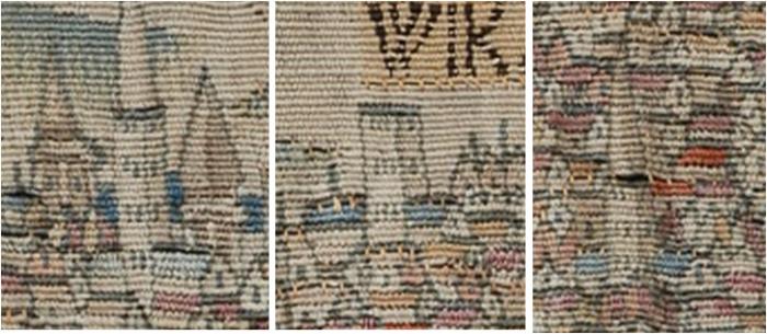 Correction - first church is St Michael's.
 |
| Local History and Heritage - Maps of Coventry | |
|
Helen F
Warrington |
125 of 163
Wed 20th Apr 2022 5:05pm
In the last post I didn't get St Michael's in the right place, partly because the order of the spires change as you move round the city but also because in the oldest of images it doesn't have the distinctive top with buttresses. This may be because it was too difficult to see the detail or recreate it or because it might have been physically different originally. Once St Mary's, Greyfriars and Whitefriars were demolished there might have been a lot of fancy stonework up for grabs. Repairs or embellishments might have seen St Michael's acquire some of its more iconic bits or just replace sections that were almost dissolved away. On the tapestry it's hard to work out what is roof.
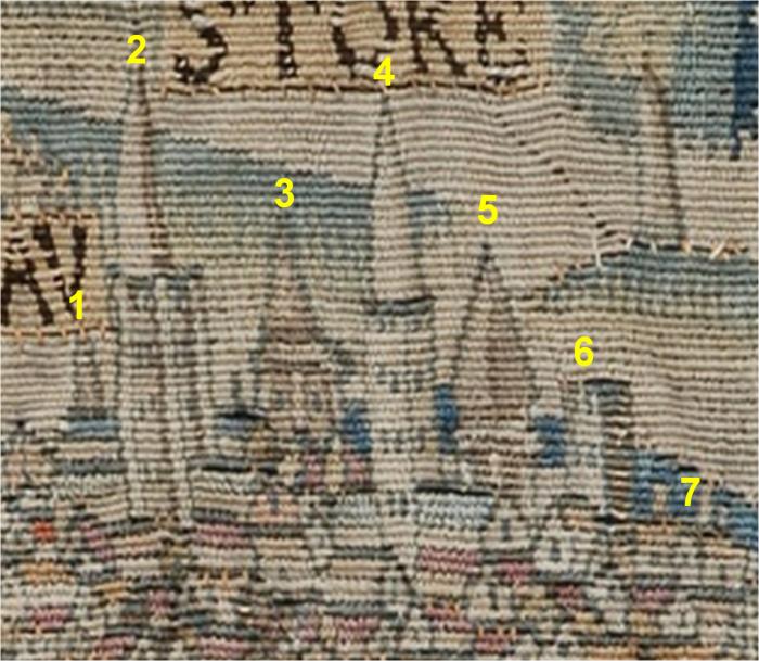 (1) Not at all sure what this 'spire' is. Could it be one of the front towers of St Mary? The Cross? St Nicholas?
(2) Holy Trinity
(3) This looks the right position for St Mary's central crossing. I couldn't line it up as being the front tower position of St Mary's but I can't guarantee that it's not.
(4) St Michael’s
(5) This could be the Bastille/Earl's Mill Gate or even the Gosford Gate but neither seems tall enough to feature on this cameo of the city. They'd fit better as (6)
(1) Not at all sure what this 'spire' is. Could it be one of the front towers of St Mary? The Cross? St Nicholas?
(2) Holy Trinity
(3) This looks the right position for St Mary's central crossing. I couldn't line it up as being the front tower position of St Mary's but I can't guarantee that it's not.
(4) St Michael’s
(5) This could be the Bastille/Earl's Mill Gate or even the Gosford Gate but neither seems tall enough to feature on this cameo of the city. They'd fit better as (6)
 A better possibility is that it might have been a tower on the apse of St Mary's, which was supposed to have cupolas (domes).
 In a depiction of St Mary's part way through demolition the central tower looks like it might have been octagonal. Might an apse cupola been similar? Very, Very speculative.
(6) This does look like a wall tower or gate.
(7) The river.
Another thing that repeatedly throws me over the order of the spires is the relative heights. Part of this can be explained by distance to the artist, so Greyfriars may appear the tallest.
Relative heights discussed before.
In a depiction of St Mary's part way through demolition the central tower looks like it might have been octagonal. Might an apse cupola been similar? Very, Very speculative.
(6) This does look like a wall tower or gate.
(7) The river.
Another thing that repeatedly throws me over the order of the spires is the relative heights. Part of this can be explained by distance to the artist, so Greyfriars may appear the tallest.
Relative heights discussed before. |
| Local History and Heritage - Maps of Coventry | |
|
Rob Orland
Historic Coventry |
126 of 163
Thu 21st Apr 2022 10:44am
Hi Helen. Although the order of spires you put above seems to be the most logical, I have a feeling that there's more than just a little artistic license going on in this image. (No sugar Sherlock, I hear you say!  )
I now have a feeling that the view might be as though seen more from south-south-east, or even more south-east-ish, placing the spire of St. Michael's (number 2) to the left of Trinity's - greatly exaggerated by their separation in this view. The main reason I think this, is because I've only just noticed that, stylistically, the tower on the left appears to have the corner buttresses running its whole height - the nearest one to us in this image still, to this day, contains the spiral staircase. It would also make it likely that the artist did, at least, try to depict the correct relative spire heights.
Number 3 could still be, as you suggest, the central tower/spire of St. Mary's.... or, bearing the possible new angle in mind, be one of its western end spires, making 5 the central one? Or, with 3 retaining its central spire status, could they be depicting number 5 as being farther to the south-east than it looks..... the spire of Whitefriars Church??? Then 6 could be Gosford Gate! Oh dear, my head is spinning like a weather cock! )
I now have a feeling that the view might be as though seen more from south-south-east, or even more south-east-ish, placing the spire of St. Michael's (number 2) to the left of Trinity's - greatly exaggerated by their separation in this view. The main reason I think this, is because I've only just noticed that, stylistically, the tower on the left appears to have the corner buttresses running its whole height - the nearest one to us in this image still, to this day, contains the spiral staircase. It would also make it likely that the artist did, at least, try to depict the correct relative spire heights.
Number 3 could still be, as you suggest, the central tower/spire of St. Mary's.... or, bearing the possible new angle in mind, be one of its western end spires, making 5 the central one? Or, with 3 retaining its central spire status, could they be depicting number 5 as being farther to the south-east than it looks..... the spire of Whitefriars Church??? Then 6 could be Gosford Gate! Oh dear, my head is spinning like a weather cock! |
| Local History and Heritage - Maps of Coventry | |
|
Helen F
Warrington |
127 of 163
Thu 21st Apr 2022 5:54pm
I agree Rob and that's why I first thought that Holy Trinity was the featureless tower but there's another way of looking at the towers. Holy Trinity may have been originally blonde sandstone as far as I can gather. St Michael's was always red sandstone. I wonder, if from a distance, the bands of windows with gaps either side on Holy Trinity looked more like it had stairwells up each edge? The levels of carvings and tracery varied over the years, especially as they eroded.
Grasping at straws somewhat but look below at the righthand, sunward side of the two spires. See how St Michael's features are more of one tone?
To get the spires to change places you have to be further east than New Gate, which could well be the case for the very old sketch. The boxy nature of the gate towers in that sketch suggests it might well be New Gate. New Gate and Greyfriars Gate were the only ones on the south with buildings outside. If viewed from London Road it would put Greyfriars off to the picture to the left and the one on the right could be Whitefriars. It would also explain why St John's was almost in line with the gate.
I think that there is enough evidence to say that the tapestry image of the city wasn't just random spires and might be a pre demolition view of the city?
Yes, it does your head in trying to work out what the images are trying to say. It might one day drive me mad... woopse too late. |
| Local History and Heritage - Maps of Coventry | |
|
moriarty
allesley park coventry |
128 of 163
Fri 22nd Apr 2022 1:22pm
Wow, the tapestry does appear to show one of the earliest images of Coventry as it still has the roof structure on the priory towers (witches hats!).
I see it's the south prospect of the city, looking north.
You can make out Christ Church, St John's and Bablake but then it gets a bit complicated as Holy Trinity seems to be the wrong side of St Michael's.
However if you expand the image in 120, you see Holy Trinity spire doesn't fit exactly on top of the tower. Now this could be just the way the image was taken or they were crap at sewing (but I think they were skilled workers and this was because the church, Holy Trinity, was actually behind the tower).
This now makes the church appear behind St Michael's as it should be and the cross also aligns with Cross Cheaping.
Now all that fits nicely except you have a massive tower just In front of St Michael's, right in the middle of Bayley Lane. Now, I wonder, could it be *************? |
| Local History and Heritage - Maps of Coventry | |
|
Helen F
Warrington |
129 of 163
Fri 22nd Apr 2022 1:32pm
Hi moriarty  The fly in my ointment is the apparent swap of Holy Trinity and St Michael's. My argument as to why that might be is somewhat weak. See above.
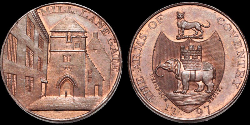
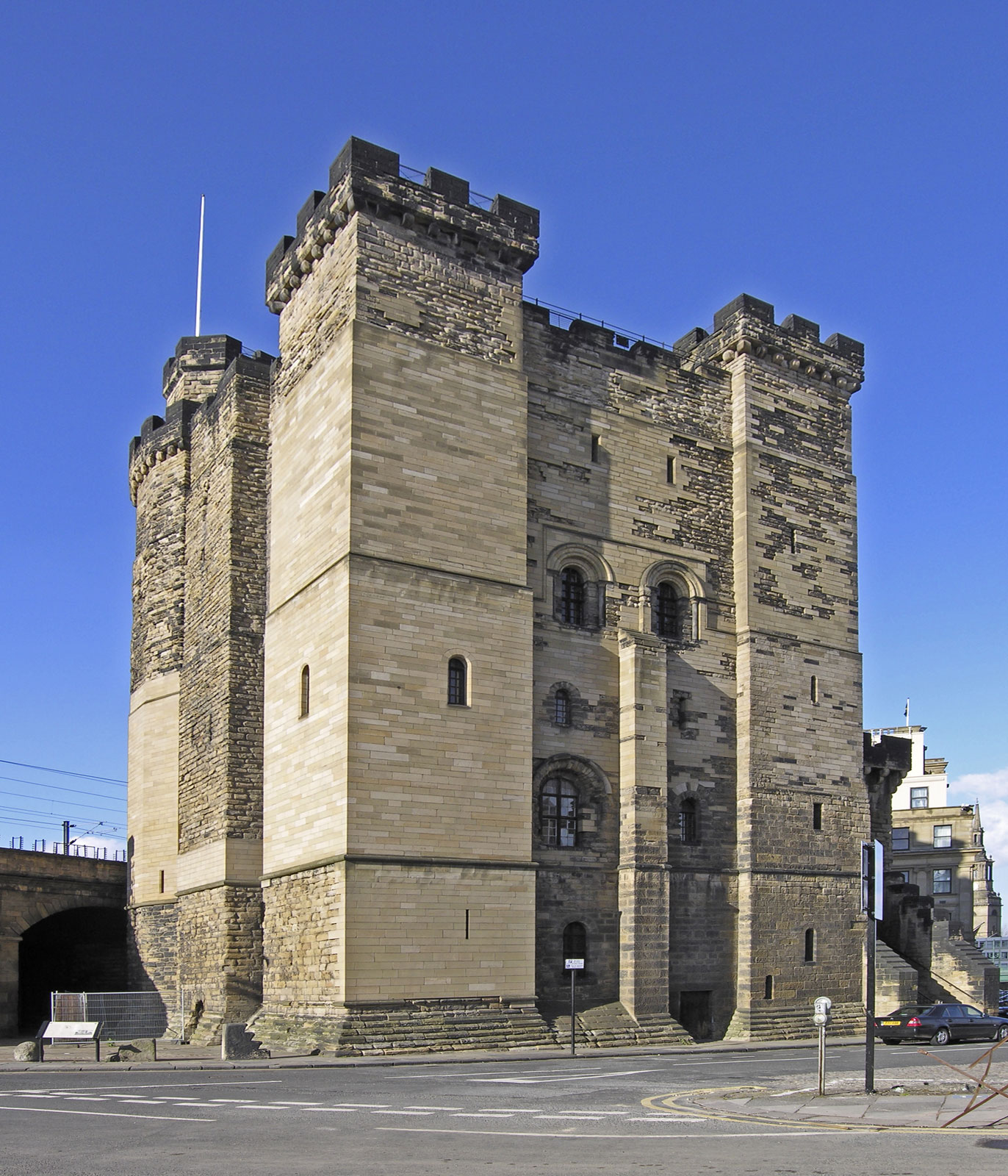
Ahhh, I see what you mean, you think the tower might be a remnant of the castle? Hmmm, certainly possible. My theory is that the keep might have been reused as the prison. It might well have had distinct corner stairwells/towers and been of a size that could be seen from a distance. I'll go test the alignments. Ohhh exciting! A bit like this image of Newcastle keep/prison. The fly in my ointment is the apparent swap of Holy Trinity and St Michael's. My argument as to why that might be is somewhat weak. See above.
Ahhh, I see what you mean, you think the tower might be a remnant of the castle? Hmmm, certainly possible. My theory is that the keep might have been reused as the prison. It might well have had distinct corner stairwells/towers and been of a size that could be seen from a distance. I'll go test the alignments. Ohhh exciting! A bit like this image of Newcastle keep/prison.
 So I just checked and yes it would explain the offset of Holy Trinity spire to the tower. It then might make number 6 part of the Bishop's Palace or the Bastille prison. St Mary's front towers would have been obscured by the same alignment.
  |
| Local History and Heritage - Maps of Coventry | |
|
Dreamer58
Coventry |
130 of 163
Mon 25th Apr 2022 5:51pm
On 19th Apr 2022 10:22am, Annewiggy said:
Yes Rob, I was trying to find where Radford would have been but I was completely thrown with Allesley being to the south of the map.
This reminds me of the view of the city centre from the top of Winsford Avenue, Allesley Park. |
| Local History and Heritage - Maps of Coventry | |
|
Helen F
Warrington |
131 of 163
Mon 25th Apr 2022 9:10pm
I can't find a bigger bit of the tapestry but it must be roughly east at the top. |
| Local History and Heritage - Maps of Coventry | |
|
Annewiggy
Tamworth |
132 of 163
Mon 25th Apr 2022 9:54pm
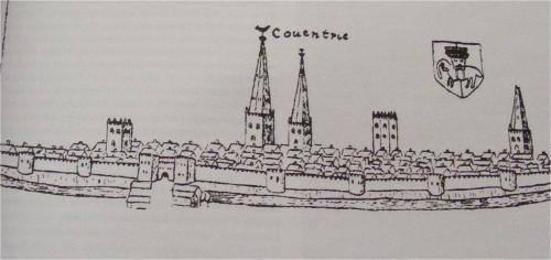
There is a large version of the Sheldon map here. It is not very easy but Tamworth is shown to the left of the map and Coventry over to the right a little higher. I do known that Tamworth is north of Coventry so yes, Helen, the top of the map is east. |
| Local History and Heritage - Maps of Coventry | |
|
moriarty
allesley park coventry |
133 of 163
Tue 26th Apr 2022 8:24am
Apologies, I earlier said the map was south prospect looking north. I subsequently looked up the Sheldon tapestry and the earlier version it was based on, as I was interested in the block house shape to the right of the map and it clearly states 2 of the maps (Warwickshire) has north at 9 o’clock. They don't know why this is so. Interestingly, the earlier Sexton map has Allesley correctly placed.
However, I thought logically (probably the wrong word!) they would have picked out all the religious sites in Coventry because it would be the most important thing at that time.
So the block house would be Whitefriars bell tower. Of course I didn't realise at the time north was at 9 o’clock so it was too far north, but if the map now moves round, it could be. |
| Local History and Heritage - Maps of Coventry | |
|
Helen F
Warrington |
134 of 163
Tue 26th Apr 2022 9:44am
Hi moriarty  The view of Coventry is most likely the south prospect looking north, it's the overall map that is at 9 o'clock. The odd orientation is probably because they wanted to use the greater width to represent north/south. Like deciding to print portrait or landscape to make the most of the paper. Since they didn't resurvey places like Coventry they didn't have a view looking east. The view of Coventry is most likely the south prospect looking north, it's the overall map that is at 9 o'clock. The odd orientation is probably because they wanted to use the greater width to represent north/south. Like deciding to print portrait or landscape to make the most of the paper. Since they didn't resurvey places like Coventry they didn't have a view looking east. |
| Local History and Heritage - Maps of Coventry | |
|
moriarty
allesley park coventry |
135 of 163
Tue 26th Apr 2022 10:45am
Yes Helen, you could be right about that.
I think you would need to overlay a few maps on a computer and manipulate the image/also the Sheldon tapestry. Although it's been conserved earlier, looks tired and faded. I’m sure there is an app which could be used to enhance the image, you might see a lot more
It’s all too complicated for me, I'm having trouble changing the brake blocks on my pushbike! Bye. |
| Local History and Heritage - Maps of Coventry | |

Website & counter by Rob Orland © 2024
Load time: 26ms