
|
Davey
Coventry |
121 of 234
Tue 19th Apr 2016 10:07pm
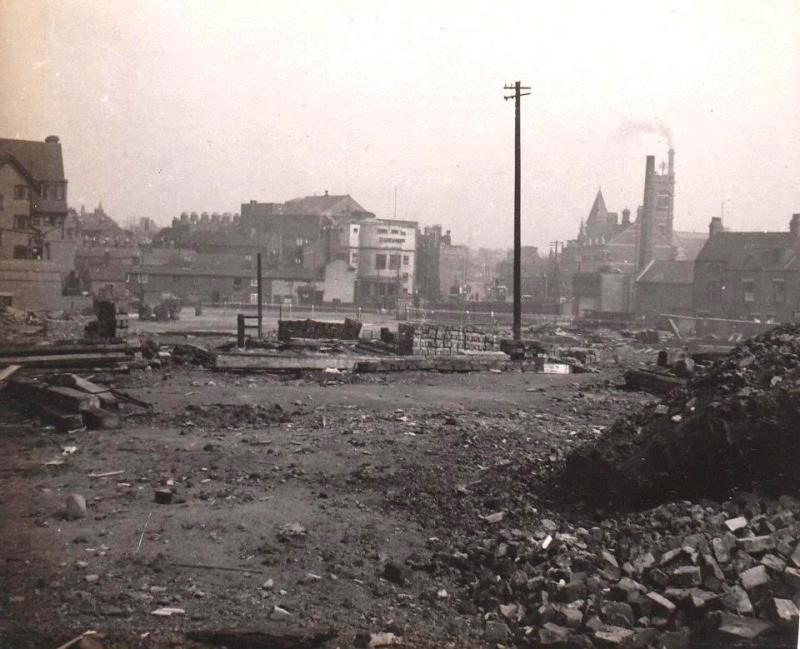
Is this where we're talking about? Taken by my grandad, not sure when.
DavidT
|
| Town Planning and Development - River Sherbourne | |
|
dutchman
Spon End |
122 of 234
Tue 19th Apr 2016 10:15pm
Sort of Davey, those are the remnants of Smithfield Market which was demolished to make way for the building of Trinity Street which opened in 1937. And thank you for posting the picture
 |
| Town Planning and Development - River Sherbourne | |
|
mcsporran
Coventry & Cebu |
123 of 234
Mon 7th Nov 2016 4:48pm
The Sherbourne viaduct in 1837. Was it ever really that picturesque? |
| Town Planning and Development - River Sherbourne | |
|
dutchman
Spon End |
124 of 234
Tue 8th Nov 2016 7:29pm
I'm pretty sure it's the Sowe Viaduct:
Sowe Viaduct, near Binley, 2 July 1837
|
| Town Planning and Development - River Sherbourne | |
|
Midland Red
|
125 of 234
Fri 17th Feb 2017 9:12am
Red sludge contamination - report  |
| Town Planning and Development - River Sherbourne | |
|
Helen F
Warrington |
126 of 234
Thu 10th Aug 2017 3:27pm
Looking at this partial map (after William Hole c.1540-1610, a map of Warwickshire, hand-coloured engraving, published for Michael Drayton's Poly-Olbion), it shows the Cune as separate from the Sherborn (spelling as per the map). The Cune seems to be the river starting in the west beyond Spon End and the Sherborn started in the north of the city and joined the Sowe before meeting the Cune south of the city.
 I do have a theory that more water used to flow from the north to explain why there was the Babu Lacu. Swanswell lake partly comes from a spring but that joins a stream coming from the north. If some enterprising monks kicked the course of the Sherborn to join the Sowe further north it might explain why the lake slowly dried up. It's also possible that it rained more then and all the rivers were stronger flowing or that the outflow of the lake was more impeded.
|
| Town Planning and Development - River Sherbourne | |
|
NeilsYard
Coventry |
127 of 234
Sun 20th Aug 2017 12:43am
I'd not seen this 'painting' before but love the image of the bridge over the Sherbourne....

|
| Town Planning and Development - River Sherbourne | |
|
Dreamtime
Perth Western Australia |
128 of 234
Sun 20th Aug 2017 3:11am
Another winner Neil, thank you. A great picture, livestock and all. |
| Town Planning and Development - River Sherbourne | |
|
Midland Red
|
129 of 234
Sun 20th Aug 2017 8:15am
On 20th Aug 2017 12:43am, NeilsYard said:
I'd not seen this 'painting' before but love the image of the bridge over the Sherbourne....
Yes, it's a brilliant image
It did appear in the Old Cathedral thread:
On 22nd Aug 2014 11:01pm, AD said:
When I clicked the links one showed this.
That says it's from Priory St and HT should be in front.
|
| Town Planning and Development - River Sherbourne | |
| Dreamtime |
130 of 234
Sun 20th Aug 2017 12:42pm
|
| Midland Red |
131 of 234
Sun 20th Aug 2017 1:14pm
|
|
mcsporran
Coventry & Cebu |
132 of 234
Sun 20th Aug 2017 2:53pm
On 10th Aug 2017 3:27pm, Helen F said:
The Cune seems to be the river starting in the west beyond Spon End and the Sherborn started in the north of the city and joined the Sowe before meeting the Cune south of the city.
According to this page the Cune was an early name for the Sherbourne, but neither the map nor the CET is a very trustworthy source. |
| Town Planning and Development - River Sherbourne | |
|
walrus
cheshire |
133 of 234
Sun 20th Aug 2017 5:10pm
Can I suggest that the River Cune might be the body from which Coundon derives its name? That is, a hill/valley/fort on the Cune. The map shows the course of the river running through just the place. |
| Town Planning and Development - River Sherbourne | |
|
Helen F
Warrington |
134 of 234
Sun 20th Aug 2017 5:58pm
It seems very likely Walrus. There are several water sources from the west and north west. The map above is the first I've seen showing the Cune. The map shows figures at the springs and there are myths about spring spirits/goddesses. These even go back to the Romans - Celtic-Roman water goddess, Coventina. When you add in that Roman u was a v, you begin to see why nobody really knows where Coventry got its name. |
| Town Planning and Development - River Sherbourne | |
|
mcsporran
Coventry & Cebu |
135 of 234
Mon 16th Oct 2017 1:55pm
I came across this map in the planning records for October 1962, which seems to show the path of the Sherbourne tunnels under Fairfax St and Cox St.

|
| Town Planning and Development - River Sherbourne | |

Website & counter by Rob Orland © 2024
Load time: 33ms