Rob Orland
Historic Coventry
|
1 of 14
Sun 12th Nov 2023 11:58am
Member "oldndazed" and myself have been doing some digging recently (pardon the terrible pun!) into the excavations done early last century around the Stoke Tile Kilns, which appear to be where the floor tiles for St. Mary's Priory were manufactured. We've been intrigued for some time by the super photo below, which is now on Coventry Digital....
The council document housing map below shows the area in which I'd always believed the Kilns to have been, and I'd also assumed that the photo was taken with our backs to Walsgrave Road.
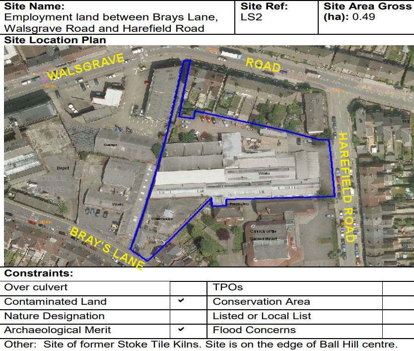
For this reason, Patricia and I felt that the photograph was reversed, and the next image is my screen-shot from a Google aerial view - we, the viewers, are "hovering" above the alleged Kiln site. The inset image shows the houses from the top-right corner of the photo, reversed, which we thought must be the Harefield Road houses, with the terraces leading downhill towards the Binley Road end.
However, on closer inspection of the houses, those in the old photo seem to be in groups of three, with one narrow window each - looking suspiciously like "backs" of houses, not fronts with a bay window downstairs. Additionally, the chimneys in the old photo have three square pots each, and the Google view shows four round pots on each stack, plus houses in groups of two, with two narrow windows flanked by two wider ones.
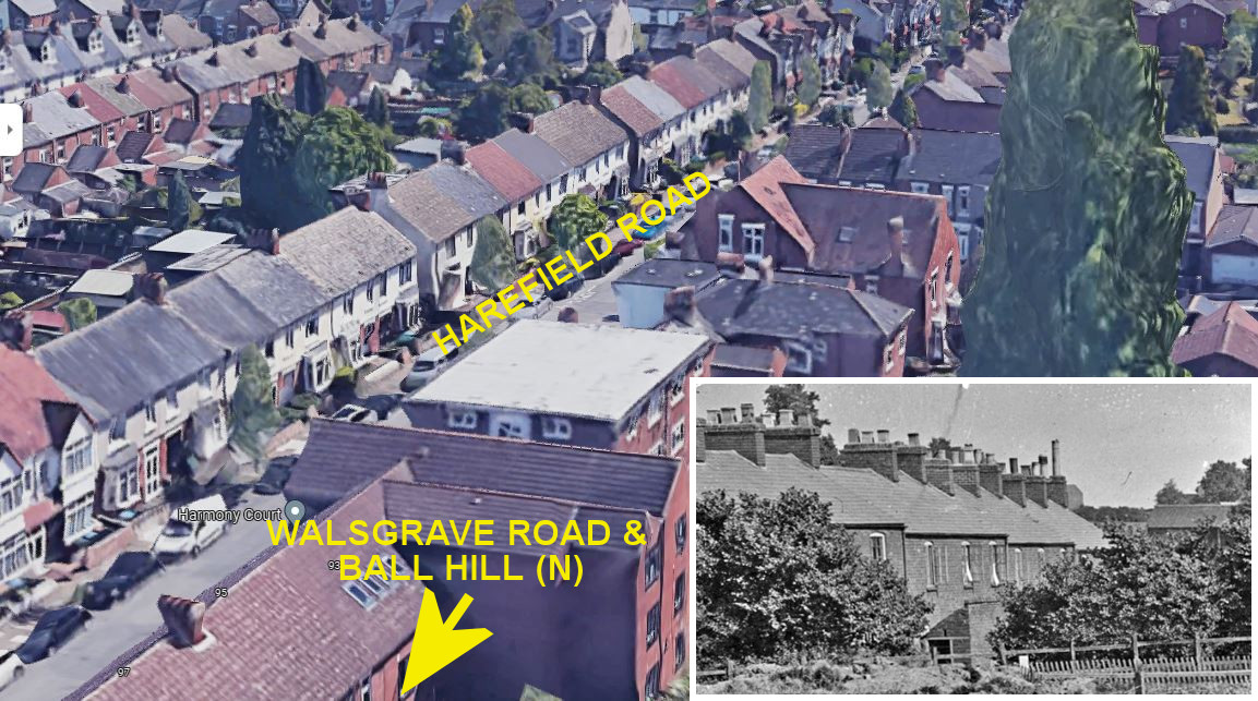
So, the question is.... if these ARE Stoke Kilns (which we'd really love them to be), are we looking in the wrong direction - or in the wrong place in Stoke? Or do we have to accept that the photo was taken elsewhere altogether? Ooh 'eck! |
|
Local History and Heritage -
Stoke Kilns
|
Helen F
Warrington
|
2 of 14
Sun 12th Nov 2023 12:40pm
Could the terrace be Field Row? That doesn't exist any more.
Another view of the kilns.
|
|
Local History and Heritage -
Stoke Kilns
|
Helen F
Warrington
|
3 of 14
Sun 12th Nov 2023 12:45pm
Better map. If the photo was reversed then the dig could have been on the other side of the Sowe Road, with the semi being the building on the left of the picture. Hopes Harbour etc in the far distance? Or it's the right way round and the road running left to right is Brays Lane? The more I think about it, the more I think that the photo is the right way round. You can even see one of the little outhouses in the photo. So It's looking northeast over Brays Lane? There's even an opening to the field that roughly matches where the entrance to the digging site is located,
|
|
Local History and Heritage -
Stoke Kilns
|
Helen F
Warrington
|
4 of 14
Sun 12th Nov 2023 3:26pm
From the Kenilworth Advertiser - Saturday June 24 1911
ANCIENT TILES AND KILN. |
|
Local History and Heritage -
Stoke Kilns
|
Rob Orland
Historic Coventry
Thread starter
|
5 of 14
Sun 12th Nov 2023 4:51pm
My word, Helen, you are a gem! So much to take in at the moment, but between what you've said, and shown in those maps, there's a lot more to consider - and makes it also more likely that we really are looking at the Stoke Kilns, and not somewhere else as we feared. 
This 1947 Historic England aerial view also reveals at least two or three good potential dig sites for the photo above. It could be that we're looking at a terrace of houses and chimneys in Field Row, as you've suggested, as there's is definitely a rough, undeveloped site near the bottom, Walsgrave Road, end ( the aerial photo is "upside-down", north at the bottom). Also rather quaint to see your map saying Sowe Road, not Walsgrave Road, as we're used to nowadays! This would probably mean, like you say, that the old photo isn't back-to-front after all.
There's also a definite "excavation looking" site to the left (east) of Brays Lane, just to the left of the butterfly shaped Stoke Park Estate - or "The Avenues", as we always called them as kids. This site is larger, and more similar to the old photo.... but doesn't give a likely view of terraced houses with ridge-top chimneys! Ooh 'eck again!
|
|
Local History and Heritage -
Stoke Kilns
|
Helen F
Warrington
|
6 of 14
Sun 12th Nov 2023 5:14pm
Since the excavation was 1911, there probably wasn't anything left to see in later years. My guestimate was that the kilns were round about the quadrant of Brays Lane, St Osburgh's Road and St Agatha's Road. The map below is 1913 and shows that the housing wasn't completed and might show where the house on the left of the photo was being built. There might be tile fragments in the gardens there? There might even be something to see in the small passageways running round the backs of the houses.
|
|
Local History and Heritage -
Stoke Kilns
|
Helen F
Warrington
|
7 of 14
Sun 12th Nov 2023 5:41pm
I also see that Hopes Harbour was Harefield. Also why the kiln was on the Harefield Estate but not necessarily Harefield Road. Link to Rob's smashing collection of pictures of Hopes Harbour |
|
Local History and Heritage -
Stoke Kilns
|
Rob Orland
Historic Coventry
Thread starter
|
8 of 14
Sun 12th Nov 2023 6:06pm
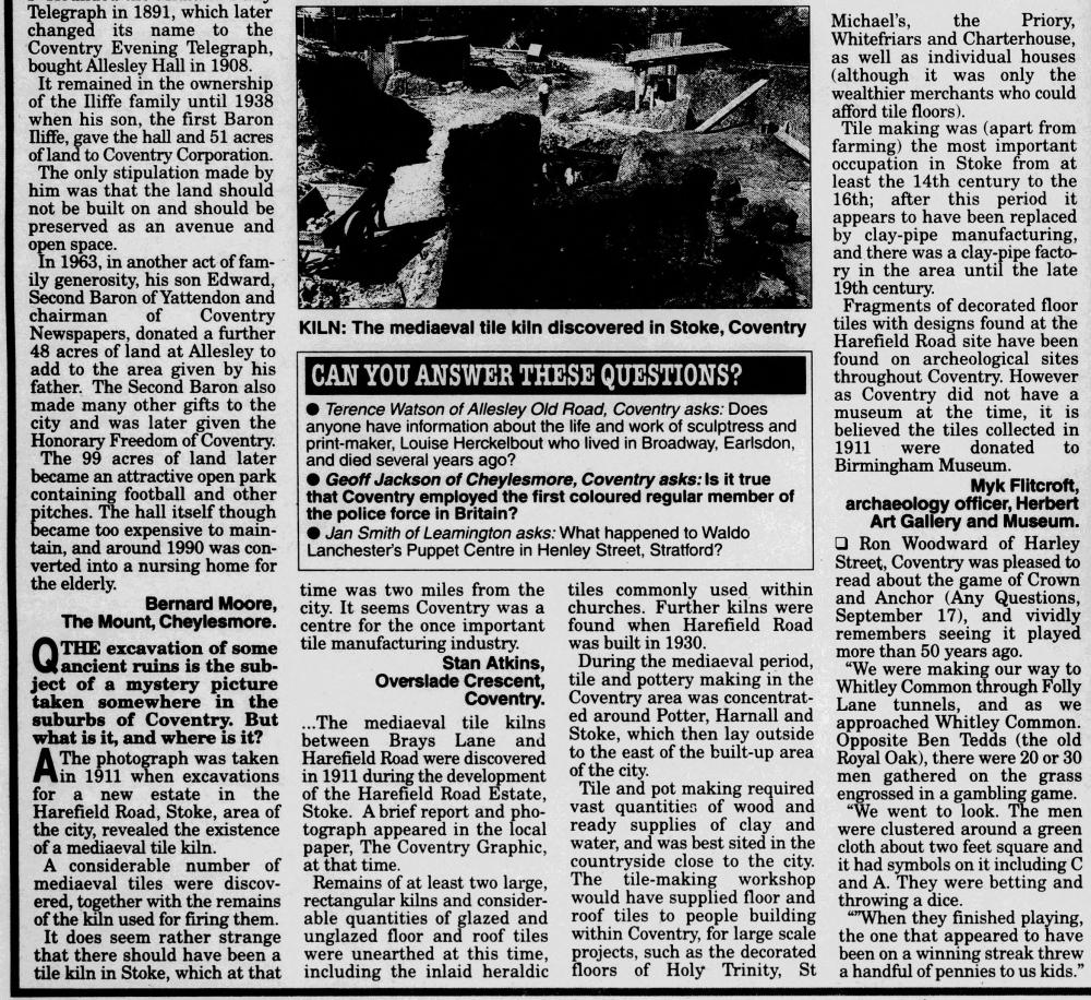
Thank you, Helen.  I've also found a newspaper article from 1997 discussing the photo in question, which turns out to be from 1911, and, if nothing else, it at least confirms that the photo from Coventry Digital IS the correct way around....
I made use of some of those Hope's Harbour images in this Stoke Article, too. |
|
Local History and Heritage -
Stoke Kilns
|
Rob Orland
Historic Coventry
Thread starter
|
9 of 14
Sun 12th Nov 2023 6:44pm
I think we're closing in on the location now, thanks to you, Helen, and Patricia's suggestion that the site is probably the more northerly of the two or more that were found. Patricia all along felt it might have been on the site of what became the British Transfer company, now known as B. T. P. Craftscreen.... except that originally we'd thought the photo was facing south-east towards terraced houses in Harefield Road.
So, I've cobbled together another Google aerial view, hovering over Walsgrave Road looking south-west towards Brays Lane. I've highlighted what are now industrial buildings on the line of the former Field Row. Now I'm beginning to see the angle that we could be looking at in that 1911 photo, if the Kilns were on or very close to the Printing company.....
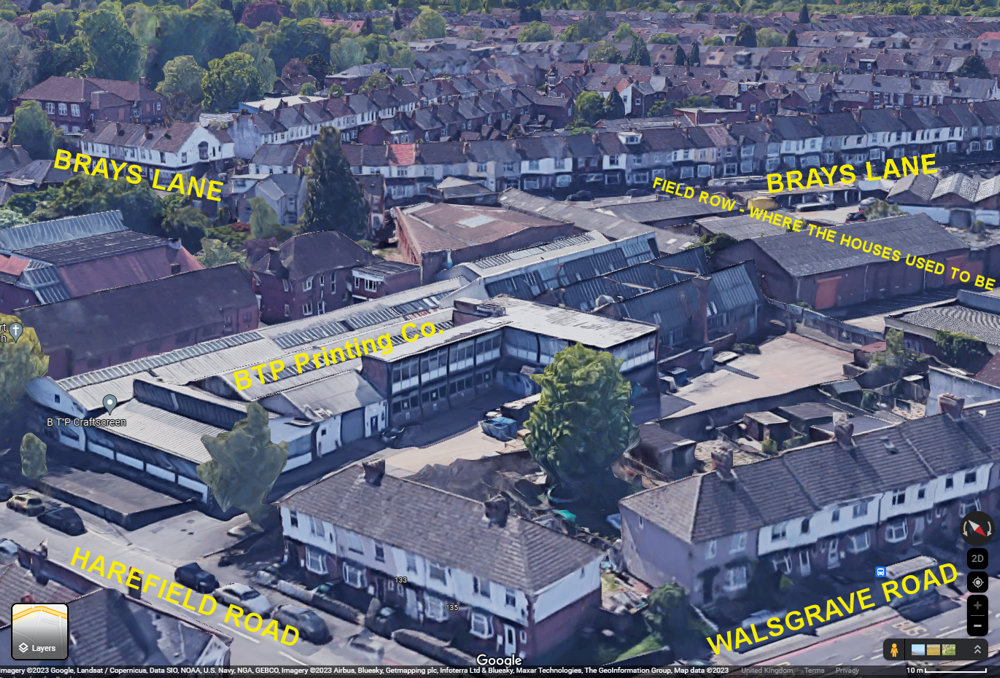
EDIT: I've slightly adjusted the location of Field Row after checking the Nat. Library of Scotland overlaid maps. The current alleyway, where I'd put the marker, is actually where the garden boundaries used to be - the houses were a tiny bit farther back. |
|
Local History and Heritage -
Stoke Kilns
|
Helen F
Warrington
|
10 of 14
Sun 12th Nov 2023 7:04pm
 There very probably were multiple kilns in the area. The article talks about finding tiles when the Harefield Road was built. The various pools in the area may well have been from extracting clay. But if the photo was 1911, on the 1913 map they hadn't started building that side of the estate. Not that we can totally rely on that because we've found some of them to be out of date before now. What drew me to the other direction is that there is a roadway or at the very least an old field boundary with both a fence and a hedge. It seems that apart from the Sowe/Walsgrave Road, the only obvious road or field boundary is Brays Lane. |
|
Local History and Heritage -
Stoke Kilns
|
Helen F
Warrington
|
11 of 14
Mon 13th Nov 2023 10:34am
It's not on at the moment but the BBC had a series called Secrets of the Castle. It was based in the new castle they're building in Gu |
|
Local History and Heritage -
Stoke Kilns
|
Choirboy
Bicester
|
12 of 14
Mon 13th Nov 2023 11:19am
Perhaps extraction from the sides of roads did serve a useful purpose of creating drainage ditches. "Clay Lane" is to the North of the where the kilns were found. Perhaps there is more to be found in that direction. |
|
Local History and Heritage -
Stoke Kilns
|
Rob Orland
Historic Coventry
Thread starter
|
13 of 14
Mon 20th Nov 2023 11:10am
On 12th Nov 2023 7:04pm, Helen F said:
 There very probably were multiple kilns in the area. . . .
There certainly does seem to be evidence to support there having been several kilns around Stoke - an area with pockets rich in clay. I'm guessing that this particular kiln in the 1911 photograph was probably the major one. Having discussed it with Patricia, and thanks also to Helen for the inspired pointer to Field Row for the houses in the background, I think we can now definitively place the photo, and its orientation, into this approximate location....
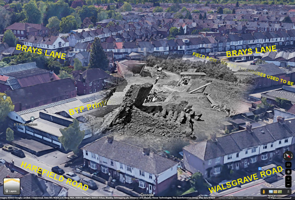 |
|
Local History and Heritage -
Stoke Kilns
|
|
oldndazed
|
14 of 14
Mon 20th Nov 2023 8:51pm
|
|
 For this reason, Patricia and I felt that the photograph was reversed, and the next image is my screen-shot from a Google aerial view - we, the viewers, are "hovering" above the alleged Kiln site. The inset image shows the houses from the top-right corner of the photo, reversed, which we thought must be the Harefield Road houses, with the terraces leading downhill towards the Binley Road end.
However, on closer inspection of the houses, those in the old photo seem to be in groups of three, with one narrow window each - looking suspiciously like "backs" of houses, not fronts with a bay window downstairs. Additionally, the chimneys in the old photo have three square pots each, and the Google view shows four round pots on each stack, plus houses in groups of two, with two narrow windows flanked by two wider ones.
 So, the question is.... if these ARE Stoke Kilns (which we'd really love them to be), are we looking in the wrong direction - or in the wrong place in Stoke? Or do we have to accept that the photo was taken elsewhere altogether? Ooh 'eck!


 I made use of some of those Hope's Harbour images in this
  EDIT: I've slightly adjusted the location of Field Row after checking the
