dutchman
Spon End
|
1 of 232
Sun 1st Jul 2012 2:04pm
On 1st Jul 2012 12:48pm, LesMac said (on another thread):
Am I right in thinking that further up Much Park St there was a brewery? A large slab fronted building on the right hand side. Somewhere where near where the Crown Court now stands. Or was that somewhere else and I am confused. Again.
Yes. It was built by Philips & Marriot but was eventually taken over by Bass/M&B. In later years it was used only as a regional office. |
|
Streets and Roads -
Much Park Street
|
LesMac
Coventry
|
2 of 232
Mon 2nd Jul 2012 9:11am
Thanks for reply. What a mine of information this forum is.
Les
|
|
Streets and Roads -
Much Park Street
|
Dreamtime
Perth Western Australia
|
3 of 232
Thu 13th Dec 2012 4:54pm
In case no one has looked in the guest book today - Sandra Dee is asking about St Michael's School on the London Road.
|
|
Streets and Roads -
Much Park Street
|
dutchman
Spon End
Thread starter
|
4 of 232
Thu 13th Dec 2012 8:49pm
I think she means the one in Much Park Street?
Old-Maps.co.uk
I'm sure it's been discussed here before when its location was mistaken for Gulson Road but cannot find it.
There was definitely a discussion in the Coventry Telegraph forum but this has now been deleted by Trinity-Mirror.  |
|
Streets and Roads -
Much Park Street
|
charabanc
Coventry
|
5 of 232
Fri 14th Dec 2012 2:30pm
I think that the St Michael's referred to is the one which was on Frankpledge Road, between there and the London Road next to Daventry Road.
It was a C of E primary school and was closed some years ago to be replaced by a small housing estate.
|
|
Streets and Roads -
Much Park Street
|
charabanc
Coventry
|
6 of 232
Fri 14th Dec 2012 2:46pm
Extracted from 'British History On Line', sponsored by Victoria County History re St Michael's -
Opened in association with Central N. (q.v.) and Greyfriars Lane (q.v.) schs.; 1853 housed in leased premises in Rose and Crown Yard (q.v.), Gosford St. (q.v.), and Greyfriars Lane; 1855 Rose and Crown Yard and Gosford St. closed and new sch. opened in Much Park St.; Greyfriars Lane (q.v.) continued as a branch sch.; 1948 became controlled sch.; 1958 Much Park St. closed and sch. rebuilt in Frankpledge Rd. (1, 10, 11, 12, 15, 16, 40). See also Red Lane N.
From: 'The City of Coventry: Public education', A History of the County of Warwick: Volume 8: The City of Coventry and Borough of Warwick (1969), pp. 299-315. URL: http://www.british-history.ac.uk/report.aspx?compid=16036 Date accessed: 14 December 2012.
|
|
Streets and Roads -
Much Park Street
|
NeilsYard
Coventry
|
7 of 232
Fri 14th Dec 2012 2:57pm
Which means it would have been right next to where the T&GW Union building is now by the Ring Road going by Dutchman's map |
|
Streets and Roads -
Much Park Street
|
dutchman
Spon End
Thread starter
|
8 of 232
Fri 14th Dec 2012 4:10pm
I have a vague memory of the building remaining standing between the newly-built Transport House and the Admiral Lord Rodney. Always assumed it was a church.
|
|
Streets and Roads -
Much Park Street
|
TEKMELF
HAWKESBURY
|
9 of 232
Sat 15th Dec 2012 11:07am
It was a school next to where the T&G building is now. My dad went there prior to moving to Cheylesmore School, Mile Lane. Between the Lord Rodney and the school there was a block of shops including the Dew Drop Inn cafe, Stokes's cycle shop and a sweet shop. The school was next set back from the road with a fence alongside the pavement, then there was the Salutation public house opposite Whitefriars St.
|
|
Streets and Roads -
Much Park Street
|
Foxcote
Warwick
|
10 of 232
Sat 15th Dec 2012 1:58pm
I found a photo of The Admiral Lord Rodney as it seems that the school was close by? There is a gap to the side and some building seems set back. I can't seem to find an image of the school anywhere though. |
|
Streets and Roads -
Much Park Street
|
dutchman
Spon End
Thread starter
|
11 of 232
Sat 15th Dec 2012 3:00pm
On 15th Dec 2012 11:07am, TEKMELF said:
It was a school next to where the T&G building is now.
I know that now, but at the time there was nothing to suggest it had once been a school 
|
|
Streets and Roads -
Much Park Street
|
Covjb35
Aberdare
|
12 of 232
Fri 18th Oct 2013 11:43am
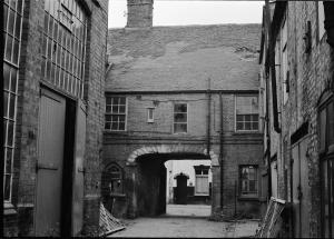
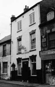
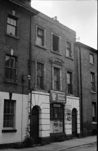
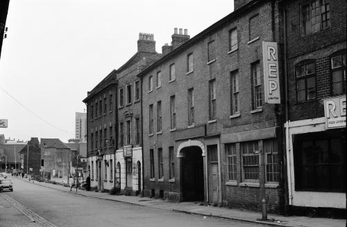
Hello, I'm a new member of this Forum and to start off I have submitted a photograph I took in the late 1960's-early 1970's. The image is of what I believe to be the workshop of Wm. Franklin & Son, ribbon and woven label makers. You can barely make out the name above the central arch. Further up the street is the Whitefriars Gate, on the left side.
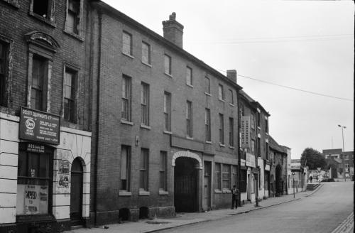
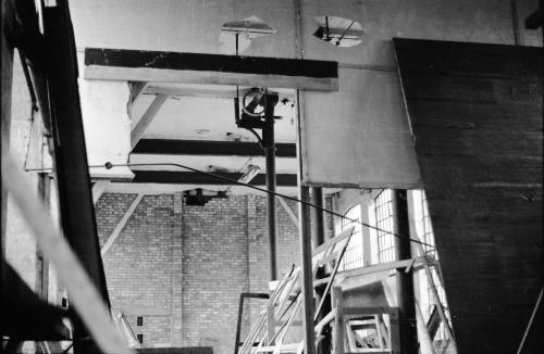
The second picture is a view from inside the arch looking towards the street.
 |
|
Streets and Roads -
Much Park Street
|
Wearethemods
Aberdeenshire
|
13 of 232
Fri 18th Oct 2013 11:49am
Welcome to the forum covjb, and thanks for introducing the new topic. Do you have any more snapshots?
|
|
Streets and Roads -
Much Park Street
|
NormK
bulkington
|
14 of 232
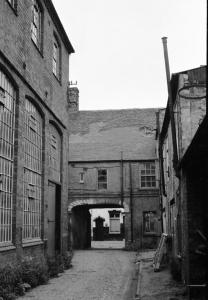
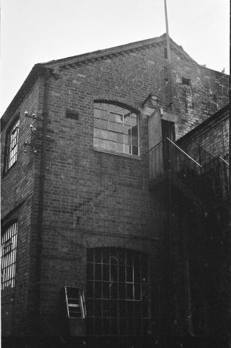
Fri 18th Oct 2013 12:05pm
covjb. That's odd, see how tall the building is from the street, yet at the rear it's quite small. What do you think?  Loft conversion?  |
|
Streets and Roads -
Much Park Street
|
Covjb35
Aberdare
|
15 of 232
Fri 18th Oct 2013 12:43pm
|
|
Streets and Roads -
Much Park Street
|

