Prof
Gloucester
|
61 of 151
Thu 8th Mar 2018 7:00pm
On 28th Jan 2013 7:25am, Rob Orland said:
On 27th Jan 2013 9:02pm, Foxcote said:
I should like to know more about the Weighing Machine, Stoke, it was demolished in the 1950's. It looked really old. Does anyone remember it?
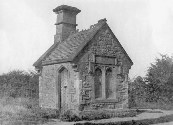
Although it was before my time, it does mention Dane Road, and I reckon it could possibly have been in the corner of St. Margaret's Field, which you can see in this Google Maps link, where we often used to play as kids.
The weighing machine was, as Rob stated, in the field at the junction of Dane Road with Walsgrave Road, and Ansty Road, the farther side of the field on Ansty Road being Wyken Croft Road I think. |
|
Coventry Suburbs and Beyond -
Stoke
|
Prof
Gloucester
|
62 of 151
Thu 8th Mar 2018 7:28pm
Looking at your group of Stoke photos, Rob, I am immediately transported back home, as I know all these streets like the back of my hand and lived in Momus Boulevard from the age of ten. I noted in a recent quiz programme on TV that Momus was the god of mockery. So named perhaps because when built it was merely half of what one would expect a boulevard to be! |
|
Coventry Suburbs and Beyond -
Stoke
|
Annewiggy
Tamworth
|
63 of 151
Mon 23rd Apr 2018 4:18pm
Just looking through a 1689 will of one of my ancestors Samuel Harwar. He mentions a close of land called Lamplands which he asks them to sell to pay of his debt to Edward Day, to put towards his financial expenses and to pay off any other debts. Cash flow must have been bad! Has anyone come across the name Lamplands, I can't find it on a map.
|
|
Coventry Suburbs and Beyond -
Stoke
|
jonboy
styvechale coventry
|
64 of 151
Tue 24th Apr 2018 2:11pm
On 8th Mar 2018 7:00pm, Prof said:
The weighing machine was, as Rob stated, in the field at the junction of Dane Road with Walsgrave Road, and Ansty Road, the farther side of the field on Ansty Road being Wyken Croft Road I think.
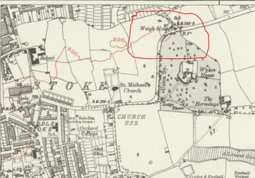
If I remember rightly the weighbridge was situated in the area of what became the builders yard belonging to Youells opposite the Walsgrave pub. |
|
Coventry Suburbs and Beyond -
Stoke
|
Annewiggy
Tamworth
|
65 of 151
Tue 24th Apr 2018 3:20pm
That looks as if it is where it was jonboy. This is a 1928 map, no Dane Road but the position is where you describe it.
|
|
Coventry Suburbs and Beyond -
Stoke
|
Prof
Gloucester
|
66 of 151
Sun 7th Oct 2018 8:06pm
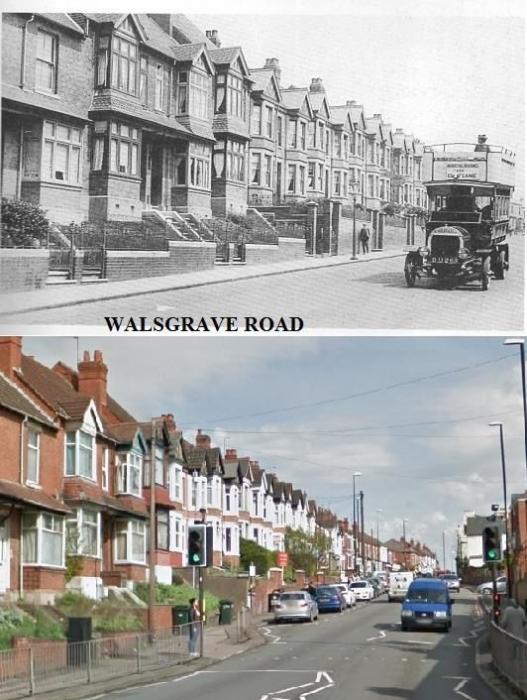
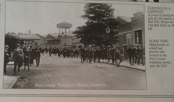
The Gosford Green end approaching Ball Hill
 |
|
Coventry Suburbs and Beyond -
Stoke
|
Dreamtime
Perth Western Australia
|
67 of 151
Mon 8th Oct 2018 12:32pm
Good ones Prof. I have to admit I would feel a right nerd sitting up there on my own.  |
|
Coventry Suburbs and Beyond -
Stoke
|
Prof
Gloucester
|
68 of 151
Thu 8th Nov 2018 11:13am
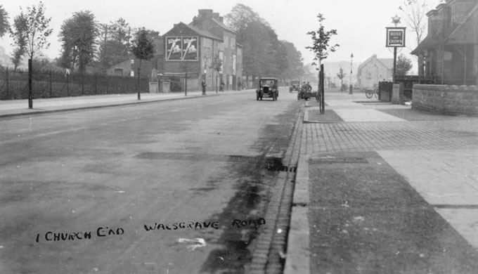
Note the top shops on Walsgrave Rd, on the edge of Stoke Churchyard. I remember them there! Also an early photo as there is no lych-gate, erected in late 1920s. |
|
Coventry Suburbs and Beyond -
Stoke
|
Kaga simpson
Peacehaven, East Sussex
|
69 of 151
Fri 9th Nov 2018 5:35pm
Prof,
Your second picture - was that the library on the right by the blue van?
And note all the trees in the third picture, wasn't that somewhere near the cemetery? Remember about that time coming home from the Forum on a dark windy night and finding we were in the graveyard - real scary. Note also the motor bike and sidecar, all the rage in the thirties.
Yes, 1948 summer time, and many a night I walked along that road from town to the other side of Ansty, little traffic and no lift. What I did for women! But then I had just spent two years without seeing an English girl, or any girl for that matter - at eighteen, a lost youth, shades of war and after. 'Don't cry for me Angelina'. |
|
Coventry Suburbs and Beyond -
Stoke
|
Prof
Gloucester
|
70 of 151
Fri 9th Nov 2018 6:01pm
Hello Kaga, glad you are better.
The Stoke Library on the corner of Kingsway and Walsgrave Road is just to the right but out of the picture, before the pedestrian lights; the red brick affair I think is the gateway to St Margaret's Church. I joined the Stoke Junior Library when I was nine years old, with another boy from my class, who borrowed non-fiction books on isobars, cloud formation and other weather-related topics. I often wonder whether he became a Professor?
The b&w photo does show Stoke St Michael's graveyard, where my family are buried, both parents dying young: mother 40 and father 58. No doubt you remember the top shops by the churchyard too? My dad had a motorbike and sidecar in the early thirties but later upgraded to a car, a Lanchester with double declutch mechanism. He worked for Humber all his life, mostly at Rootes shadow factory (Toll Bar End). |
|
Coventry Suburbs and Beyond -
Stoke
|
Kaga simpson
Peacehaven, East Sussex
|
71 of 151
Sun 11th Nov 2018 10:27am
Annewiggy.
Although I can see the map says weigh house, could it not have been an old mortuary chapel of the 18th-19th century that stood in the bottom of St Michael's cemetery, then converted. It was the custom in Victorian funerals for the body to be set down to rest in a chapel in the graveyard, with the mourners standing round in silence, before the final burial - its ancient form giving it continuity across the centuries, the newly dead emerging with the scattered bones of ancient local people.
Standing near the road but just inside the old cemetery, it's about the right size as a single door, an oak or wooden arched door and narrow curved arch windows - fits the bill completely.
I have walked through that old cemetery field to reach Bell Green when a kid a number of times. |
|
Coventry Suburbs and Beyond -
Stoke
|
Prof
Gloucester
|
72 of 151
Sat 29th Dec 2018 7:21pm
cf with Rob's post 12 |
|
Coventry Suburbs and Beyond -
Stoke
|
Kaga simpson
Peacehaven, East Sussex
|
73 of 151
Sat 16th Mar 2019 3:08pm
MisterD-Di, hi.
There is a photo somewhere on this forum that shows a weighbridge on the Ansty Road. I wondered if you ever visited it, or knew anything about it? It is nothing like any other weighbridge I ever saw in or around Coventry, or what it weighed, and no one in Stoke History seems to know either. Would love to know your thoughts and expertise about this building.
Regards, Kaga.
|
|
Coventry Suburbs and Beyond -
Stoke
|
Midland Red
|
74 of 151
Sat 16th Mar 2019 6:06pm
This one, Kaga? "Demolished in the 1950's".
On 8th Mar 2018 7:00pm, Prof said:
On 28th Jan 2013 7:25am, Rob Orland said:
On 27th Jan 2013 9:02pm, Foxcote said:
I should like to know more about the Weighing Machine, Stoke, it was demolished in the 1950's. It looked really old. Does anyone remember it?

Although it was before my time, it does mention Dane Road, and I reckon it could possibly have been in the corner of St. Margaret's Field, which you can see in this Google Maps link, where we often used to play as kids.
The weighing machine was, as Rob stated, in the field at the junction of Dane Road with Walsgrave Road, and Ansty Road, the farther side of the field on Ansty Road being Wyken Croft Road I think.
|
|
Coventry Suburbs and Beyond -
Stoke
|
Annewiggy
Tamworth
|
75 of 151
Sat 16th Mar 2019 6:14pm
For many years a gentleman called Alfred Clements was Parish Clerk and he is on many censuses as living in Orchard Cottage and he is the rate collector. In a 1916 newspaper it says that he he has given in his notice as he is ill. His address is then given as Weigh House, Walsgrave Road. He died in 1919 and his probate again gives his address as Weigh House. His wife died in 1931 and she was still living there. Surely they could not have been living in that building, although it does have a chimney? |
|
Coventry Suburbs and Beyond -
Stoke
|



![First page [or press the "F" key] First page](../resource/colour_tint_inc.php?img_file=left-arrow-end.png&clr=AA5511)
![Previous page [or press the "Left arrow" key] Previous page](../resource/colour_tint_inc.php?img_file=left-arrow.png&clr=AA5511)
![Next page [or press the "Right arrow" key] Next page](../resource/colour_tint_inc.php?img_file=right-arrow.png&clr=AA5511)
![Last page [or press the "L" key] Last page](../resource/colour_tint_inc.php?img_file=right-arrow-end.png&clr=AA5511)


 Note the top shops on Walsgrave Rd, on the edge of Stoke Churchyard. I remember them there! Also an early photo as there is no lych-gate, erected in late 1920s.
 cf with Rob's post 12