Helen F
Warrington
|
1 of 21
Thu 30th Dec 2021 1:24pm
The idea behind this topic is to examine the influences on why Coventry is where it is and why it was structured the way it was. There's no plan on how this should progress but I thought I'd start with some height maps. I've marked on what I think are the major roads but I'm very open to persuasion that some of the routes are modern or that I've missed an important road.
Height Map link
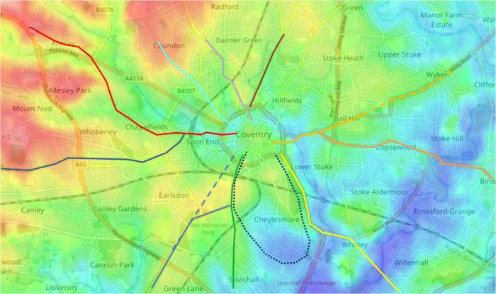
Starting at the top -
Brown - Foleshill, Bedworth, Nuneaton
Light Orange - Far Gosford, Wyken, Ansty, Leicester
Dark Orange - Binley, Rugby
Yellow - Whitley, London
Black dotted - the deer park
Green - Stivichall, Stoneleigh, Warwick
Blue - Kenilworth, Warwick, Stratford
Blue dotted - possible alternate route into the city round
Dark Blue - Tile Hill
Red - Spon End, Allesley, Holyhead/Chester
Pale Blue - Coundon
Pale Purple - Atherstone, Tamworth
|
|
Local History and Heritage -
Topography, Geography and Landscape
|
belushi
coventry
|
2 of 21
Thu 30th Dec 2021 1:35pm
Excellent resource Helen. Scrolling out it shows how low Coventry is compared to Birmingham and the Black Country. Easy to see why West Brom's ground is the highest League ground in England.
Also the watershed separating the Severn and Trent drainage basins to Coventry's west is clearly shown.
|
|
Local History and Heritage -
Topography, Geography and Landscape
|
PhiliPamInCoventry
Holbrooks
|
3 of 21
Thu 30th Dec 2021 1:48pm
Hi,
Something else that the topography map shows is relevant to our weather topic. The so called Coventry shield, where because our prevailing weather is a south to northwesterly source, Coventry benefits from a slight Evesham effect, where air coming from those directions loses height, losing some of the rising air current energy in the process. It's rising air scenarios that cause rainfall.
|
|
Local History and Heritage -
Topography, Geography and Landscape
|
Helen F
Warrington
Thread starter
|
4 of 21
Thu 30th Dec 2021 3:40pm
Outlined in blue I've shown the moister areas of the city (the blue doesn't represent water, just lower lying areas). Coventry is almost surrounded on 3 sides by river and former marshy land. The Burges are the logical place to cross from the north but the road coming from Allesley crosses the Sherbourne twice. Once at Spon End and again at Smithford Street. A more logical dry route would be to skirt the river and remain on the south side before entering via the Greyfriars Lane. Or stay north of the river and enter the city from the north. The only explanation I can think of was that it was just a quicker and flatter route from an equally old settlement at Spon End.

There is a natural pinch point at the Burges. You could imagine that before the area was carved and embanked that water could have backed up towards Bablake forming a lake. The yellow lines are main river crossing routes and the red ones lesser ones.
|
|
Local History and Heritage -
Topography, Geography and Landscape
|
Primrose
USA
|
5 of 21
Thu 30th Dec 2021 10:09pm
I've not paid much attention in the past to Coventry's waterways even though my mum was born in Sherbourne Street and remembers the house getting flooded. I had a look at the height map link in Helen's post and see red dotted lines that appear to represent streams, etc. I see one running behind King Edward Road in Hillfields - we called it "the brook" when I was a child and a source of great fascination it was. I wasn't allowed to play anywhere near it, of course. It was shallow and a bit smelly. I supposed it ran under Berry Street and along or near Brook Street. The height map shows that to be the case.
I've been oblivious to all of the water sources in Coventry in spite of enormous clues like the Swanswell itself (I passed it whenever I went into town), Bablake and Pool Meadow. Looking forward to seeing where this thread goes!
|
|
Local History and Heritage -
Topography, Geography and Landscape
|
Helen F
Warrington
Thread starter
|
6 of 21
Fri 24th Jun 2022 10:54am
Usual warning - this is all highly speculative and just throwing out ideas. Due to the length, I'm breaking it down to more digestible chunks.
Part 1
To return to the question of why Coventry is where it is, I thought I'd go back to prehistoric times. As things warmed up and ice retreated, the land would have gone from bare rock or silt, to alpines, to grass, to small shrubs and then trees. The distribution of tree species varied as temperatures and rainfall went up and down but even from the first incursion of humans there were better lands than others to colonise.
A complicated description of British forest progress can be found here
And something more user friendly here.
The later species were slower to move north and to become abundant, as there was no vacant ground to colonise. Beech and lime did not spread beyond southern Britain. From the time lime trees arrived, in about 7300, to about 4500 BC there was a period of relative climatic stability called the Atlantic Period, during which the various species settled to form a series of wildwood or wilderness types, as shown in the diagram. The tree line was much higher than now, as shown by the remains of trees found in present-day moorland. The tree line varied across the country.
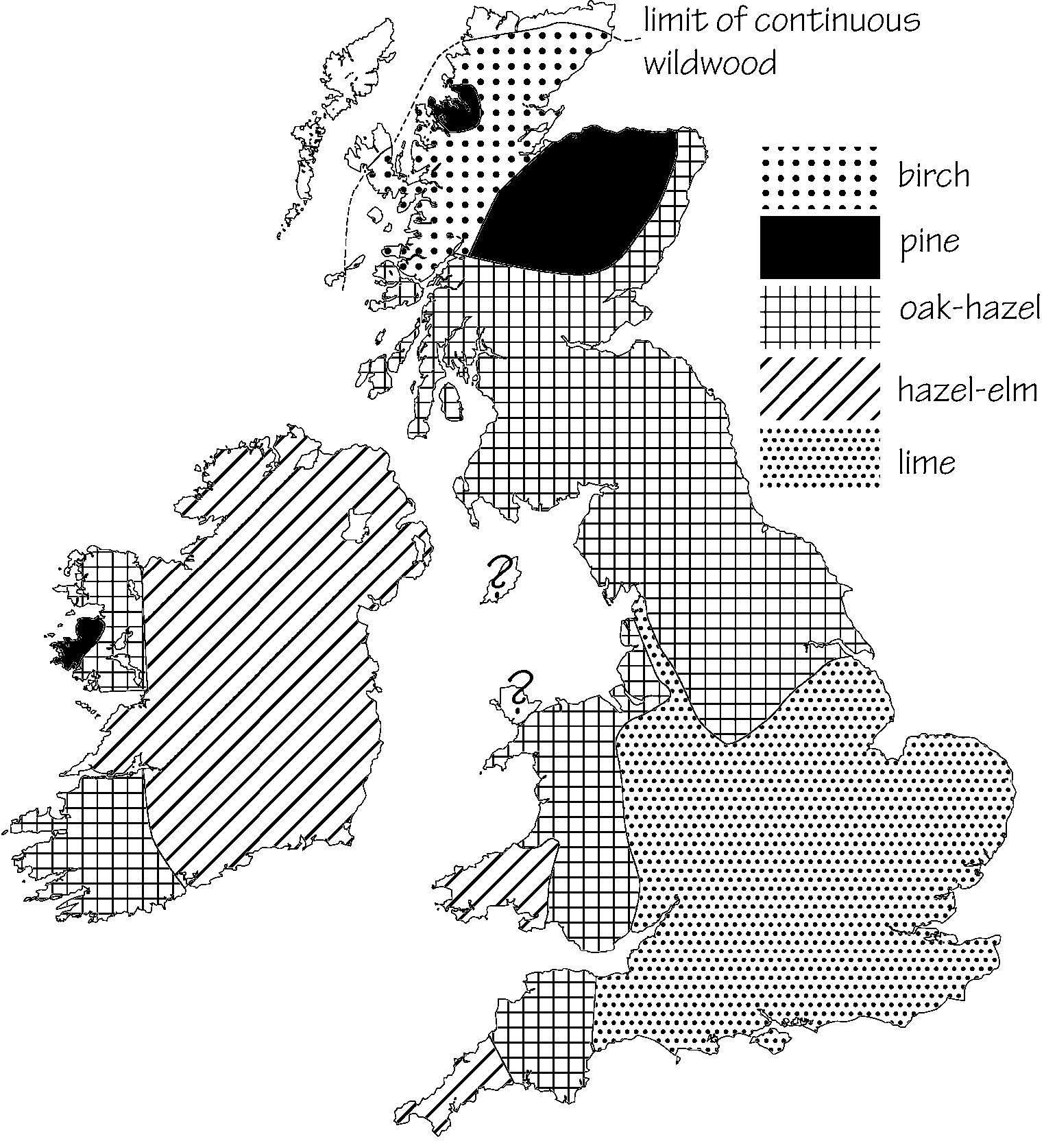
A rough map which is missing the Forest of Arden bubble but gives you the basic idea of the predominant species.
This reference talks about a global climactic era called the Holocene Optimum which was significantly warmer than present. It was followed by a series of warm and cold spells that saw civilisation expand and contract with the temperatures including the Minoan/Egyptian Warm Period, the Roman Warm Period and the Medieval Warm Period. Modern temperatures are somewhere comparable to the last two warm periods but we've just come out of one of the coldest parts of the last 10,000 years. Those Dickensian winters were the exception, not the rule. Until the Industrial Revolution human success was tied quite well with warmth.
|
|
Local History and Heritage -
Topography, Geography and Landscape
|
PhiliPamInCoventry
Holbrooks
|
7 of 21
Fri 24th Jun 2022 12:04pm
Otherwise known as-:
Geomorphology
Greenland is a treasure trove of climate facts. The Danes called it Greenland, for its abundant sheep pastures up until the fifteenth century. The archaeology of sheep bones shows very healthy & well nourished flocks, until the succession of very cold periods, that devastated the northern hemisphere, turned Greenland into Whiteland. This all within the last five hundred years.
A quote from Wiki,
"In Greenland, this breed is almost exclusively bred for meat. Lambs are not fed grain or given hormones. The meat has a fine grain and distinct, delicate flavor. The meat of the Greenlandic sheep is quite special and considered by many experts to be among the best in the world and considered a gourmet style of meat. The taste and quality are closely linked to the animals' life conditions."
|
|
Local History and Heritage -
Topography, Geography and Landscape
|
Helen F
Warrington
Thread starter
|
8 of 21
Fri 24th Jun 2022 5:00pm
Hi Philip. I think Greenland was still pretty icy during the Viking era. The main ice core is very deep, such that it depressed the earth and has, along with mountain ranges, created a bowl in which the bulk of the ice sits. The first recorded instance of estate agent speak?  However items from the Viking times are beginning to emerge from the glaciers. There were trees in places where, not only can they still not grow, but those trees were spread and established over many mild years, not just a few good ones. When the cold resumed only the natives survived because they relied on things they could catch from the sea, like seal meat and blubber.
The lamb sounds delicious. Those who try to recreate medieval historical eras struggle to find suitable animals, as modern breeds, even heritage ones tend to be bigger in all dimensions. The Cattle of the Middle Ages look like they were between half and two thirds the size of modern breeds. You can't handle modern sheep like these shearers are doing.

|
|
Local History and Heritage -
Topography, Geography and Landscape
|
PhiliPamInCoventry
Holbrooks
|
9 of 21
Fri 24th Jun 2022 5:45pm
Oh I love this Helen,
Icy I'm sure, not just because of its proximity to the Arctic, but also its altitude & being such a huge land mass.
Climate is a big potato for me. I'm sticking my neck out here, but I honestly believe that our Sun's output variation has got as much to do with climate change as anything else. I understand the science behind the effect of greenhouse gases global heat retention in our atmosphere, but I listen to facts too. The amount of heat retention substance that's constantly ejected from our world's volcanoes is staggering, more than China's exhaust. Also, no one has satisfactorily explained why the planet Mars is also warming in very similar temperature patterns to ours here on Earth. Twenty years ago, the Astronomy mag headline asked if gas guzzling Martians, were driving around in their four by fours. Well, whatever next!
PS. A very recent news item:
"Now scientists are telling us that Mars is experiencing its own planetary warming: Martian warming. It seems scientists have noticed recently that quite a few planets in our solar system seem to be heating up a bit, including Pluto. NASA says the Martian South Pole's "ice cap" has been shrinking for three summers in a row"
Gosh, they're all at it!
|
|
Local History and Heritage -
Topography, Geography and Landscape
|
Helen F
Warrington
Thread starter
|
10 of 21
Fri 24th Jun 2022 6:21pm
Part 2
It was generally thought that the Romans were the first to decimate England's forests but increasingly it looks like the country's patchwork of fields, small stands of trees and larger forests were already establishing before the Roman's arrived. Less than 50% of the original wildwood remained by the iron age and most of that was in the Scottish Highlands, northern England, and Wales. The bronze-agers were very busy with their axes.
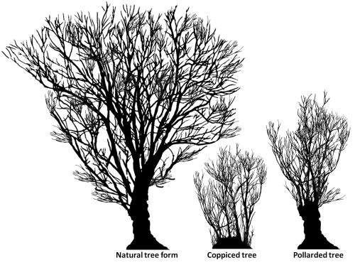
From early times there would have been managed forests, where trees were controlled by humankind to serve them better. There is evidence of coppicing in England as far back as 4500BC. Most of you will know that coppicing is the art of regularly cutting trees back to the base so that new shoots spring up and grow into even, long branches. Perfect for many uses, from firewood to fencing to basket weaving. Coppicing trees almost makes them immortal as they are rejuvenated by the process. They are also quick to grow as the branches are supported by an already large root system. Trees were also pollarded to achieve similar results but to keep the tasty shoots beyond the reach of nibbling animals like deer. The leaves and supple twigs stripped from the harvested branches were used as animal feed, both immediately and for winter supplies. Unlike fallen autumn leaves they would be packed with energy, locked in at the time of cutting. Other trees would be chosen for special purposes and preserved for many decades so that they could be used for cruck frames or major beams. All inhabited places would have needed some kind of woodland for survival.
|
|
Local History and Heritage -
Topography, Geography and Landscape
|
|
Robthu
|
11 of 21
Fri 24th Jun 2022 6:26pm
|
|
|
Helen F
Thread starter
|
12 of 21
Fri 24th Jun 2022 7:12pm
|
|
|
PhiliPamInCoventry
|
13 of 21
Fri 24th Jun 2022 8:03pm
|
|
|
Helen F
Thread starter
|
14 of 21
Fri 24th Jun 2022 8:19pm
|
|
Robthu
Coventry
|
15 of 21
Sat 25th Jun 2022 7:39am
On 24th Jun 2022 6:21pm, Helen F said:
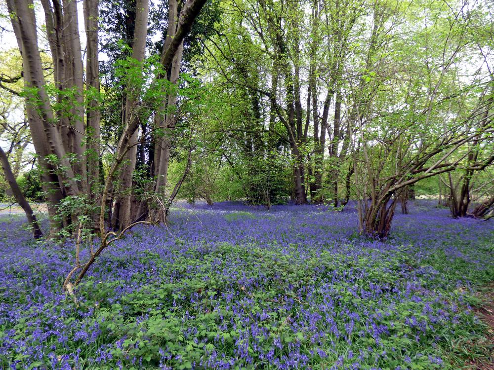
From early times there would have been managed forests, where trees were controlled by humankind to serve them better. There is evidence of coppicing in England as far back as 4500BC. Most of you will know that coppicing is the art of regularly cutting trees back to the base so that new shoots spring up and grow into even, long branches. Perfect for many uses, from firewood to fencing to basket weaving. Coppicing trees almost makes them immortal as they are rejuvenated by the process. They are also quick to grow as the branches are supported by an already large root system.
This picture shows you what coppiced woodland looks like, in the picture are Small-leaved Lime, (Linden, "Ger") Tillia cordata and Hazel, Corylus avellana, both these are native to this country and have always been here. They are both food plants and tool plants, the Lime was fodder (yes you can eat the leaves) the wood although a hardwood is relatively soft and cut/carved easily, it is also food-safe for eating off. the Hazel you will all be familiar with, nuts, sticks and wattle and daub housing etc. These are what are known as lapsed coppice and to try and bring them back into production after this length of time would probably kill them. the photograph was taken in Piles Coppice a remnant of the ancient Forest of Arden and is situated on the side of the Eastern By-pass, Coventry.
 |
|
Local History and Heritage -
Topography, Geography and Landscape
|


