|
rolffan
Horwich |
1 of 15
Sat 19th Feb 2011 9:01am
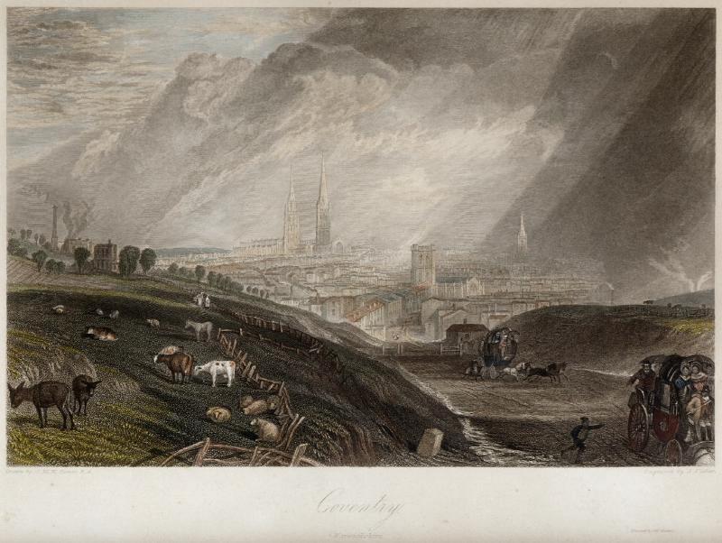
Recently realised that Turner did an engraving of Coventry in about 1830 - link.
It seems to be taken at the approach to the city, about 1/2 mile from the cathedral, going down a dip. Anyone recognise where the viewpoint is? It would be nice to have green fields like this with donkeys and sheep now!
|
| Local History and Heritage - JMW Turner engraving of Coventry | |
|
Rob Orland
Historic Coventry |
2 of 15
Sat 19th Feb 2011 11:15am
Hi rolffan,
He did indeed, and it's a really nice picture, too. I have an original copy on our wall - 50 quid from eBay a few years ago! (scan of it below). It's a beautifully atmospheric image, although the copy is not very large - only about 9 inches across - not much bigger than the scan.
Anyway, the view is from Holyhead Road, which is where these wagons are struggling up. When Turner did this picture the road was newly built (late 1820s) by Thomas Telford. Obviously this was before the railway cut across it, so you can see clear down to where the road turns gently right to intersect Spon Street and Fleet Street, just the right of St. John's Church in the picture. It certainly does make you yearn for this sort of view nowadays, doesn't it!
 |
| Local History and Heritage - JMW Turner engraving of Coventry | |
|
dutchman
Spon End |
3 of 15
Sat 19th Feb 2011 12:17pm
Not quite Rob. The railway was built some distance behind the painter, it's the Ring Road which cuts across the view today. The steps on the extreme right are the entrance to a footpath which later became Minster Road after the embankment was levelled off. The buildings between St. John's Church and the junction with Holyhead Road are all in Spon Street rather than Fleet Street.
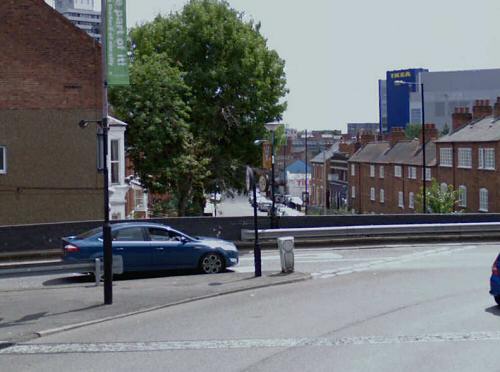
The strange thing is, walking along that same stretch of road today, you would swear that the Mercia House tower block was at the end of it when in fact it's in a completely different street altogether!
|
| Local History and Heritage - JMW Turner engraving of Coventry | |
|
Rob Orland
Historic Coventry |
4 of 15
Sat 19th Feb 2011 5:21pm
Ah, you're quite right of course, thank you. I was imagining myself standing farther back along the Holyhead Road, it's quite deceptive. The Google-Maps view I've put below from the Ring Road looks like it could be close to the place from where Turner depicted the scene. Some maps also don't agree about Fleet St / Spon St either! My 1932 map shows Fleet St going up to Holyhead Road, but others show Spon St all the way to St. John's. I think you're right though, because originally the city wall next to the church would've been where Spon St began.
 |
| Local History and Heritage - JMW Turner engraving of Coventry | |
|
dutchman
Spon End |
5 of 15
Sat 19th Feb 2011 6:16pm
This is the original watercolour sketch from which the engraving was made:
 The high-point of the mound on the left corresponds to where the Days Hotel (formerly Aston Court) is located today at the junction of Barras Lane and Holyhead Road. The Ring Road is the next junction beyond it.
 |
| Local History and Heritage - JMW Turner engraving of Coventry | |
|
Rob Orland
Historic Coventry |
6 of 15
Mon 21st Feb 2011 10:39pm
As always dutchman, I'm so impressed by your knowledge! Where did you find that original image? And how were you so accurately able to correspond the position on the picture to the modern-day streets? I must say though, that's one of many old pictures that I'd love to be able to afford to hang on our wall! I guess I'll have to make do with the engraved copy for now.
|
| Local History and Heritage - JMW Turner engraving of Coventry | |
|
dutchman
Spon End |
7 of 15
Tue 22nd Feb 2011 12:02am
Rob Orland said:
Where did you find that original image?
There used to be a website called "Spon-Line" which featured pictures and articles about the history of Spon End. The whole site disappeared some time ago without explanation but not before I managed to archive some of the more interesting pictures.
Rob Orland said:
And how were you so accurately able to correspond the position on the picture to the modern-day streets?
Partly from the description of the picture on the now defunct website and partly from walking that particular stretch of road on a regular basis. The mound on the left is still there but heavily built-upon these days.
|
| Local History and Heritage - JMW Turner engraving of Coventry | |
|
anne
coventry |
8 of 15
Sat 31st Mar 2012 9:45pm
On 19th Feb 2011 6:16pm, dutchman said:
The high-point of the mound on the left corresponds to where the Days Hotel (formerly Aston Court) is located today at the junction of Barras Lane and Holyhead Road. The Ring Road is the next junction beyond it.
Yes - I have been working this out without knowledge of this thread and came to the same conclusion - thanks for the link, Rob! Dutchman, do you know of any historical mention of the tollgate, please? |
| Local History and Heritage - JMW Turner engraving of Coventry | |
|
dutchman
Spon End |
9 of 15
Sat 31st Mar 2012 10:07pm
On 31st Mar 2012 9:45pm, anne said:
Dutchman, do you know of any historical mention of the tollgate, please?
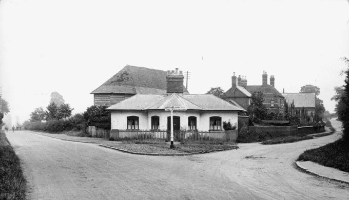
 Caption from a similar picture in "The Coventry We Have Lost" Vol 1:
This Toll House which stood at the junction of the Holyhead and Allesley Old Road originally had gates across both roads. A toll was charged to users of the Holyhead or Turnpike Road to defray the cost of building the Thomas Telford Road between 1828 and 1831.This charge was discontinued around 1930 and the Toll House was demolished during road widening in the mid 1930s, the only reminder of its existence being the 'Toll Gate Inn'.
 |
| Local History and Heritage - JMW Turner engraving of Coventry | |
|
PhiliPamInCoventry
Holbrooks |
10 of 15
Sat 31st Mar 2012 10:12pm
Hi & thank you Dutchman
|
| Local History and Heritage - JMW Turner engraving of Coventry | |
|
PhiliPamInCoventry
Holbrooks |
11 of 15
Sat 31st Mar 2012 10:32pm
Hi all
|
| Local History and Heritage - JMW Turner engraving of Coventry | |
|
anne
coventry |
12 of 15
Sun 1st Apr 2012 10:53am
That's a fantastic picture - thank you! I was thinking about the tollgate that seems to be in Turner's picture, esp. the engraving. Maybe it isn't a tollgate but something else?
|
| Local History and Heritage - JMW Turner engraving of Coventry | |
|
anne
coventry |
13 of 15
Sun 1st Apr 2012 11:22am
On 19th Feb 2011 11:15am, Rob Orland said:
. . . the view is from Holyhead Road, which is where these wagons are struggling up. When Turner did this picture the road was newly built (late 1820s) by Thomas Telford. Obviously this was before the railway cut across it, so you can see clear down to where the road turns gently right to intersect Spon Street and Fleet Street, just the right of St. John's church in the picture. It certainly does make you yearn for this sort of view nowadays, doesn't it!
Yes, it certainly does, Rob! |
| Local History and Heritage - JMW Turner engraving of Coventry | |
|
dutchman
Spon End |
14 of 15
Sun 1st Apr 2012 10:11pm
On 1st Apr 2012 10:53am, anne said:
That's a fantastic picture - thankyou! I was thinking about the tollgate that seems to be in Turner's picture - esp. the engraving. Maybe it isn't a tollgate but something else?
I can't find any reference to it Anne. I think what may look like a tollgate are the cattle bars from which Barras or Barr's Lane may get its name? Looking at old maps there was already a road which predated Thomas Telford's on this side of the lane as you look at it in the engraving.
*The exact location of the cattle bars and origin of the name Barr's Lane is the subject of much speculation. |
| Local History and Heritage - JMW Turner engraving of Coventry | |
|
anne
coventry |
15 of 15
Mon 2nd Apr 2012 8:26pm
Thank you for that! I look at the road there every day when I go to work and visualise the scene in the painting
|
| Local History and Heritage - JMW Turner engraving of Coventry | |
Website & counter by Rob Orland © 2026