
|
Maya
York |
1 of 35
Wed 4th Sep 2019 9:11pm
My sister was born at the The Hollies in 1947. My baby book states that I was born at The Sunnyside Nursing Home in 1950. Does anyone have any idea where that was?
Post copied from topic Hospital in Park Road? on 2nd Sep 2021 5:35 pm
|
| Streets and Roads - St Nicholas Street | |
|
Midland Red
|
2 of 35
Wed 4th Sep 2019 9:46pm
St Nicholas Street, corner of Light Lane - I should know 'cos I was born there too
 |
| Streets and Roads - St Nicholas Street | |
|
Maya
York Thread starter
|
3 of 35
Thu 5th Sep 2019 9:39pm
Thanks Midland Red, I now know exactly where I was born. I presume parents had to pay to have their babies delivered in these nursing homes, or were they funded by the NHS? Most babies would have been born at home in the 1940s and 50s unless there were complications.
|
| Streets and Roads - St Nicholas Street | |
|
Annewiggy
Tamworth |
4 of 35
Sun 9th Jan 2022 12:23pm
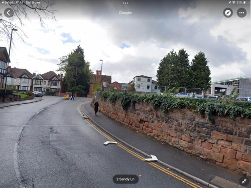
I have always wondered about the original St Nicholas Church in Radford. Not the one on Radford Road but the one in St Nicholas Street. Just looking at some of the old maps online, I only just noticed that the site's marked on the corner of St Nicholas Street and Sandy Lane. I now realise the stone wall that goes all round the corner must have been round the church. I looked out of the window of the EMEB many years at the wall and I have just realised what it was! There doesn't seem to be anything about this church, when it was there, etc. Does anyone have any more information about it? Has there ever been any archaeology done there?
 |
| Streets and Roads - St Nicholas Street | |
|
OddSock
Coventry |
5 of 35
Sun 9th Jan 2022 12:46pm
Hi Annewiggy,
I've just looked on Coventry Digital - punch in 'Sandy Lane' into their search box, and you'll find an interesting Ordnance Survey map from 1887, showing a little bit more detail?
The 1905 one is even better!
OddSock
OddSock: Particularly interested in the family surnames Cowley, Shale, & Pratt in Coventry!
|
| Streets and Roads - St Nicholas Street | |
|
Annewiggy
Tamworth |
6 of 35
Sun 9th Jan 2022 1:01pm
Thanks Oddsock, just been looking at them, there are some wonderful maps on there. The Vicarage was quite a big building as well, all gone. There is a wonderful one which I think is a fire plan that shows the whole area as big houses and gardens, no row of houses in Sandy Lane.
|
| Streets and Roads - St Nicholas Street | |
|
OddSock
Coventry |
7 of 35
Sun 9th Jan 2022 1:07pm
Happy to be of help - I've walked past that wall so many times myself! Those old maps suggest it was quite a well-to-do area, judging by the size of the properties and the grounds they stood in.
Have you searched 'St Nicholas Church' on Coventry Digital - if it's the same one, it claims it was destroyed in the blitz?? Some good images of it.
OddSock: Particularly interested in the family surnames Cowley, Shale, & Pratt in Coventry!
|
| Streets and Roads - St Nicholas Street | |
|
Midland Red
|
8 of 35
Sun 9th Jan 2022 1:12pm
That would be the one on Radford Road, OddSock - forum thread
|
| Streets and Roads - St Nicholas Street | |
|
OddSock
Coventry |
9 of 35
Sun 9th Jan 2022 1:16pm
I bow to your knowledge MR - too eager, that's always been my problem!!
 OddSock: Particularly interested in the family surnames Cowley, Shale, & Pratt in Coventry!
|
| Streets and Roads - St Nicholas Street | |
|
Annewiggy
Tamworth |
10 of 35
Sun 9th Jan 2022 1:18pm
Yes, the one destroyed in the Blitz was next to where the new one was built on the Radford Road opposite where Lidl is now. There is still a wall and a gateway there on the Radford Road. I always did wonder why it was so far away from St Nicholas Street! When I worked in Sandy Lane there were industrial units on that corner. Looking on Google Maps now, it is a building site. I wonder if they will take a closer look before they build on it again.
|
| Streets and Roads - St Nicholas Street | |
|
Helen F
Warrington |
11 of 35
Sun 9th Jan 2022 5:27pm
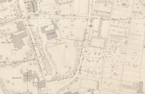
The Bradford Map 1749 puts the churchyard for St Nicholas at the junction of St Nicholas Street and the Radford Road. It shows most of the areas bounded by hedges not walls. It doesn't go far enough north to show either the vicarage or a church. There is a building directly on St Nicholas Street in the location where St Nicholas Place is on later maps. The vicarage is called Trinity Vicarage.
There was certainly some rough archaeology in the area because it was thought the St Osburga nunnery might have been in that location. I don't think they found anything relating to that but they may have located St Nicholas church.
I'll add that it was a wealthy area but not developed until the late 1700s, early 1800s.
|
| Streets and Roads - St Nicholas Street | |
|
Helen F
Warrington |
12 of 35
Sun 9th Jan 2022 5:53pm
The wall around the area might have partly come from remains of the city wall but on the 1749 map Barr's Hill is a large mound. In 1807 it was a smaller mound and the bottom end of the Radford Road and St Nicholas Street has a bit of wall. In 1850 Barr's Hill is a sandstone quarry and there are loads of walls. In 1908 the quarry has been filled in and the area cleared. So when you look at the wall you're looking at what is left of Barr's Hill.
Where Barr's Hill was.
It looks like they never built over the quarry.
|
| Streets and Roads - St Nicholas Street | |
|
Annewiggy
Tamworth |
13 of 35
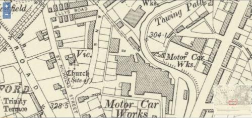
Sun 9th Jan 2022 6:06pm
Hi Helen, this is a map from Coventry Digital it shows the vicarage and the site of the church
 The wall I am referring to is this one. The wall continues round into St Nicholas Street.
 |
| Streets and Roads - St Nicholas Street | |
|
Helen F
Warrington |
14 of 35
Sun 9th Jan 2022 6:22pm
Hi Anne, I was just wondering why the church was so far away from the churchyard.
There seems to be walls along both the Radford Road and St Nicholas Street dating from between 1807 and 1850, so even a wall built in 1850 would be 170 years old. I haven't got a map of the vicarage going back further than 1850 so I don't know how much older one round that site might be.
|
| Streets and Roads - St Nicholas Street | |
|
Annewiggy
Tamworth |
15 of 35
Sun 9th Jan 2022 6:38pm
Where was the churchyard, Helen?
|
| Streets and Roads - St Nicholas Street | |

Website & counter by Rob Orland © 2026
