Helen F
Warrington
|
1 of 15
Sat 22nd Jun 2019 5:57pm
While looking for the location of Mr Wright's house my sister kindly offered to look at the items held by the British Library about Coventry and Mr Wright's house raffle in particular. She took photos of the 1731 South Prospect at the same time and when she sent them to me she threw me a bit of a curve ball. She said 'did you notice the big house on the skyline with the number 2 that in the key is 'New House'? I confess I hadn't noticed it at all  Might it be the house I was looking for as the advert said the house was new. Perhaps the map was merely an artists impression by someone who didn't know what it was going to look like and had just put something in to indicate where the new house was going to be? It seemed annoyingly plausible. The top picture is a rough blow up of the house on the Hill.
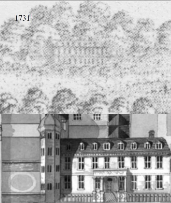
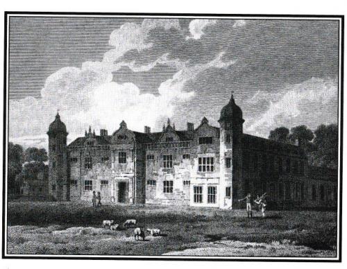
The picture below that is labelled New House Radford (search in the library pictures for 3 images of the house). A much better fit than Mr Wright's house give or take the Tudor tower with the cupola. The 3 Tudor wings were built in 1576 by John Hales, the son of the nephew (also John Hales) of the original John Hales who acquired the land from the priories. The third wing was built in about 1700, in time to be captured in the South Prospect. The house was owned by a number of people. New House was sold in the early 17th century to Sir Richard Burnaby. It passed through the hands of a Mr. Cooke, of Sir Christopher Yelverton, who was the owner of it in 1640, and of George Bohun, and by 1730 had descended to Gilbert Clarke, husband of Bohun's daughter, Susan. The house was demolished in 1778 and another erected on the site; in the early 19th century this was owned and occupied by a Mr Joseph Smith and then possibly passed to his son Mr Joseph [II] Smith or maybe George Eld Smith? After which I don't know what happened to it.
The pictures indicate the house stood back from the corner of 'The Coventry Road' and 'The road to Whitmore Park' and the new wing would have faced SSE in keeping with the South Prospect. Exactly which roads these were is debatable. The documentation calls the house Newhouse Keresley in a number of records it's referred to as Hales Place. Wherever it is, it must have been visible from the south of the city.
The question is - where was it? |
|
Buildings -
Photo poser - New House, Radford or Keresley
|
Annewiggy
Tamworth
|
2 of 15
Sat 22nd Jun 2019 8:37pm
David McGrory mentions this house in his book "The Illustrated History of Coventry Suburbs". He describes it as facing the Keresley Road, surrounded by formal gardens decorated with classic statues. It had 150 windows with views of the gardens and surrounding countyside including an area on the north side called "The Wilderness" and the three spires in the south (so must have been fairly high up. I have a copy of the map of the South Prospect 1731 and the house marked no.2 does have a lot of Windows!). That house was demolished in 1778 and he says an advert in 1779 in the Coventry Mercury had materials of the house for sale (Neil, another source for the ARBOUR?).
McGrory then says that all that remained after the demolition were the Keresley Road entrance pillars surmounted by balls. Later a small "comfortable" residence was built which belonged to the Hopkins and Smith families until 1816.
Later Abraham Barbery Herbert acquired it, enlarged it and renamed it "Moat House". This building was demolished in the late 1920's and housing sprang up. I am sure I have read somewhere that it was near the junction of Tamworth Road and the Keresley Road just past the Old Shepherd and the grass area that comes to a V between the 2 roads is something to do with it.
I have copied the picture from his book but will remove it shortly. The side of the house looks more like the drawing on the map.
|
|
Buildings -
Photo poser - New House, Radford or Keresley
|
Annewiggy
Tamworth
|
3 of 15
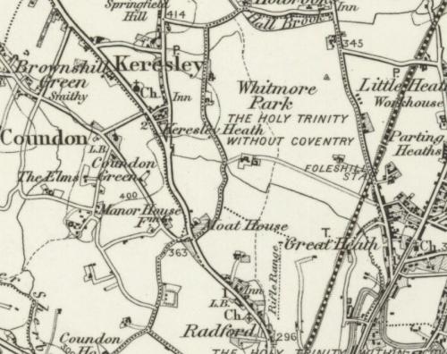
Sat 22nd Jun 2019 8:52pm
Surprisingly this 1899 map shows the Moat House more south than I thought, more on the junction of Brownshill Green Road and Radford Road, just after what we used to call the High Mounts on the Radford Road.
|
|
Buildings -
Photo poser - New House, Radford or Keresley
|
Annewiggy
Tamworth
|
4 of 15
Sat 22nd Jun 2019 8:56pm
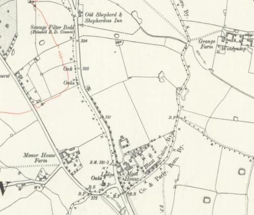
Even better, 1912
|
|
Buildings -
Photo poser - New House, Radford or Keresley
|
Helen F
Warrington
Thread starter
|
5 of 15
Sat 22nd Jun 2019 9:20pm
My thanks Anne.  It was one of the places I thought it could be but it's a bit further out than I thought it could still be seen. It ties in with the references to it being a Keresley rather than Radford. |
|
Buildings -
Photo poser - New House, Radford or Keresley
|
Annewiggy
Tamworth
|
6 of 15
Sat 22nd Jun 2019 9:50pm
I was pleased to find the info Helen, I have always wondered where the New House was. As I said I always thought it was a little further north. I could not imagine how such a large place could disappear but looking at the housing that was built there it is easy to see. I have never really thought where Radford finishes and Keresley starts but now I know! It must have been a lovely place then.
|
|
Buildings -
Photo poser - New House, Radford or Keresley
|
Annewiggy
Tamworth
|
7 of 15
Sat 22nd Jun 2019 10:20pm
Just doing a Google search for New House I came across this site - Coventry and Warwickshire Astronomical Society.
It actually has a picture of a map showing New House, but will also be of interest to anyone interested in things astronomical. |
|
Buildings -
Photo poser - New House, Radford or Keresley
|
Helen F
Warrington
Thread starter
|
8 of 15
Sat 22nd Jun 2019 11:37pm
I don't think that the house on the hill can be that New House. It would be too far away.
|
|
Buildings -
Photo poser - New House, Radford or Keresley
|
Prof
Gloucester
|
9 of 15
Sun 23rd Jun 2019 8:08am
I always found New House references to it being in Keresley.
|
|
Buildings -
Photo poser - New House, Radford or Keresley
|
Rob Orland
Historic Coventry
|
10 of 15
Sun 23rd Jun 2019 10:26am
To confirm (I hope) what you've shown on the maps above, I'm pretty sure that on a walkabout some years ago with David McGrory, he pointed to this location on Google Maps as the place where New House once stood. (I've just remembered to check in his 2011 Then & Now book, and indeed that is the location.) |
|
Buildings -
Photo poser - New House, Radford or Keresley
|
Annewiggy
Tamworth
|
11 of 15
Sun 23rd Jun 2019 10:51am
That is exactly where I would have put it Rob, and the answer to Prof's question is that is where Radford ends and Keresley begins. I have only just realised that as what I have always thought of Keresley is actually Keresley Village. In my teens I went to a party on the Keresley Road in house a young man had inherited from his parents. He also owned another house on that corner, I can't remember exactly what was there but the houses were pulled down to build those flats, that would have been in the 1960's.
|
|
Buildings -
Photo poser - New House, Radford or Keresley
|
Helen F
Warrington
Thread starter
|
12 of 15
Sun 23rd Jun 2019 11:00am
Sorted
The next questions then are - could a house in that location be seen from where the south prospect was drawn? Was it drawn in as artistic license? Was it a different house? If so, what was it? |
|
Buildings -
Photo poser - New House, Radford or Keresley
|
Annewiggy
Tamworth
|
13 of 15
Sun 23rd Jun 2019 1:18pm
I think there must be a lot of artistic licence on these prospect maps. I can't think of anywhere in the south that all of that would be visible. Would the whole of St Michael's and Holy Trinity be visible like that. Looking at the picture Spon Street is going off to the left from Bablake Church and Spon Gate. Above that is another row of trees which could be Holyhead Road, there is a windmill marked which is probably the one at Allesley which puts New House in the right direction. I think it was the only important house in the area at that time, would you have another one at that time. It does also say there were good views from the windows and they could see the spires. It is difficult to imagine a large house on its own in that position as it is so built up as it is now but it has my vote Helen |
|
Buildings -
Photo poser - New House, Radford or Keresley
|
Helen F
Warrington
Thread starter
|
14 of 15
Sun 23rd Jun 2019 6:53pm
I'm not sure what could be seen. The landscape now is very different. If you think, the ring road is taller than... well it's probably taller than St Mary's Hall and would dwarf the old city wall. Even ignoring the taller buildings, an ordinary 2 storey is taller than the average house when the panorama was created. There are even more trees. Sightlines are no more.
Originally there was a bump to the south of the railway station I think. I suppose if I pulled my finger out and created the raw landscape for the 3D model I'd know what could be seen.  |
|
Buildings -
Photo poser - New House, Radford or Keresley
|
Helen F
Warrington
Thread starter
|
15 of 15
Mon 24th Jun 2019 2:31pm
From British History Online
Part 1
1332 the priory obtained a licence to empark 436 acres of wood and waste, and added it to its earlier acquisitions to form the manor and park of Whitmore, possibly in imitation of Cheylesmore Park south of the city. A small part of the park lay in Hasilwood and so in Foleshill parish, but the greater part was determined to be several to the priory by the agreement of 1355. It was administered as an independent unit in 1410-11, although still said to be in Radford, but the positions were reversed by 1538-9 when the priory's property in Radford was described as part of Whitmore. There were two houses, those which had been Roger Locard's and Henry Beaufitz's, and a lodge in the park in 1410-11. Although used for hunting much of the land remained arable. The park was elaborately ditched and fenced, but the citizens of Coventry frequently trespassed there in the 15th century.
The grange or manor of Whitmore was leased for 21 years by the Crown to Michael Cameswell, possibly a relation of the last prior, in 1539. The reversion was granted to Sir Ralph Sadler in 1547, and he in the same year granted it to John Hales. The rent to the Crown at that time included a payment for the tithes. At his death in 1572 John Hales devised Whitmore to his nephew John Hales, and in 1586 the second John built 'a very fair house' called New House there.
New House was sold in the early 17th century to Sir Richard Burnaby. It passed through the hands of a Mr. Cooke, of Sir Christopher Yelverton, who was the owner of it in 1640, and of George Bohun, and by 1730 had descended to Gilbert Clarke, husband of Bohun's daughter, Susan. The house built by John Hales in 1586 was a stone mansion with a long front flanked by polygonal domed turrets. In the centre was a two-storied porch surmounted by a curvilinear gable; there were similar gables to the dormer windows behind a balustraded parapet. At the back of this range an additional wing was built about 1700. The house was demolished in 1778 and another erected on the site; in the early 19th century this was owned and occupied by a Mr. Smith.
The manor of Whitmore was retained by the Hales family until 1720, when it was sold to John Montagu, Duke of Montagu. Montagu sold it to Richard Hill in 1722, and it was held by the Hill family until sold by them in 1806; it was later acquired by a Mr. Lee.
The principal estate in the middle of the 19th century was that of Edward Phillips, who held Whitmore Hall (possibly the rebuilt New Hall) and 148 acres of land. Other estates in 1846 were those of R. H. Lamb (175 a.), Thomas Sheepshanks (116 a.), and John Hollick (99 a.). Miss Phillips was still living in Whitmore Hall in 1875. The four groups of farm buildings in the park in 1887 correspond with the holdings of Phillips in the north-west, Lamb in the west, Hollick in the east, and Sheepshanks in the north-east.
During and immediately after the First World War a number of factories, hostels for factory workers, and a corporation housing estate were built in the east of the park. The largest factory was that of the Dunlop Rim and Wheel Company, on the site of Hollick's farm, which employed 1,400 workers in 1933. In 1950 there were in addition to two Dunlop factories, the factories of the Albion Drop Forgings Company, the Brett Patent Lifter Company, the British Piston Ring Company, Motor Panels, Unbrako, and timber, felt, and upholstery works. The remainder of the park was occupied by housing after the Second World War, notably by Monks Park, a large corporation estate of 335 dwellings which was awarded a housing medal by the Ministry of Housing and Local Government. It consists of two-storied terraced houses built round a series of square greens or closes.
Part 2
The other large estate in Keresley in the 1840s was that of T. B. Troughton, with the New House at the extreme south of the hamlet and 203 acres attached to it. The origins of Troughton's estate are obscure, but some evidence suggests that it represents the remains of Coventry Priory's holding. The estate occupied much of the former priory waste in the southern tip of the parish and along Tamworth Road, and covered the area of the field, Netherscotshill, which the priory had had in hand in 1410-11. Part of Troughton's estate, and Lamb's Scotch Hill farm immediately to the north, were the only parts of Keresley on which the tithes were already merged in 1847, an arrangement which may have been made by the priory. When the New House estate was first mentioned in the mid 17th century its occupier was a Mr. Stroud who, as would be natural for the tenant of former priory land, was not among those paying dues to the Cheylesmore court at that time. By the late 19th century the New House had been given the name of the Moat House, apparently through confusion with the farm in Coundon nearby. The Keresley Moat House became the residence of several prominent Coventry citizens, among them P. J. Muntz and Sidney Cash. It was demolished about 1930 when the area was developed for building.
So were there two manor houses? There was certainly a manor house and a farm. |
|
Buildings -
Photo poser - New House, Radford or Keresley
|


