Andydtow
Kenilworth
|
1 of 32
Thu 5th Apr 2018 8:52pm
There appears to be no specific heading for this street. It does appear under Bishop St. but no one seems to know its exact location. King St. ran from the junction of Bishop St in a westerly direction to its junction with Abbott's Lane and Upper Well St. by the Hill Cross Tavern. It was only about 200 yards long and at its junction formed a busy junction with St Nicholas St, Leicester Row and Leicester St. This junction was controlled by a police constable on duty from 7.0am until 9.0pm on an hour on and hour off basis. On the approach to the junction with Bishop St there were a row of terraced houses on the right and one of these was used as either the Brasworkers club or The Coachmakers club. On the left was the Dalton and Barton textile factory. I know this because in 1951 I worked there for a while before I joined the Coventry City police cadets and my father was the Chief Cashier. They mainly made medal ribbons. The factory moved to Mason Rd in the late 50s and then they went to the Forest of Dean where they went into liquidation. The King St site was then used by the Co Op as a warehouse and what was left of the site after the Ring Road was built is now occupied by Wickes.
|
|
Streets and Roads -
King Street
|
NeilsYard
Coventry
|
2 of 32
Tue 10th Apr 2018 5:35pm
Yes Andy - Rob has a couple of good shots of the Castle Hotel/Inn on here which was on King Street - referenced in other threads -
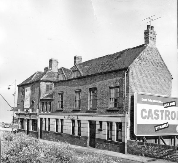
This one shows the post-war junction with Bishop Street -
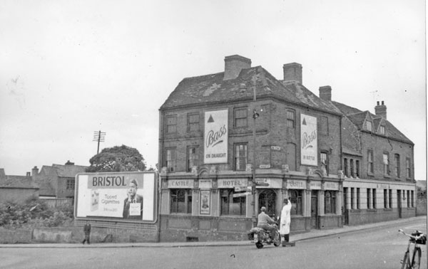
You can see that same corner here pre-war looking south straight down Bishop Street - The Hotel on the very right - along with the 'King Street' road sign - and 'that' Policeman 
 |
|
Streets and Roads -
King Street
|
Kaga simpson
Peacehaven, East Sussex
|
3 of 32
Wed 11th Apr 2018 10:44am
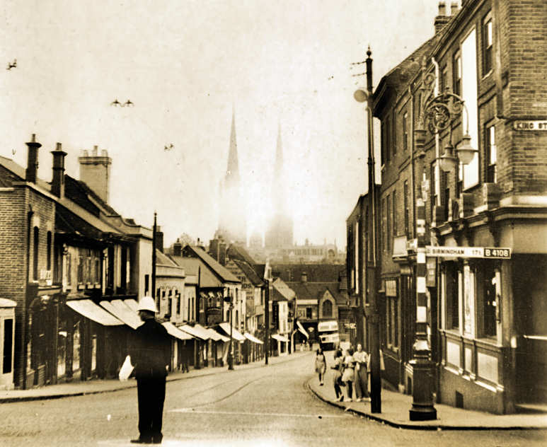
You can see from this picture above how the trams had trouble climbing Bishop Street, some wag asked the policeman to help give us a push. |
|
Streets and Roads -
King Street
|
CovPoliceHistory
Coventry
|
4 of 32
Wed 11th Apr 2018 2:35pm
April 1900, City Engineer Joseph. E. Swindlehurst, was instructed to purchase 3 fire escape ladders. One of which was to be sited in King Street.
This is the well known one sited in Broadgate:
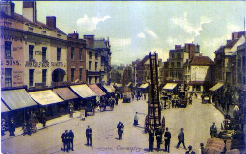
The location of the 3rd is known, however I'm still searching for a picture of it, as with that of the one in King Street.
|
|
Streets and Roads -
King Street
|
Harrier
Coventry
|
5 of 32
Wed 11th Apr 2018 8:16pm
On 5th Apr 2018 8:52pm, Andydtow said:
On the approach to the junction with Bishop St there were a row of terraced houses on the right and one of these was used as either the Brasworkers club or The Coachmakers club. On the left was the Dalton and Barton textile factory. I know this because in 1951 I worked there for a while before I joined the Coventry City police cadets and my father was the Chief Cashier. They mainly made medal ribbons. The factory moved to Mason Rd in the late 50s and then they went to the Forest of Dean where they went into liquidation.
In actual fact before they folded, David Wright who worked for the company, bought the military side of the business and the machinery and moved to Brighouse Mill, Haworth, in Yorkshire. I was staying about 100 yards from the mill over the weekend just gone, and it 'still seems in fine fettle.' The company is called Wyedean ... River WYE and the Forest of DEAN. Geddit? |
|
Streets and Roads -
King Street
|
Kaga simpson
Peacehaven, East Sussex
|
6 of 32
Sun 16th Jun 2019 1:20pm
King Street originally was a very narrow walk outside the city walls - at the commencement of the century and for a time was known as 'New Rents' from several buildings being erected there by the King family of Radford, who about the year 1675 brought the water from the well in Kings Orchard in leaden pipes into a stone trough, and then on to the malthouse in Well Street. On a large granite rock bore the initials of the King family and dates.
This was found when they built Radford Sewage Farm. |
|
Streets and Roads -
King Street
|
NeilsYard
Coventry
|
7 of 32
Thu 19th Oct 2023 3:25pm
Loving the latest Tomlinson updates Ben! Intrigued by this one - I thought King Street had completely gone by the Ring Road but looks like a lovely building on the right here - possibly No.27 looking at old maps. Seems to have been right by St Nicholas Mill - right where Wickes is today -
|
|
Streets and Roads -
King Street
|
marathonman
Coventry
|
8 of 32
Fri 20th Oct 2023 3:39pm
The house belonged to The Coventry And District Co-Operative Society. It was used by the education department in the early 70's.
On the same site was the Furniture and Electrical warehouses, and car parking for those who worked at the Co-Op on Corporation Street.
It all got knocked down and made way for Wickes. |
|
Streets and Roads -
King Street
|
NeilsYard
Coventry
|
9 of 32
Fri 20th Oct 2023 4:08pm
Thanks marathonman although I didn't think Wickes had been there that long. I can't remember it /what was there before? Welcome to the site/forum btw! |
|
Streets and Roads -
King Street
|
NeilsYard
Coventry
|
10 of 32
Wed 10th Apr 2024 4:15pm
I think you can see some remains of King Street buildings on this one - including the one I mentioned in post#7 -
|
|
Streets and Roads -
King Street
|
|
HamelCooke
|
11 of 32
Fri 25th Oct 2024 5:00pm
|
|
Helen F
Warrington
|
12 of 32
Fri 25th Oct 2024 5:31pm
Hi HamelCooke, welcome to the forum 
I can't immediately put my fingers on images of King Street as we tend to add pictures that people are looking for. Nothing springs to mind but I'll keep my eye open. There are pictures from after the bombing that don't necessarily have a decent tag. You often find bits on pictures looking over wider areas. There is a pretty poor aerial view from before the war.
And part of the start of King Street.
Not very helpful, sorry.
If you haven't already, get a log into Coventry Digital and have a good sort through. New stuff still being added and I know that a lot of the bomb damage stuff is still pending. |
|
Streets and Roads -
King Street
|
NeilsYard
Coventry
|
13 of 32
Fri 25th Oct 2024 6:02pm
Yes welcome HamelCooke. To add to what Helen says - King Street was fairly poorly captured by the camera so there are not many images of it, especially at ground level.
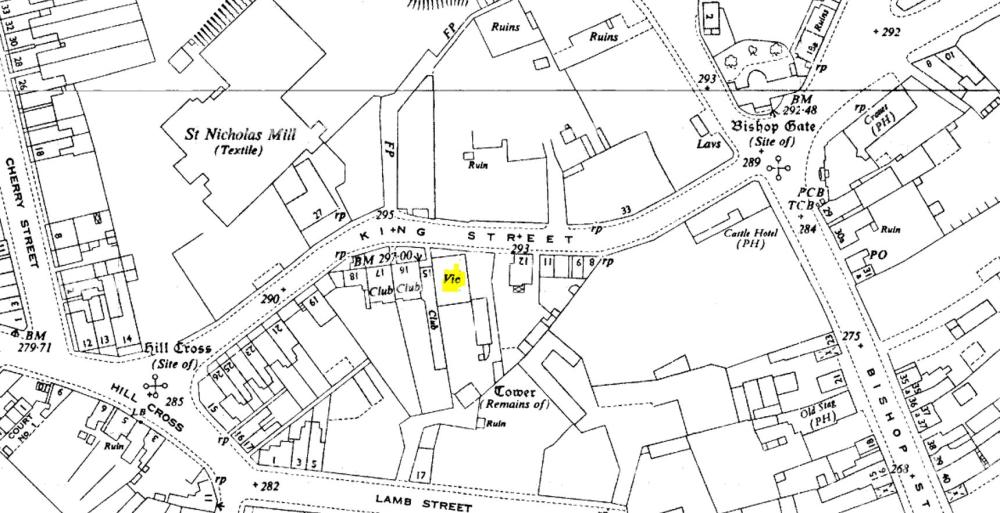
I'm presuming looking at this 1950 map that No.14 was the one marked here - Guessing Vic is Vicarage? IIRC the Castle Inn was there until the 60s when it was removed for the construction of the Ring Road -
|
|
Streets and Roads -
King Street
|
Mick Strong
Coventry
|
14 of 32
Fri 25th Oct 2024 7:10pm
On 25th Oct 2024 5:31pm, Helen F said:
This is a very different picture of The Castle to the one in A Thousand Years of Coventry Pubs (page 56)
Any info anyone? |
|
Streets and Roads -
King Street
|
Helen F
Warrington
|
15 of 32
Fri 25th Oct 2024 7:28pm
Are you sure that it was the one at the top of Bishop Street? There was more than one. |
|
Streets and Roads -
King Street
|

