Annewiggy
Tamworth
|
76 of 276
Mon 7th Sep 2015 3:20pm
I have come across this picture in a book called "Historic Warwickshire" dated 1893. It was used to illustrate the area in the chapter about the combat to be fought between the Duke of Hereford and Thomas Mowbray on 16th September 1397. The title says it is Old Bridge, Gosford Green. None of the maps I have seen show buildings like this by Gosford Green and no sign of a bridge. Maybe it's Gosford Street. Any ideas?

|
|
Streets and Roads -
Gosford Street
|
Midland Red
|
77 of 276
Mon 7th Sep 2015 3:50pm
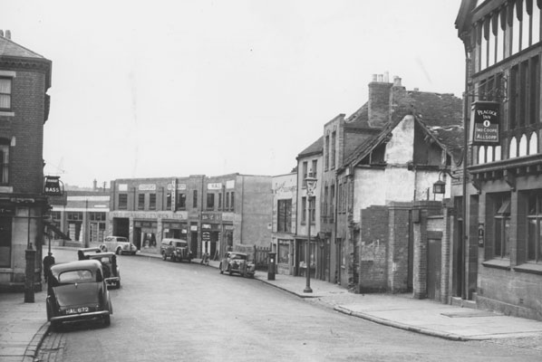
I would think this photo earlier in this thread will show the location
 |
|
Streets and Roads -
Gosford Street
|
dutchman
Spon End
|
78 of 276
Mon 7th Sep 2015 9:41pm
On 7th Sep 2015 3:20pm, Annewiggy said:
I have come across this picture in a book called "Historic Warwickshire" dated 1893. It was used to illustrate the area in the chapter about the combat to be fought between the Duke of Hereford and Thomas Mowbray on the 16th September 1397. The title says it is Old Bridge, Gosford Green. None of the maps I have seen show buildings like this by Gosford Green and no sign of a bridge. Maybe it's Gosford Street. Any Ideas ?

Yes it is.
There was also another bridge fifty yards further on but still nowhere near Gosford Green,
|
|
Streets and Roads -
Gosford Street
|
dutchman
Spon End
|
79 of 276
Mon 7th Sep 2015 9:52pm
On 7th Sep 2015 3:50pm, Midland Red said:
I would think this photo earlier in this thread will show the location

The Sherbourne ran directly under the archway of Pearson's tyre showroom in that picture, just this side of Astley's warehouse.
|
|
Streets and Roads -
Gosford Street
|
heathite
Coventry
|
80 of 276
Tue 8th Sep 2015 9:42am

On 7th Sep 2015 3:20pm, Annewiggy said:
I have come across this picture in a book called "Historic Warwickshire" dated 1893. It was used to illustrate the area in the chapter about the combat to be fought between the Duke of Hereford and Thomas Mowbray on the 16th September 1397. The title says it is Old Bridge, Gosford Green. None of the maps I have seen show buildings like this by Gosford Green and no sign of a bridge. Maybe it's Gosford Street. Any Ideas ?

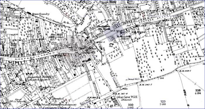
Hi all, re: Annewiggy's picture from 'Historic warwickshire', I think Anne is spot on when she suggests it is from Gosford Street.
If you take a look at the 1889 map and place yourself on Gosford Street facing the grey area, you can see the narrowing and curving of the road. Fortunately the mappers have included the Post Office box which can be seen clearer on the enlarged picture. The grey rectangle on the first picture ids the junction with Lower Ford St.
Also the 'Sherbourne Dye Works' is identified.
Very interesting, thank you for that picture Anne. |
|
Streets and Roads -
Gosford Street
|
heathite
Coventry
|
81 of 276
Tue 8th Sep 2015 9:44am
|
|
Streets and Roads -
Gosford Street
|
Annewiggy
Tamworth
|
82 of 276
Tue 8th Sep 2015 12:01pm
Thank you all, they have obviously got it wrong in the book. |
|
Streets and Roads -
Gosford Street
|
Helen F
Warrington
|
83 of 276
Tue 8th Sep 2015 7:27pm
Nice picture Anne. The building second from the right is the Anchorsmith. Only other images I've seen are sketches.
The river runs under the wall between the small gable facing the road building (on the right) and the top shops beyond. |
|
Streets and Roads -
Gosford Street
|
|
Annewiggy
|
84 of 276
Tue 8th Sep 2015 7:37pm
|
|
|
Helen F
|
85 of 276
Tue 8th Sep 2015 8:57pm
|
|
Prof
Gloucester
|
86 of 276
Wed 9th Sep 2015 12:04pm
Wonderful to see this picture of Gosford St with the post-box clearly delineated. The post office must be there on the left hand side. In the centre is what was Luckmans in my childhood, second hand books I think or antiques. This is showing where my grandmother was born. Thanks very much. |
|
Streets and Roads -
Gosford Street
|
Prof
Gloucester
|
87 of 276
Wed 9th Sep 2015 12:10pm
Thank you Helen F. The birthplace of my grandmother was a court at 35 Gosford St. I think the numbering was not alternate as is usual today, so it would have been on the LH side going from town. |
|
Streets and Roads -
Gosford Street
|
Annewiggy
Tamworth
|
88 of 276
Wed 9th Sep 2015 2:04pm
I am getting confused, can you clarify something. My 1893 picture shows what looks like a postbox on the left hand side. The later picture (I think they are from about the same spot or am I wrong) shows something there that looks slightly different and the postbox is on the other side. |
|
Streets and Roads -
Gosford Street
|
dutchman
Spon End
|
89 of 276
Wed 9th Sep 2015 2:13pm
The post office moved, at first to No. 55 (I think), then to No.12 then to No.33  |
|
Streets and Roads -
Gosford Street
|
Helen F
Warrington
|
90 of 276
Wed 9th Sep 2015 2:19pm
Hi Prof
Number 35 Gosford Street was further up the hill. It was next door to the Blue Pig (number 33) which was a post office at one point. On the other side was 36, a half timbered building so either 34/35 were in the same building or 34 was part of the Blue Pig.

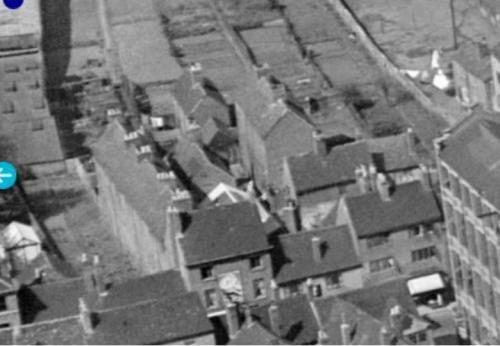
See the edge of the Morris factory on the right? The 3 storey building next to it (but on the other side of the road) is number 35. There are a number of pictures on the Britain From Above site. It's worth getting a log on because then you can zoom in. If you type Coventry Morris into the search it will get you started but there are a few other photos that might not come up of the area.
There are more images in the library pictures to the left. |
|
Streets and Roads -
Gosford Street
|
