|
Kaga simpson
Peacehaven, East Sussex |
31 of 70
Sun 22nd Sep 2019 11:02am
On the second morning after the Blitz (Sat) I stood at the top of Smithford Street up to my knees in rubble. Looking down the street there were twisted iron girders across the street, one had torn a house in half. Two decades after, I often wondered, was the Casino Cafe the house that had been torn in two?
After the rescuers came the army to sift and sort out the rubble and clear it. Of course, being a child there was a lot I didn't understand, but the soldiers unearthed a few bits of pages of singed material that had funny writing on it, and some kind of inlaid badge. My dad didn't know. I asked someone, it had been something called a visitors book of the King's Head. I threw it on the ground and a soldier shovelled it into the lorry with the rubble. |
| Streets and Roads - Fleet Street | |
|
NeilsYard
Coventry |
32 of 70
Thu 16th Jan 2020 4:56pm
A similar shot probably taken at the same time of post#53 at the junction where Fleet Street met Smithford Street - just looking slightly further west at bomb damage -

|
| Streets and Roads - Fleet Street | |
|
3Spires
SW Leicestershire |
33 of 70
Thu 16th Jan 2020 5:38pm
Great photo.
The advertising board below H Bass's offers "Palmistry and Clairvoyance"!
|
| Streets and Roads - Fleet Street | |
|
NeilsYard
Coventry |
34 of 70
Mon 18th Jan 2021 10:03am
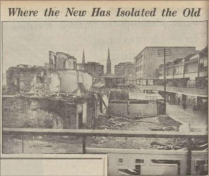
I know Rob has already seen this but how about this for a strange one. John Miles posted this one on FB recently. We think it's a fake/mock-up comparison despite the Telegraph not actually declaring it as so - it's noticeable by the railings on show on the right upper compared to other images already out there where those railings are not there yet but the whole area which is/was to become the Lower Precinct has already been cleared. What I am really interested in though is the origin, and as it seems to be a cut down photo, the full image of the older buildings shown on the left. Despite the paper alluding they are the rears of buildings on Smithford Street, most here probably already know that not much beyond where the ramp was built at Ram bridge it became Fleet Street after the West Orchard junction. So are they actually Fleet Street rears? Side by Side map comparison says they should be if the location is correct.
 |
| Streets and Roads - Fleet Street | |
|
Kaga simpson
Peacehaven, East Sussex |
35 of 70
Mon 18th Jan 2021 10:38am
NeilsYard.
Well as far as I know Fleet Street and Smithford Street were all one, same as High Street and Earl Street. In fact weren't they all one in coaching days? They were widened in about 1828 when Broadgate became widened and before the bank was there. They had the right of way, not Hertford Street. |
| Streets and Roads - Fleet Street | |
|
Helen F
Warrington |
36 of 70
Mon 18th Jan 2021 10:54am
I think that it might be a genuine photo Neil. The bit on the left, I think is the back of the south side of Fleet Street, opposite the City Arms. Note the pole.
BFA link
The different alignments of the Precinct and Smithford/Fleet Street account for the odd conjunction. We do know that they completed the south side first. |
| Streets and Roads - Fleet Street | |
|
Kaga simpson
Peacehaven, East Sussex |
37 of 70
Mon 18th Jan 2021 11:07am
Helen.
Fleet Street, the west side of the Precinct wasn't completed for five/six years after the east side, maybe more, for I left in 1961. |
| Streets and Roads - Fleet Street | |
|
Helen F
Warrington |
38 of 70
Mon 18th Jan 2021 11:12am
Yes Kaga, that would tie in with this picture from 1953 as they were working towards the west end.
BFA looking east
You can see how the Precinct will miss the old line of Fleet Street. |
| Streets and Roads - Fleet Street | |
|
NeilsYard
Coventry |
39 of 70
Mon 18th Jan 2021 11:22am
The thing is this one is dated 1958 as well? Note the upper fancy railings have not been built but any old buildings in the way of lower precinct have already been cleared?

|
| Streets and Roads - Fleet Street | |
|
Helen F
Warrington |
40 of 70
Mon 18th Jan 2021 11:25am
The photo above might be January, where the other is September. The old buildings were off to the right. |
| Streets and Roads - Fleet Street | |
|
Helen F
Warrington |
41 of 70
Mon 18th Jan 2021 11:33am
We know from this picture that they were building the cafe while those buildings still stood.

|
| Streets and Roads - Fleet Street | |
|
moriarty
allesley park coventry |
42 of 70
Mon 18th Jan 2021 12:49pm
I'm with NY on this one, immediately I saw the FB photo it looked like a mock-up!
Such a straight line dividing the two sides no boarding to shield the shoppers. Later on they always put up shuttering. However the only other things I could see was the upper railings to the left-hand side have been scratched or whitened out. |
| Streets and Roads - Fleet Street | |
|
NeilsYard
Coventry |
43 of 70
Mon 18th Jan 2021 5:52pm
Well blow me. Thanks to Malvern Carvell on FB. I'm amazed they did it that way!

|
| Streets and Roads - Fleet Street | |
|
moriarty
allesley park coventry |
44 of 70
Mon 18th Jan 2021 6:16pm
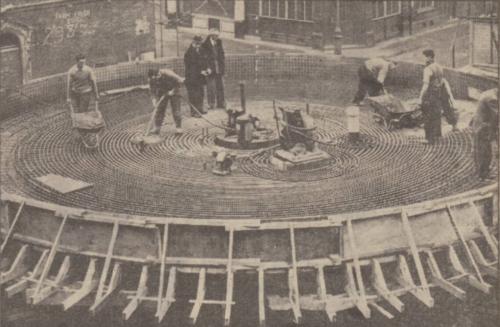
Yes, I was also completely wrong. I did realise the north side was completed later. I would have walked down there too. I'm beginning to think I was wrong on the round cafe too, but it also seems to prove safety wasn't considered with barriers to fence things off. |
| Streets and Roads - Fleet Street | |
|
Annewiggy
Tamworth |
45 of 70
Mon 18th Jan 2021 7:24pm
This picture from May 1959 does suggest there was corrugated iron round the circular cafe but none of the other pictures show it so perhaps it was just to hide it until it was nearly finished.
 |
| Streets and Roads - Fleet Street | |
Website & counter by Rob Orland © 2024
Load time: 706ms