
|
Kaga simpson
Peacehaven, East Sussex |
46 of 66
Thu 4th Jun 2020 10:45am
Built in the 13th century the manor was more of a palace for Queen (Isabella) than a castle with its great lavish park of fields and woods, its fishponds and game, but it was the most shameful time in England's history. But before its enclosure it was surrounded by a moat, part of which I believe became the 'ducking pool'.
Also a second moat outside the city walls, 'Crow moat' so called, about the year 1700, tall elms, the moat more square than oblong, whilst the island within was oblong shape, the moat (35 x 25 yards) was crossed at the eastern end by a bridge.
At the other end was a building in a enclosed field over a smaller bridge into Crow Lane, not a straight line, Albion Street not built then.
|
| Buildings - Cheylesmore Manor | |
|
Helen F
Warrington |
47 of 66
Thu 12th Aug 2021 10:03pm
I'm sure that most of you will know all this but it's new to me.
I've often read snippets about the original manor park but didn't understand it. That it was south of the wall was as far as I knew. The red line represents where experts think the Red Ditch ran. Notice how it cuts through both Little Park Street and Much Park Street. I'd wondered how they both ended up called Park Street, especially when Much Park Street kinks to the east before it joins the London Road. If they stopped officially at the Red Ditch, then the park also started there and they both enter the park. The original location of the town ditch (pre town wall) puts the manor house clearly inside the deer park and outside the town.
I'd been watching something about deer parks and their paling fence. The idea was to create a fence the deer could get into the park (free stock) but they couldn't jump out again. This involved either a tall fence with the odd break for the deer to get in with a deep hollow on the inside of them. Alternatively a lower fence could be set on top of a ramp of soil, with a steep slope or wall on the inside. Another source said that deer parks were rounded, suggesting that it used fewer palings but I'm guessing that it was to give the deer somewhere to go rather than a dead end corner, where they might panic and hurt themselves. So I looked at the maps and couldn't see the park till I zoomed out. The green line follows clear features in the landscape. The west is obvious but there are some different possibilities to the east.
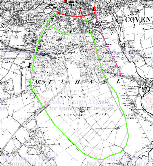 The green dotted line takes the west curve all the way to the Red Ditch near Ford's. Notice how the roads on the west side curve round the park from The Grove to Greyfriars Lane. We tend to think that the roads after the Romans were illogically non linear but just because you can't see the obstacle that shaped the road anymore it doesn't mean it wasn't there when they were laid down.
To be continued.
The green dotted line takes the west curve all the way to the Red Ditch near Ford's. Notice how the roads on the west side curve round the park from The Grove to Greyfriars Lane. We tend to think that the roads after the Romans were illogically non linear but just because you can't see the obstacle that shaped the road anymore it doesn't mean it wasn't there when they were laid down.
To be continued.
|
| Buildings - Cheylesmore Manor | |
|
Helen F
Warrington |
48 of 66
Fri 13th Aug 2021 2:41pm
Resumed. Now it gets more speculative.
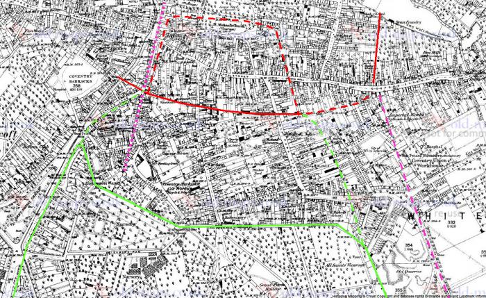 The solid green line is the post city wall extent of the park but it's probable that it originally extended to the Red Ditch. That ditch was a clear feature in the topography even as late as the early 1900s. Up the right side we have the London Road direction marked in a pink dashed line. What was the point of the road kicking west into the park and out again at the Red Ditch when there were no properties there? It would have necessitated 2 manned gates, so logically the road would have continued further north towards either Gosford Street or Jordan Well. The route is very speculative. I do know that there was a substantial ditch running north from Gosford Street (from the Mermaid) that gave rise to rumours of secret tunnels from White Friars. More likely is that it was a drainage or defensive ditch but from the exaggerated accounts it's hard to tell which or indeed how old it was. However if it was a very early defensive ditch it might be logical that the London Road once entered the city via a gate house very near the Mermaid. Once Much Park Street was extended then it became logical to cut the London Road shorter and join it up to the mostly wider street. The north ends of two park streets were narrow, in keeping with them being non significant roads to start with. It was much later that the north ends were widened to make the turns into the main street easier. All that said, the whole London Road might be a later feature and may not have had the importance it did by the time the New Gate was built.
To go back to the west route of the park fence, you see Warwick Lane curve and then the road runs straight as it becomes Greyfriars Lane. Curiously the pink dotted line shows that you can almost draw a straight line from Cheylesmore manor up to the entrance of the priory in Butchers Row. The front row of Broadgate gets in the way but wasn't there while the castle was still standing. Greyfriars Lane follows what was probably the castle/town wall (red dashes). To the north and east the boundaries of the castle/town are not very clear at all, so speculation about that side needs a big pinch of salt. The same applies to the park boundary on that side.
To be continued.
The solid green line is the post city wall extent of the park but it's probable that it originally extended to the Red Ditch. That ditch was a clear feature in the topography even as late as the early 1900s. Up the right side we have the London Road direction marked in a pink dashed line. What was the point of the road kicking west into the park and out again at the Red Ditch when there were no properties there? It would have necessitated 2 manned gates, so logically the road would have continued further north towards either Gosford Street or Jordan Well. The route is very speculative. I do know that there was a substantial ditch running north from Gosford Street (from the Mermaid) that gave rise to rumours of secret tunnels from White Friars. More likely is that it was a drainage or defensive ditch but from the exaggerated accounts it's hard to tell which or indeed how old it was. However if it was a very early defensive ditch it might be logical that the London Road once entered the city via a gate house very near the Mermaid. Once Much Park Street was extended then it became logical to cut the London Road shorter and join it up to the mostly wider street. The north ends of two park streets were narrow, in keeping with them being non significant roads to start with. It was much later that the north ends were widened to make the turns into the main street easier. All that said, the whole London Road might be a later feature and may not have had the importance it did by the time the New Gate was built.
To go back to the west route of the park fence, you see Warwick Lane curve and then the road runs straight as it becomes Greyfriars Lane. Curiously the pink dotted line shows that you can almost draw a straight line from Cheylesmore manor up to the entrance of the priory in Butchers Row. The front row of Broadgate gets in the way but wasn't there while the castle was still standing. Greyfriars Lane follows what was probably the castle/town wall (red dashes). To the north and east the boundaries of the castle/town are not very clear at all, so speculation about that side needs a big pinch of salt. The same applies to the park boundary on that side.
To be continued. |
| Buildings - Cheylesmore Manor | |
|
NeilsYard
Coventry Thread starter
|
49 of 66
Mon 22nd Aug 2022 2:47pm
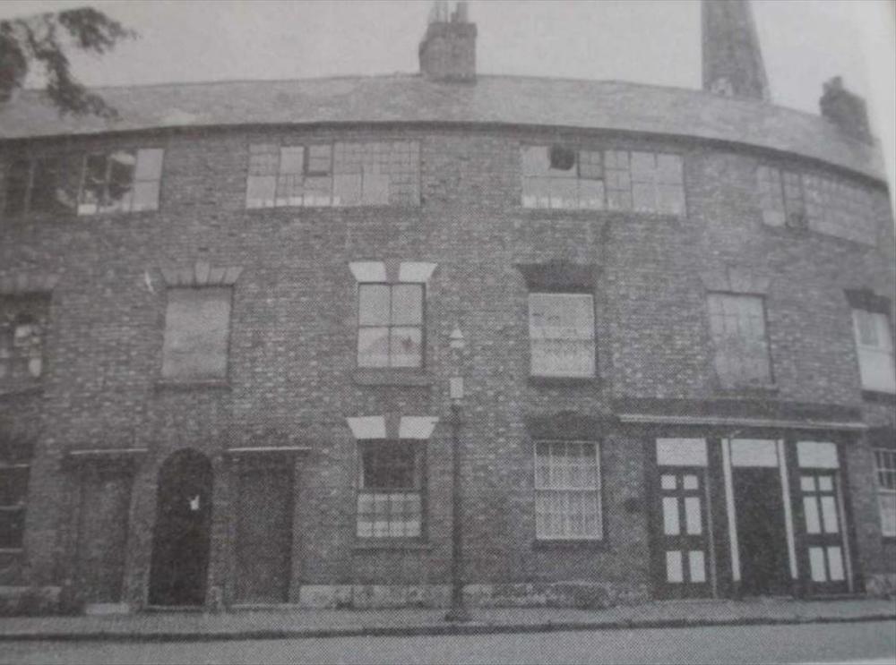
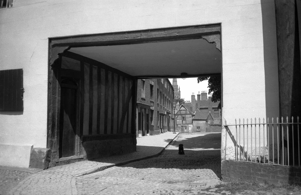
I think this is the Manor House site before restoration began, with the view towards Cheylesmore.
|
| Buildings - Cheylesmore Manor | |
|
Helen F
Warrington |
50 of 66
Mon 22nd Aug 2022 3:08pm
Since they were also part of the manor, it's a real shame they didn't keep the buildings on the right.
|
| Buildings - Cheylesmore Manor | |
|
Annewiggy
Tamworth |
51 of 66
Sun 22nd Jan 2023 12:52pm
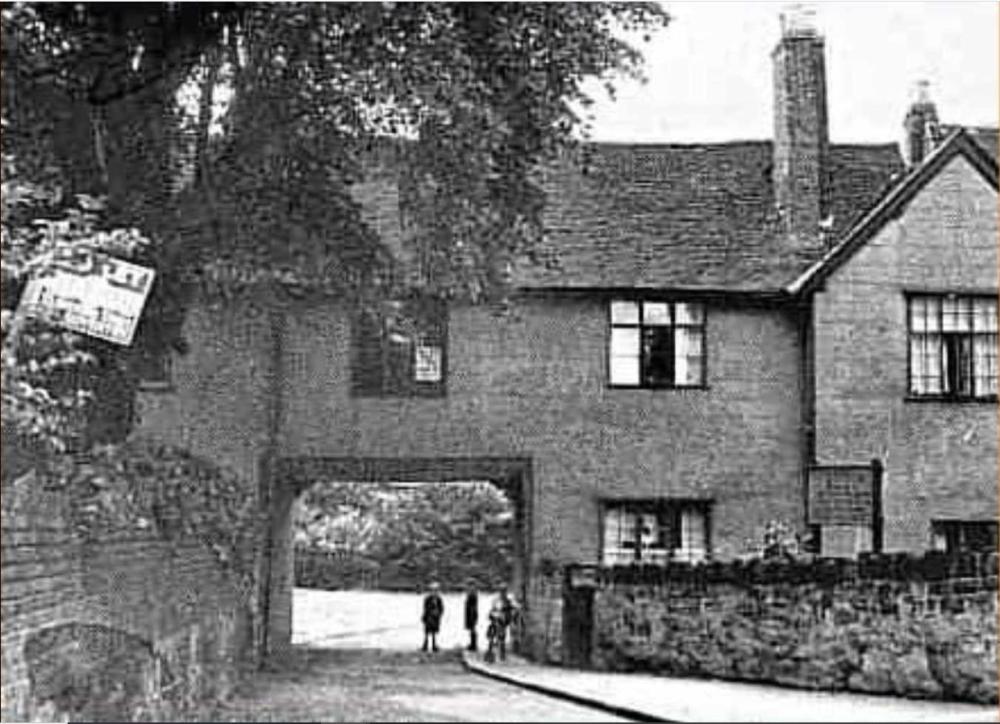
Just spotted this picture entitled "Repairing medieval woodwork 1950" on COVENTRY DIGITAL.
It is Cheylesmore Manor House. I have lots of pictures standing in front of this archway on our wedding day in 1969!
|
| Buildings - Cheylesmore Manor | |
|
NeilsYard
Coventry Thread starter
|
52 of 66
Mon 30th Oct 2023 12:14pm
Not the Manor but as it links in with the posts of the old row on Cheylesmore on this thread - a new to me face on shot of part of that row from 1960 -
|
| Buildings - Cheylesmore Manor | |
|
NeilsYard
Coventry Thread starter
|
53 of 66
Mon 27th Nov 2023 11:37am
Not 100% I'd seen this exact one before - it's been enlarged before so not totally clear -
 |
| Buildings - Cheylesmore Manor | |
|
Rob Orland
Historic Coventry |
54 of 66
Mon 27th Nov 2023 4:11pm
Yep, I certainly recognise it!!! Someone, somewhere has simply enlarged the photo I used on this Now and Then page!
 |
| Buildings - Cheylesmore Manor | |
|
NeilsYard
Coventry Thread starter
|
55 of 66
Mon 27th Nov 2023 4:50pm
Aha Sorry Rob - Dean's at it again! I'd forgotten about that page of yours though
 |
| Buildings - Cheylesmore Manor | |
|
Rob Orland
Historic Coventry |
56 of 66
Mon 27th Nov 2023 7:04pm
Haha, nothing to apologise for, Neil - we know what Dean's like!
|
| Buildings - Cheylesmore Manor | |
|
NeilsYard
Coventry Thread starter
|
57 of 66
Sun 17th Mar 2024 10:41am
Cooper Collection -
|
| Buildings - Cheylesmore Manor | |
|
Gas Centre
Perth Scotland |
58 of 66
Wed 20th Mar 2024 11:30am
I used to know Joe Connop who ran Connop Signs, he told me he was born in Cheylesmore Manor. He was probably be one of the children in one of the photos. Joe was a member of The Quadrant Club, I think he was using the club well into his eighties.
Alan H
Alan H
|
| Buildings - Cheylesmore Manor | |
|
Tony R
Australia |
59 of 66
Thu 22nd May 2025 9:09pm
Hi all,
This an enlarged detail from bk's post #101 in another thread as visible here.
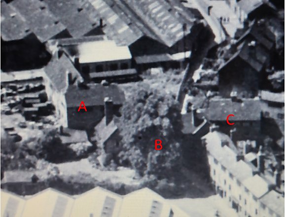 It shows the appearance of the "manor complex" shortly after the war (late 1940s perhaps) from the air, looking from the north east. I have added some labels: "A" shows the "south range" (actually more like south east, called the east range in some sources), demolished 1956/57; "B" shows the still extant gatehouse, partially obscured by a large tree; and "C" shows a building described elsewhere as "weavers' cottages" and subsequently demolished (and nowhere stated to be part of the original manor), but looks superficially a lot like a mirror image of "A"...
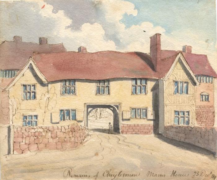
Interestingly, this 1820 painting from the Herbert Art Gallery and Museum collection shows some of the same from ground level.
It shows the appearance of the "manor complex" shortly after the war (late 1940s perhaps) from the air, looking from the north east. I have added some labels: "A" shows the "south range" (actually more like south east, called the east range in some sources), demolished 1956/57; "B" shows the still extant gatehouse, partially obscured by a large tree; and "C" shows a building described elsewhere as "weavers' cottages" and subsequently demolished (and nowhere stated to be part of the original manor), but looks superficially a lot like a mirror image of "A"...
Interestingly, this 1820 painting from the Herbert Art Gallery and Museum collection shows some of the same from ground level.
 To me it is interesting that the "south range" (A in the photograph) itself appears to consist of 2 separate portions, one at right angles to the other. What do other folks think...
Tony Rees
|
| Buildings - Cheylesmore Manor | |
|
Helen F
Warrington |
60 of 66
Thu 22nd May 2025 9:58pm
Well spotted Tony
 Yes, B is made up of two blocks... actually three because the right hand side is similar. Of A there are pictures of the demolition, showing the ancient structures inside. There are even plans and elevations. Most of the structure was north south (ish), which is why that block was referred to as the east range. It was the posh living quarters. The very first hall was almost at right angles to that, and was combined into the wall. Some say that it must have had a lean too roof but I have a theory that the south prospect that seems to show a tower as part of the manor, actually depicts the old hall. Similar to Stokesay. Records indicate that the hall was in very bad repair but that it was demolished as they were taking down the city wall after the Civil War. The hall belonged to the king, and news of its casual destruction may have been what triggered the call to end the demolition.
C wasn't a mirror image of A but the Tudor lot weren't that bothered by symmetry. I don't know how old that block was and not many pictures remain of it. The watercolour above by William Henry Brooke seem to show that it was built partly out of stone blocks. While I don't know that it's truly old because I've only seen the brick clad exterior, it does match several very old brick clad timber buildings elsewhere in the city. It was certainly within the manor wall. There was also another block on the west side, which was demolished before the 1888 map, where more modern cottages are shown in the aerial photos. Again, I don't know how old they were but they are on the 1749 map. I have copies of rough sketches of them done by kids and they look like they may have also been brick clad timber structures. I assume that these might have been staff/stable blocks. Yes, B is made up of two blocks... actually three because the right hand side is similar. Of A there are pictures of the demolition, showing the ancient structures inside. There are even plans and elevations. Most of the structure was north south (ish), which is why that block was referred to as the east range. It was the posh living quarters. The very first hall was almost at right angles to that, and was combined into the wall. Some say that it must have had a lean too roof but I have a theory that the south prospect that seems to show a tower as part of the manor, actually depicts the old hall. Similar to Stokesay. Records indicate that the hall was in very bad repair but that it was demolished as they were taking down the city wall after the Civil War. The hall belonged to the king, and news of its casual destruction may have been what triggered the call to end the demolition.
C wasn't a mirror image of A but the Tudor lot weren't that bothered by symmetry. I don't know how old that block was and not many pictures remain of it. The watercolour above by William Henry Brooke seem to show that it was built partly out of stone blocks. While I don't know that it's truly old because I've only seen the brick clad exterior, it does match several very old brick clad timber buildings elsewhere in the city. It was certainly within the manor wall. There was also another block on the west side, which was demolished before the 1888 map, where more modern cottages are shown in the aerial photos. Again, I don't know how old they were but they are on the 1749 map. I have copies of rough sketches of them done by kids and they look like they may have also been brick clad timber structures. I assume that these might have been staff/stable blocks. |
| Buildings - Cheylesmore Manor | |

Website & counter by Rob Orland © 2025
Load time: 673ms
