|
Foxcote
Warwick |
1 of 51
Fri 22nd Feb 2013 9:36am
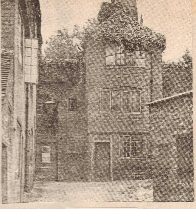
I'd like help with the location of this photograph, it purports to be a street behind the church around 1924
|
| Streets and Roads - Street behind Holy Trinity Church | |
|
AD
Allesley Park |
2 of 51
Fri 22nd Feb 2013 11:59am
At first I thought it might be looking east along Priory Row, towards where the new cathedral now stands, but the buildings don't suit the Georgian look.
Could be looking down Hill Top?
|
| Streets and Roads - Street behind Holy Trinity Church | |
|
woodford
coventry |
3 of 51
Fri 22nd Feb 2013 12:25pm
I don't know the location, but it is another reminder of how the city centre has changed! Great picture
|
| Streets and Roads - Street behind Holy Trinity Church | |
|
Annewiggy
Tamworth |
4 of 51
Fri 22nd Feb 2013 3:10pm
Here is a picture of Hill Top dated 1950. I don't think the buildings and windows are the same. If you look at street views of Trinity Lane and Priory Row the railings look the same as the ones the children on the right of your picture are standing behind.
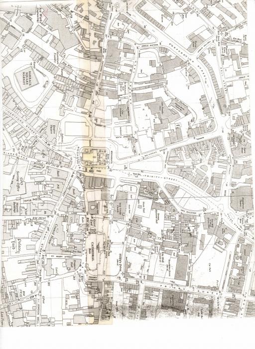
 On the map I have put on which must be about 1950's as the Lady Godiva Statue is marked but Smithford Street is still the A46 there are some buildings and a school behind what the black and white building at the top of Trinity Street. There is a graveyard marked behind them. I wonder if this is the area of your picture.
 |
| Streets and Roads - Street behind Holy Trinity Church | |
|
NormK
bulkington |
5 of 51
Fri 22nd Feb 2013 4:29pm
I remember demolishing a terrace of houses up Hill Top in the 60s. I recall one of them was all boarded up and was full of furniture, we burned everything, so God knows what antiques etc. we destroyed. We never gave it any thought at the time
Milly rules
|
| Streets and Roads - Street behind Holy Trinity Church | |
|
Foxcote
Warwick Thread starter
|
6 of 51
Fri 22nd Feb 2013 5:11pm
Thanks for the information Annewiggy, I think you are right, the railings are the clue. I shall have a good look at your map. There appears to be quite a slope on the photo. I did wonder whether Hill Top had potential but comparing your photo with mine, it just doesn't add up.
|
| Streets and Roads - Street behind Holy Trinity Church | |
|
Midland Red
|
7 of 51
Mon 7th Oct 2013 7:15pm
Just reviving this thread in case there are any fresh clues to the identity of the photo
|
| Streets and Roads - Street behind Holy Trinity Church | |
|
Rob Orland
Historic Coventry |
8 of 51
Mon 7th Oct 2013 9:34pm
I'd almost forgotten about this one! I don't think I've actually solved it, but might have something useful to go on (no, not a toilet !!).
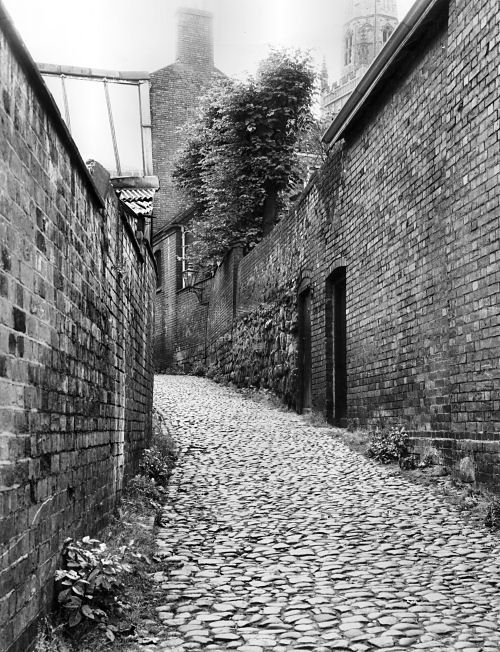
Below is a photo from Dave McGrory's "Coventry: Then & Now" book, showing a photo taken looking up Hill Top. I wonder if the mystery photo above could've been taken from within one of the "backyards" on the right, therefore looking over the rooftops of houses in Priory Row towards Trinity Spire?
 |
| Streets and Roads - Street behind Holy Trinity Church | |
|
NeilsYard
Coventry |
9 of 51
Tue 8th Oct 2013 10:35am
"By Jove!" You may have it there Rob, the line up of Holy Trinity Spire is the clue. I'll try to arm myself with a camera next time I'm in town and see if I can get anywhere near that spot, though looking at the latest Google Map Imagery that's a no-go.
|
| Streets and Roads - Street behind Holy Trinity Church | |
|
Midland Red
|
10 of 51
Tue 8th Oct 2013 12:00pm
On 7th Oct 2013 9:34pm, Rob Orland said:
Below is a photo from Dave McGrory's "Coventry: Then & Now" book, showing a photo taken looking up Hill Top. I wonder if the mystery photo above could've been taken from within one of the "backyards" on the right, therefore looking over the rooftops of houses in Priory Row towards Trinity Spire?
I think the door on the right nearest the camera was the entrance to Coventry Bridge Club, where my grandparents were regular players - I remember going there many times in the 50s 
|
| Streets and Roads - Street behind Holy Trinity Church | |
|
pallmall
Kent |
11 of 51
Tue 8th Oct 2013 12:38pm
I don't ever recall seeing anything like this in Coventry and wonder if the location given for this photo is correct. It looks to me very much like one of the old Closes or Wynds in Edinburgh.
The buildings look to be of stone rather than brick and the doorway to the left of the children is very typical of Edinburgh tenements To the right of the children, the path (or more likely steps) clearly descends beneath an arch. This descent is lit by a street lamp, just above the childrens' heads, and is also very typical of those in old photos of the Closes.
There used to be a Trinity College Church in Edinburgh and I wonder if a faded, and perhaps handwritten, location has been misinterpreted?
|
| Streets and Roads - Street behind Holy Trinity Church | |
|
Midland Red
|
12 of 51
Wed 9th Oct 2013 9:15am
I certainly agree with the above comments - it looks nothing like anywhere in Coventry that I have seen before, and I'm sure that, by now, someone on the forum would have come up with an identification
Not for the first time, Mirrorpix seems to have included an erroneous caption
|
| Streets and Roads - Street behind Holy Trinity Church | |
|
Midland Red
|
13 of 51
Wed 9th Oct 2013 9:21am
On 22nd Feb 2013 3:10pm, Annewiggy said:
Here is a picture of Hill Top dated 1950.
Struggling to clearly identify just where this photo was taken - can anyone help? 
|
| Streets and Roads - Street behind Holy Trinity Church | |
|
Dreamtime
Perth Western Australia |
14 of 51
Wed 9th Oct 2013 11:21am
That is a steeple behind it isn't it? Which doesn't help me but one of you with the 'know how' might know.
|
| Streets and Roads - Street behind Holy Trinity Church | |
|
Midland Red
|
15 of 51
Wed 9th Oct 2013 12:17pm
Trinity
|
| Streets and Roads - Street behind Holy Trinity Church | |
Website & counter by Rob Orland © 2026