NeilsYard
Coventry
|
1 of 111
Fri 4th Sep 2015 2:02am
|
|
Streets and Roads -
Spicerstoke (inc Trinity Lane)
|
Dreamtime
Perth Western Australia
|
2 of 111
Fri 4th Sep 2015 2:40am
Very interesting Neil, the times I have taken short cuts through there. I bet the tree is original too.
Thanks for that.  |
|
Streets and Roads -
Spicerstoke (inc Trinity Lane)
|
Midland Red
|
3 of 111
Fri 4th Sep 2015 11:58am
Brilliant work, Neil 
Had this photo been taken in the 1950s and early 1960s, you would have seen Canon Clitheroe's motor bike parked by the lamppost next to the wall to Holy Trinity 
|
|
Streets and Roads -
Spicerstoke (inc Trinity Lane)
|
Osmiroid
UK
|
4 of 111
Fri 4th Sep 2015 2:07pm
Supposedly a mini "quarter" of spice sellers, maybe before the old photos were taken? It doesn't look like it too much here?
|
|
Streets and Roads -
Spicerstoke (inc Trinity Lane)
|
Helen F
Warrington
|
5 of 111
Fri 4th Sep 2015 4:37pm
Nice set of images NeilsYard. I feel like I'm stepping back in time by knowing where the person who captured the image was standing. Surviving trees are almost more of a link to the past than buildings.
The area was the top end of Butcher Row so it would be a suitable place to sell spices. Didn't make the obvious connection, thanks Osmiroid.
Butcher shop in the Spicerstoke
I'm fairly sure the rare picture held up in this article was the Spicerstoke. It was next to Pope's Head Alley (the archway) and shows another butcher shop. There are a lot of photos and drawings from the other direction but very little from before the Library was built. One of the areas I've got very little of is the bit between Derby Lane and Cuckoo Lane. I assume the Spicerstoke stopped at Derby Lane. |
|
Streets and Roads -
Spicerstoke (inc Trinity Lane)
|
Midland Red
|
6 of 111
Fri 4th Sep 2015 5:48pm
Back on topic - the online list of streets mentioned above shows:
SPICER STOKE (1410-11) was the market for fresh fish and lay along the E. side of the Great Butchery, and towards the lychgate SW. of Holy Trinity Church. |
|
Streets and Roads -
Spicerstoke (inc Trinity Lane)
|
NeilsYard
Coventry
Thread starter
|
7 of 111
Fri 4th Sep 2015 9:33pm
This is the view down Derby Lane looking south - your back to Spicerstoke/Holy Trinity. The pub at the end is The Toby's Head in Pepper Lane:

And if you turned around this is the view North looking at Spicerstoke from Derby Lane - you can see the Holy Trinity railings with Trinity Lane in the very background:

The sign up high on the right is the 'Reporter Printing Works.' This amazing shot is taken from the Printing Works Yard itself looking across Derby Lane - directly at the buildings in the previous photo:

My mum's partner recalls hearing his grandfather as a boy in the 1940's/50's telling him about the whole area around Butcher Row. Even before the area was cleared in the 30's it was known even back then as being full of very ancient and old buildings. |
|
Streets and Roads -
Spicerstoke (inc Trinity Lane)
|
NeilsYard
Coventry
Thread starter
|
8 of 111
Sat 5th Sep 2015 12:49am
Helen I've just been reviewing on the forum your mystery photo from earlier this year that referenced the Spicerstoke area. Sorry I did not link the two. Did any ever find out what that tall building was at the end that survived to overlook the library?

I'm sure there was another thread that showed a later image of the area from the first photo but am struggling to find it.
Actually that Britain from above photo slightly confuses me now? From the Now and Then comparison photos - the angle of the shots appear to be in the same position as the Gulson Library is shown - but wasn't the library built around 1890? How come its not visible in my original thread photos? Map anyone?
|
|
Streets and Roads -
Spicerstoke (inc Trinity Lane)
|
NeilsYard
Coventry
Thread starter
|
9 of 111
Sat 5th Sep 2015 1:10am
OK think I've answered my own question and confused myself with angles:

|
|
Streets and Roads -
Spicerstoke (inc Trinity Lane)
|
Osmiroid
UK
|
10 of 111
Sat 5th Sep 2015 1:38am
Trinity Lane, from Priory Row - I knew I'd read it somewhere, although looking around the internet it seems to be either an area of grocers or an area of goldsmiths.
|
|
Streets and Roads -
Spicerstoke (inc Trinity Lane)
|
dutchman
Spon End
|
11 of 111
Sat 5th Sep 2015 1:48am
On 5th Sep 2015 12:49am, NeilsYard said:
Did any ever find out what that tall building was at the end that survived to overlook the library?

Yes, there was long discussion about it on here but I haven't a clue where? 
|
|
Streets and Roads -
Spicerstoke (inc Trinity Lane)
|
NeilsYard
Coventry
Thread starter
|
12 of 111
Sat 5th Sep 2015 2:07am
The map section I added was from the Goad Map of 1897. Goad was a cartographer who documented street maps for Fire insurance purposes. They included notes of material construction and usage. The spot where the tall building appears to be is purely marked as "Bk(Brick)& Timber" with no usage indicated though next door (south) is marked "Gro Whse" - which I presumed was a "Workhouse" but looking across other areas of the city appears to be Warehouse.
|
|
Streets and Roads -
Spicerstoke (inc Trinity Lane)
|
NeilsYard
Coventry
Thread starter
|
13 of 111
Sat 5th Sep 2015 2:16am
As a further aid whilst looking in to this - Found a useful tool provided by the British Library. You can open an old map from their site but within Google earth maps and make a side by side comparison with todays map. These can be moved to mark the exact spot where buildings etc. once stood.
The Vaults pub is used here to show that it stood right on the corner of todays Broadgate/Trinity street - right on the corner of Primark.
Click on Side-by-side to get the comparison.
Insurance Plan of Coventry: sheet 5 - 1897 |
|
Streets and Roads -
Spicerstoke (inc Trinity Lane)
|
Wearethemods
Aberdeenshire
|
14 of 111
Sat 5th Sep 2015 8:53am
On 5th Sep 2015 2:07am, NeilsYard said:
The spot where the tall building appears to be is purely marked as "Bk(Brick)& Timber" with no usage indicated though next door (south) is marked "Gro Whse" - which I presumed was a "Workhouse" but looking across other areas of the city appears to be Warehouse.
Hi Neil, as this was the Market area near the Coventry Cross centrepoint, it was probably the abbreviation for 'Grocers Warehouse' |
|
Streets and Roads -
Spicerstoke (inc Trinity Lane)
|
Helen F
Warrington
|
15 of 111
Sat 5th Sep 2015 11:24am
Hi Neil.
The building that survived the bombing was a replacement from round about 1921. The original can just about be seen in the earliest images from Britain From Above but all the clear images are of the brick replacement. The Pope's Head pub was within the block bounded by Broadgate, Derby Lane and the Spicerstoke.
6th comment down
More about that building and Pope's Head Alley
There is a picture on Mirrorpix of the later building. It had the sign Frank Mason and Co. E.A. (and I think I. but it could be L or J) |
|
Streets and Roads -
Spicerstoke (inc Trinity Lane)
|


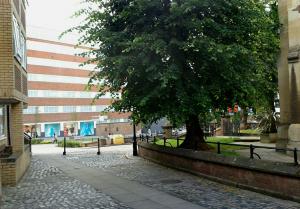
 You can see the Derby Lane sign here looking along Spicerstoke and the ALES sign here is from the Royal Vaults Pub on Broadgate/Cross Cheaping.
The building on the left here looks out to the tree and Holy Trinity - its just out of shot to the left of the first picture with the car.
You can see the Derby Lane sign here looking along Spicerstoke and the ALES sign here is from the Royal Vaults Pub on Broadgate/Cross Cheaping.
The building on the left here looks out to the tree and Holy Trinity - its just out of shot to the left of the first picture with the car.

