
|
Catshed
Old Chapelfields |
1 of 40
Mon 13th Jul 2015 11:01am
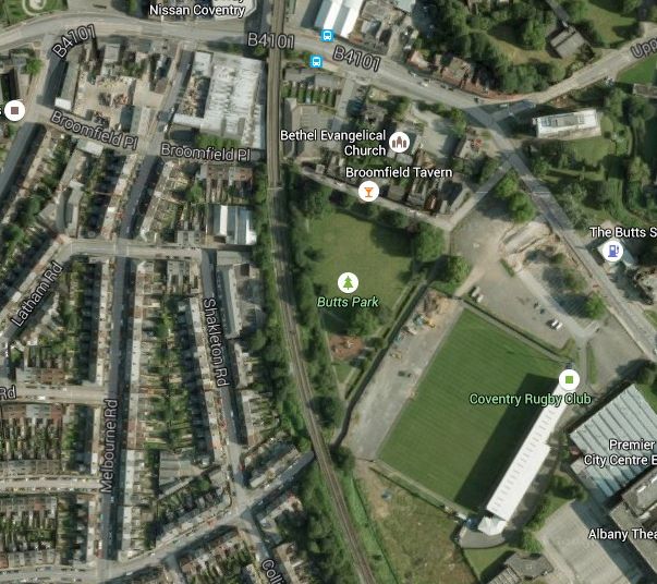
Does anyone know the correct name for the playing field by the railway line opposite the Broomfield Tavern in Spon End / Butts, some call it Broomfield Park but others call it Sovereign Park as it's on Sovereign Row.
Andy
Triumph - 'The Best Motorcycle in the World'.
|
| Memories and Nostalgia - Broomfield Park | |
|
Annewiggy
Tamworth |
2 of 40
Mon 13th Jul 2015 11:39am
Hi Andy. On Google it is called Butts Park, if that is the one.
 |
| Memories and Nostalgia - Broomfield Park | |
|
Catshed
Old Chapelfields Thread starter
|
3 of 40
Mon 13th Jul 2015 11:59am
Yes I did see that when looking, but think that it's off the mark and Butts Park is the actual rugby club (the old Velodrome), it's an odd one as older people round here call it Sovereign Park, but my generation (at 50) call it Broomfield Park but can'tfind an old map with its name on, it may have been mentioned on here before so sorry if this is an old topic
 Triumph - 'The Best Motorcycle in the World'.
|
| Memories and Nostalgia - Broomfield Park | |
|
Annewiggy
Tamworth |
4 of 40
Mon 13th Jul 2015 12:14pm
I did wonder that, sometimes Google maps are a bit off the mark. I have a map which isn't dated but must be pre war just calls it "rec Ground" which isn't much help!
|
| Memories and Nostalgia - Broomfield Park | |
|
Catshed
Old Chapelfields Thread starter
|
5 of 40
Mon 13th Jul 2015 12:27pm
Thanks for looking Annewiggy, also something else I found on a 1923 map that Broomfield Place 'now' was called Broomfield Terrace 'back then' and Broomfield Place is now Sovereign Row.

Triumph - 'The Best Motorcycle in the World'.
|
| Memories and Nostalgia - Broomfield Park | |
|
Annewiggy
Tamworth |
6 of 40
Mon 13th Jul 2015 12:50pm
It is very confusing, On the map I have which is Burrow's pointer guide map of Coventry Broomfield Place goes all across from Hearsall Lane, across Melbourne Road and under the railway. Sovereign Row is the line NW of the football ground on your map joining Sovereign Road.
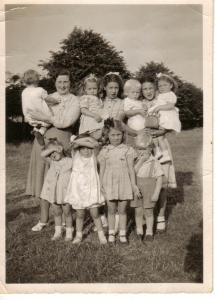
Just as a matter of interest, here is a picture that would have been taken in the park, whatever it was called in about 1948. My Grandad lived in Melbourne Road with my Auntie, Uncle and Cousin so the park would have been close to them. I am the babe in arms with her back to the camera on the left
 Just found a 1995 map, still only called "rec"
|
| Memories and Nostalgia - Broomfield Park | |
|
sally watson
coventry |
7 of 40
Mon 13th Jul 2015 1:31pm
the park was known as THE BLACK PAD, it was my local park until the age of 11, I'm 69 now and have wonderful memories of this park, happy days!
|
| Memories and Nostalgia - Broomfield Park | |
|
Harrier
Coventry |
8 of 40
Mon 13th Jul 2015 2:09pm
In my never ending search into the history of athletics in the city, I have come across references to 'Melbourne Park' where there was a semi permanent grass track in the summer months for a couple of years, but I have never been able to pin point the area around the Butts where it was located [N.B. It was neither at the Butts track nor at the Earlsdon Track], could this be an old name for the piece of land in question? The references come from the mid 1880s when there was a boom in interest in cross country running not only in Coventry but nation wide. There was as many as fourteen clubs operating within 4 miles of the city at this time and not surprisingly, it was the Melbourne Harriers who organised their track events at Melbourne Park!
Mods note: Harrier opened a thread called "Melbourne Racing Ground" - link - which may well be connected to this thread
 |
| Memories and Nostalgia - Broomfield Park | |
| Dreamtime |
9 of 40
Mon 13th Jul 2015 3:33pm
|
|
Catshed
Old Chapelfields Thread starter
|
10 of 40
Mon 13th Jul 2015 4:43pm
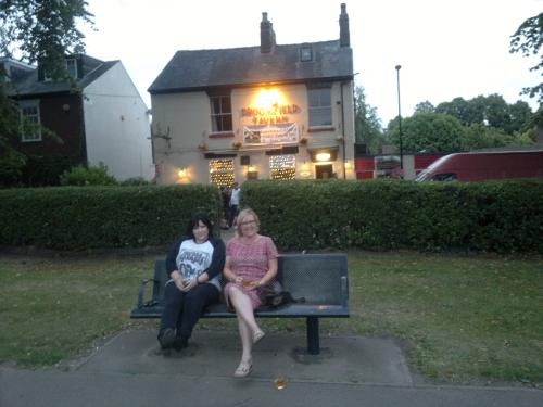
Yes Dreamtime, luckily the 'Broomy' is still there and my girlfriend Julie on the right and her sister are enjoying a nice half pint of pale ale from a real ale pub in this pik
BTW we did take the glasses back to the bar as is was packed on Saturday night so had nowhere to sit except in the park and obviously there are kids and dogs to think about.
Triumph - 'The Best Motorcycle in the World'.
|
| Memories and Nostalgia - Broomfield Park | |
|
Wearethemods
Aberdeenshire |
11 of 40
Mon 13th Jul 2015 7:10pm
On 13th Jul 2015 1:31pm, sally watson said:
the park was known as THE BLACK PAD, it was my local park until the age of 11, I'm 69 now and have wonderful memories of this park, happy days!
I was born in Kirby Road and always knew it in the 50's as the Butts Park with the 'Black Pad' being the wide path under the Railway Arch down to Broomfield Place |
| Memories and Nostalgia - Broomfield Park | |
|
Dreamtime
Perth Western Australia |
12 of 40
Tue 14th Jul 2015 1:56am
Well that was a treat to see, Hope you enjoyed your 'good drop' and thank you for posting your photo to us. My Dad would have great delight seeing the Broom again, it's been just over 50 years since he pulled his last pint and put the towels up. Cheers to you both.
  |
| Memories and Nostalgia - Broomfield Park | |
|
richardge
Cambridge |
13 of 40
Wed 21st Oct 2015 10:15pm
On 13th Jul 2015 12:27pm, Catshed said: ... I found on a 1923 map that Broomfield Place 'Now' was called Broomfield Terrace 'Back then' and Broomfield Place is now Sovereign row.
I was looking around for information on Sovereign Place and came across this discussion. As far as I can see from old maps, the east-west part of what is now Sovereign Row, up to the railway, was formerly Broomfield Place, while the section to the west of the railway was Broomfield Terrace. This appears the case from certainly 1888 to 1938.
I have never seen a name on an old map for the north-south-ish section of current Sovereign Row (from the corner up to Butts) but my strong suspicion is that this was Sovereign Place. Extending that line south past the rugby ground to the railway, the other side of the bridge it becomes Sovereign Road.
And there is this:
British History gives us:
BUTTS, THE* (Summerlands Butts Lane, 1748- 1749) (fn. 53) may have originated in the 'Somerlesow lane' mentioned in 1423. (fn. 54) The Summerlands Butts were certainly in existence in 1635, (fn. 55) and probably, as 'Somerlesue butts', as early as 1468. (fn. 56) In the 1830s the whole road was called the Butts; in addition, houses built on either side of the road at its NW. end formed Sovereign Place and Summer Land Place, those on either side of the opening of Union Street formed Union Place, and the stretch of road between the two ends of Hertford Place* was known as Hertford Terrace. (fn. 57) The eastern end of the Butts was called Queen's Road* by 1887. (fn. 58)
Hope this is of interest. |
| Memories and Nostalgia - Broomfield Park | |
|
dutchman
Spon End |
14 of 40
Wed 21st Oct 2015 11:27pm
Sovereign Place was the name given to the long row of buildings on the south side of the Butts Road between Sovereign Row and the Technical College.
|
| Memories and Nostalgia - Broomfield Park | |
|
dutchman
Spon End |
15 of 40
Sat 24th Oct 2015 12:25am
I'm wrong! According to Spennell's directory Sovereign Place is just the five buildings lining the footpath opposite the Summerland Tavern which I've marked in red here:
 |
| Memories and Nostalgia - Broomfield Park | |

Website & counter by Rob Orland © 2026
