


|
Norman Conquest
Allesley |
1 of 92
Fri 30th Jan 2015 11:59am
Thought this may be of interest. It is in the book "Bloody Coventry" by David McGrory that covers some of Coventry's less pleasant incidents.
Just old and knackered
|
| Local History and Heritage - Coventry Castle | |
|
morgana
the secret garden |
2 of 92
Fri 30th Jan 2015 12:23pm
So Ranulf Blondeville was Welsh Earl of Chester if I'm right.
 |
| Local History and Heritage - Coventry Castle | |
|
flapdoodle
Coventry |
3 of 92
Fri 30th Jan 2015 6:28pm
The Earls of Chester were descendants of the Normans who invaded England and Wales.
|
| Local History and Heritage - Coventry Castle | |
|
Midland Red
|
4 of 92
Sun 7th May 2017 8:13am
|
| Local History and Heritage - Coventry Castle | |
|
AD
Allesley Park |
5 of 92
Fri 12th May 2017 1:40pm
I've got a bit of an issue with the description of "chapel of St Michael in the Bailey, later to become the old cathedral"
If the same structure were to become the old cathedral then either the ditch around the bailey is in the wrong place and needs to be further north for it to be within the bailey or, more likely, the chapel mentioned is a completely different structure and in a slightly different place to that which we know as the old cathedral.
|
| Local History and Heritage - Coventry Castle | |
|
Annewiggy
Tamworth |
6 of 92
Fri 12th May 2017 2:32pm
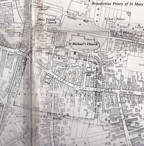
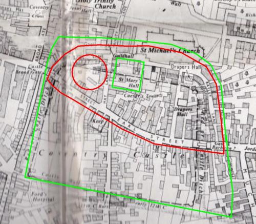
This map circa 1750 shows the position of the castle and ditches. AD I think you are correct in saying that the original St Michael's was probably in a different place inside the castle.
 |
| Local History and Heritage - Coventry Castle | |
|
Rob Orland
Historic Coventry |
7 of 92
Fri 12th May 2017 3:27pm
On 12th May 2017 1:40pm, AD said:
I've got a bit of an issue with the description of "chapel of St Michael in the Bailey, later to become the old cathedral"
If the same structure were to become the old cathedral then either the ditch around the bailey is in the wrong place and needs to be further north for it to be within the bailey or, more likely, the chapel mentioned is a completely different structure and in a slightly different place to that which we know as the old cathedral.
I can see where you're coming from AD, and on first read-through it does sound that way. I assume that you're taking the routing of the ditch from my short piece about the castle on this history page ? If you read it all, you'll notice my line: "At some point, the ditch was re-routed to run past the north edge of what later was to become the huge tower of St. Michael's".
The significance of this is that the early chapel must've been started after the ditch was re-dug slightly farther north (probably only 20 yards or so, if indeed Bailey Lane runs along the line of the earlier ditch). So, with a new "farther out" ditch, a very small chapel was built within the castle grounds, only just inside the northern boundary. The current South Porch of the Old Cathedral is the only remaining part of that earlier church, and my guess is that the porch would've formed a small south transept.
Then, two centuries later, long after the castle had fallen into disrepair and the ditch filled in (and probably forgotten about), the church was massively expanded over the ground where the ditch had once run (it couldn't be extended southwards because the Guildhall was there by then), meaning that the looser soil of the filled in trench ran straight under St. Michael's from the north side of the tower to the apse at the east end. Even before the church's tower was completed, the builders obviously noticed it was on dodgy ground and leaning slightly, as one of the stone courses is tapered in order that the rest of the tower continued upright!
At the start of the church's expansion, however, the tower would've stood centrally along the original west end - but by the time the later expansion took place, including the building of the apse, it had obviously grown larger than they'd planned for a century earlier, so the apse, being central to the western end, did not line up with the tower. This is almost certainly the reason why the line of pillars had to swing northwards slightly, to join up with the south side of the apse. If you stand in the ruins today (or tomorrow!), it will appear that the current northern arcade of pillars (or stubs nowadays) could originally have been where the north wall stood of the half-expanded church of the early to mid 1300s. |
| Local History and Heritage - Coventry Castle | |
|
AD
Allesley Park |
8 of 92
Fri 12th May 2017 3:33pm
Thank you for that Anne - I've never seen a map indicating the probable position of the keep, though I guess it kind of becomes obvious when you look at the routes entering the castle.
Also interesting is Caesar's Tower - if that was once part of an entrance to the castle there must have been another road between Hay Lane and St Mary St? Although I think it more likely it wasn't part of an entrance at all.
|
| Local History and Heritage - Coventry Castle | |
|
Annewiggy
Tamworth |
9 of 92
Fri 12th May 2017 3:44pm
Caesar's Tower seems to be described as a fortified town house.
|
| Local History and Heritage - Coventry Castle | |
|
AD
Allesley Park |
10 of 92
Fri 12th May 2017 4:15pm
Hi Rob
Yes I have used your site to largely position everything (though I've always used Bayley Lane as being a rather obvious marker!) but I have always noted that your map show the dotted later wall which does encompass the old cathedral, so I understand what you're saying and you're reasoning on why the old cathedral isn't exactly in line etc.
If I can try and simplify it for myself what we're saying is there are two phases to the castle - Phase I being wooden and Phase II being stone. The first chapel (first mentioned c.1138 according to your excellent site) would've been outside the castle during Phase I and then when Phase II was done in 1162 the wall was rerouted to bring it inside? Then when the chapel was rebuilt in C14 as we know it today it was on the same site of the original but also extended beyond it?
However in your post you say that "the early chapel must've been started after the ditch was re-dug slightly farther north" which would mean it would have to be post 1162 but there is mention of it in 1138?
|
| Local History and Heritage - Coventry Castle | |
|
Rob Orland
Historic Coventry |
11 of 92
Sat 13th May 2017 12:00am
Hi AD,
Thank you for the kindly remark. It appears to me quite likely that you have more knowledge about the castle and the ditch than I do (not difficult, some might say!), and your reasoning seems sound. I didn't know the date of phase II, so if, as you say, the re-routing was 1162, then if an earlier chapel was within the bailey it might indeed have been a different structure in a different position to the current church.
What I'm uncertain about, though, is the date at which the church was referred to as "St. Michael in the bailey". It could be that this reference was made after 1162, in which case the present structure might still be in it's initial location. If this is the case, then I wonder if the church originated outside the bailey, and then later the castle grounds were enlarged, encompassing the chapel? Does that sound feasible to you?
Back to the castle itself though, particularly the possible connection with Caesar's Tower on the back of the Guildhall, I'll copy here a section of David McGrory's "A History of Coventry", which discusses this....
It was not unknown for medieval buildings to have square stone towers. Caesar's Tower is, however, different; apart from the fact that it appears to pre-date the medieval building it is attached to, it is wedge-shaped, not square. It was also originally four storied with battlements; these battlements were already ruinous in 1471 when they were repaired. So we originally had a tower nearly fifty foot high with battlements and bow apertures. This was facing towards the ditch and exactly in line with the top of Broadgate, the site of the portam. If we mirror this wedge-shaped tower we create a funnel entrance, a killing zone; incidentally during the 1900 excavation two skeletons were found within this killing zone.
The tower has the lower part of a wall possibly part of the original curtain wall running underneath the Prince's Chamber, everything above is later infill. This wall appears to have lost half of its original thickness. Assuming this was the line of the curtain, which, by the way, mirrors the line of the ditch in Hay Lane, its position would show some relevance to the door arrangement in the tower. The tower doors are exactly where one would expect them to be on a castle tower. The first at the base of the curtain, the second, left of it originally approached by an exterior stair and the third in line with the curtain wall. This third door is very important for it is very low and was recorded as being so in the 14th century. This is a defensive doorway made low, for if the battlements are breeched anyone entering this room would have to bend down putting them at a disadvantage and making them vulnerable. The fourth story would be entered from the third floor through an opening in the ceiling.
There was, up until the late 19th century, remains of a massive wall still attached to the kitchens of the hall, behind Caeser's Tower. This was of uncertain date, and by its size, being at least 6 feet thick suggest some connection to the castle site. During renovation work in 1914 on the south-east corner of the kitchen, due to a large crack the foundations were exposed with the intention to underpin it. Underneath was 'revealed an enormous mass of masonry'; workmen tried to find the bottom of this masonry and gave up at 12 feet. Considering that the kitchen is supposed to be one of the oldest parts of the building, does it conceal remains of the castle or did the builders use castle stone simply for its foundations. Lastly, in the undercroft of the hall are two wells, these could of course have originally supplied the castle. More stonework to this building is mentioned by the excellent Victorian historian T.W. Whitley, who stated in 1884 that somewhere around Bayley Lane was unearthed 'a large stone wall of great strength... with much fallen stone around it.' He also noted that this wall followed the line of an intricate circular boundary stretching from Bayley Lane to Broadgate. Some buildings along this boundary were marked with the letter T for Trinity parish. This self-contained circular boundary Whitley believed may have been the boundary of the castle and he noted that it left the castle area heading down to the Sherbourne. This is of course as it was also described on the forged boundary charter of Hugh Keviloc. The point where this boundary passed into Broadgate was at number 18, near top of Broadgate where the castle entrance is believed to have been.
Additionally, it's interesting to note the holes in this Library image showing Caesar's Tower - which look like they could be where "joists", for want of a better description, might have joined this tower to a mirror-image tower - some kind of walkway maybe? Damn the Luftwaffe for depriving us of the original tower! |
| Local History and Heritage - Coventry Castle | |
|
AD
Allesley Park |
12 of 92
Sat 13th May 2017 2:00pm
Hi again Rob
You're giving me far more credit than I deserve - you undoubtedly know a great deal more than I do! I really know next to nothing about the castle other than the info on your site, the 'History of Coventry' book you mention above and the snippet posted above.
The reason I gave those dates (and why I questioned if the church was on the same site) was the snippet at the top stating "Kevelioc received his inheritance.... in 1162, and rebuilt the castle in stone". Now obviously this would have been a significant undertaking and taken some time (probably years) but must have been completed or near completed by 1173 because it states "In 1173.... Kevelioc joined a rebellion against Henry II (who) sent a force to besiege Coventry Castle". So if these statements are correct this rebuild must have occured between 1162 and 1173.
The date of 1138 for the existence of the church I got from your site - Old cathedral.
So going by that the church must have existed before the rebuild and so at some point been outside the castle walls. For me the most likely explanation for the re-routing of the wall is specifically to encompass the church, especially as at the time they were used as places of sanctuary and being inside the castle wall would add to this protection. This is of course purely hypothesis.
Like you, I also wonder when it was referred to as St Michael in the Bailey as this would be very useful for the timeline.
I read the part about Caesar's Tower with interest. From that I get a feeling it would either be part of the curtain wall or more likely given the height the keep?
|
| Local History and Heritage - Coventry Castle | |
|
Rob Orland
Historic Coventry |
13 of 92
Sat 13th May 2017 5:19pm
I'm certainly no expert on this AD, just a bit of an enthusiast perhaps, like yourself by the sound of it. I'm always willing to learn from others or from what I get to read, like Dave's book, etc. My main problem is remembering the stuff - I have over 200 books about Coventry (you might've seen my bibliography on the main site) - but I wonder if I can remember even 1% of what I read!!!
I can now see that your information was also from the same book I mentioned above - I'd just completely forgotten it was all in there! I guess it's a matter of putting all the pieces together into some sort of timeline and working it out - except that certain key bits might not be available, like the date that St. Michael's was described as being "in the bailey". Next time I pop into the Guildhall for a chat with Dave though, I'll try to remember to ask him about it. Perhaps the date was known but not thought to be relevant enough to warrant recording in the book? Always something more to learn, eh!
|
| Local History and Heritage - Coventry Castle | |
|
Helen F
Warrington |
14 of 92
Sat 13th May 2017 6:53pm
The castle or castles are a real mystery to me. Which is why when someone said that they were doing an early reconstruction of the city I thought 'good luck'. There are many snippets of information but nothing concrete. There's talk of it going through a bake house off Hay Lane and a tower found off Derby Lane and that a ditch ran under part of St Michael's tower. My thoughts are that we don't know how many inner baileys the castle might have had so any wall might be an inner or outer defence. Ditto ditches, plus there were defences that pre-dated even the castle/s.
Bayley Lane and the High Street + Earl Street form a classic motte and bailey shape. Putting the motte at the top of the hill, west of Hay Lane. First question, did the road run round the outside or the inside of the palisade or not exist at all? It seems likely that early buildings would butt up against the wooden wall. So was the early ditch later turned into the roadways? Or were the buildings on the outer edge of the boundary roads up against the wall? One thing has occurred to me is that the run of very old cellars on Earl Street and the High Street may have been sunk into an existing hole in the ground ie the early ditch.
When the stone wall was built, it seems to me that they might have left the palisade in place and built the new defences on a larger loop, to still have the protection of the old defences at all times. Might they have done the same with the motte? Moving the new keep sideways to somewhere nearer Caesar's Tower? The old side might then have been flattened for other buildings.
Another thing that occurred to me was the old prison might have been part of the old castle complex. Taking a loop round that, just clipping the edge of St Michael's tower (as would be) and round the north edge of the earliest form of the church (just to the east of the tower and about as wide N/S). Then curving round a loop beyond the buildings on the east of Bayley Lane. Might the Herbert cellar be on the line of the ditch? The south line probably ran as per Anne's map.
The west line is more difficult. My theory is that Grey Friars Lane, Broadgate and Butcher Row were originally in line with each other and that the front row of buildings on Broadgate were 'new'. That would have had the Broad Gate opening directly onto Broadgate the street and not with a little bit of High Street first.
Just my wild guesses.
 |
| Local History and Heritage - Coventry Castle | |
|
Rob Orland
Historic Coventry |
15 of 92
Sun 14th May 2017 11:21am
Some super observations there Helen! And an interesting thought that later cellars might've been built into the softer soil of earlier ditches.
Yes, I think "good luck" to all of us who might try to decipher the fragmented and few documents or images that are available. And so frustrating that so much of our history is still there beneath our feet, but most will not be revealed in our own lifetimes while currently used buildings occupy the locations.
Anne's map is interesting too, but also begs so many questions. It's a strange combination of a modern-day take on where medieval items might've stood upon an early 1900s map! And the keep.... how did that get marked there, and by whom? I've never heard any speculation as to it's location, so I wonder who marked up this map with such features, and what did they know? Oh, so many questions....
|
| Local History and Heritage - Coventry Castle | |

Website & counter by Rob Orland © 2026
