Helen F
Warrington
|
46 of 128
Mon 24th Sep 2018 7:18pm
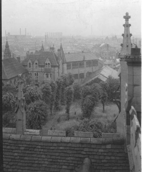
The photographers were stood on Priory Row looking north west over what had been the graveyard towards the school. The tower of the school being the north West tower to St Mary's. The floor of St Mary's was always below the ground level on the south side. The archaeologists found two doorway openings (1m from the floor of the building) with the remains of steps on the inside of the cathedral. A bit odd I'll admit. One of the doorways had been blocked up in ancient times and the other probably had a porch.
Priory Row itself is higher than that but I don't know by how much (guess 1.5- 2m). When in use, Priory Row might have been lower by 0.5-1m but was probably never at the same height as as the cathedral. Below is a similar view but taken from the roof of Holy Trinity in 1930. I'll try and write a potted history of the cathedral to explain why the design doesn't seem logical.

|
|
Streets and Roads -
Priory Row
|
Kaga simpson
Peacehaven, East Sussex
|
47 of 128
Tue 25th Sep 2018 4:58pm
Helen,
Thank you, exactly where I thought, but the diagram on post 35 puts the cloister and buildings on the south side of the Cathedral in Bayley Lane, that confused me. |
|
Streets and Roads -
Priory Row
|
Helen F
Warrington
|
48 of 128
Tue 25th Sep 2018 5:50pm
You're both right. The diagram has north at the top. It's New Buildings (stupid name) curving round, not Bayley Lane. The cloister is flush against St Mary's (cathedral) to the north. Too many names repeat. It's very confusing. |
|
Streets and Roads -
Priory Row
|
Kaga simpson
Peacehaven, East Sussex
|
49 of 128
Tue 25th Sep 2018 6:30pm
To me,
St Mary's Priory, built on the side of a hill, the river down below, surrounded by woodland, it would have been a wonderful view, drifts of wild primroses, bluebells, and lent lilies under the trees, so the division between the the priory and its surrounding woodland were softened. Soft ribbons of mist laying over the river. Around Coventry there were many fords, so the wild landscape was not unlike Turner's paintings.
As early as the 13th century the priory of St Mary's had a market in the town for cheeses, against the chief-gate of the castle of the Earls of Chester in Cross Cheaping and other markets for cattle and pigs and possibly wool, etc.
As a kid I loved the fields and woods, but entranced by the city too, the churches and historical landmarks of Coventry and the teeming human life.
At 7 years of age I was a 'Cub' and expected to do a good deed every day, so when I saw an old lady struggling up Priory Row with a shopping basket I rushed to help. "Thank you" she said as we reached the top of the hill. "I can manage now". On the way down I trespassed by peeping through un-shuttered an un-curtained window, and pretended I could not hear mother shouting for me from Butcher Row. The house, stood empty, was perfect for my purpose as I pressed my nose against the pane. I could see the size of the rooms and some of its contents but would dearly would have liked to have explored the whole house. At that time Priory Row was more overgrown and very dowdy and not pleasant to walk through. |
|
Streets and Roads -
Priory Row
|
Prof
Gloucester
|
50 of 128
Tue 25th Sep 2018 6:32pm
|
|
Streets and Roads -
Priory Row
|
Kaga simpson
Peacehaven, East Sussex
|
51 of 128
Wed 26th Sep 2018 8:53am
Helen
Stan's diagram says St Michael's then on the right Holy Trinity so that can only mean the south side was Bayley Lane, and that does not fit in with your photos. It's a long way round to the other side of Priory Row and your photos? |
|
Streets and Roads -
Priory Row
|
Helen F
Warrington
|
52 of 128
Wed 26th Sep 2018 10:20am
Are you using one of those devices that rotates stuff depending how you hold it? I see Holy Trinity on the bottom to the left and The new St Michael's running up the right.The old one is off the bottom of the picture to the right. The new one is at right angles to the old ones, running north-south, cutting through Priory Row and running parallel to Hill Top. All the others in this group run roughly east-west. |
|
Streets and Roads -
Priory Row
|
Kaga simpson
Peacehaven, East Sussex
|
53 of 128
Thu 27th Sep 2018 9:28am
Helen,
You have lost me again, what new St Michael's? Can't find any mention on this forum of a S to N church, have I missed something? I'm sure no one has heard of that one, what history book is that in? As far as my books say there was always the parish churches there, I believe before St Mary's.
No, what I am querying is Stan's diagram. If we twist it around then it puts the Trinity church south of St Michael's and the Guildhall half-way down Trinity Street.
But if we take Stan's diagram as it stands and twist the Priory photo to the top left hand corner then you have the diagram right, Bayley Lane right and the Guildhall right.
If we leave the Priory as you say, half-way down Trinity Street in the north, then how does it fit in with the Guildhall in the south? It was my impression that the Guildhall dignitaries always kept close to the church, to me that would be the south entrance in Bayley Lane. Just a query on the history of the Priory. |
|
Streets and Roads -
Priory Row
|
Helen F
Warrington
|
54 of 128
Thu 27th Sep 2018 10:01am

Sorry, I thought we were talking about this diagram? The building running north south on the right is the new St Michael's cathedral built after the war. St Mary's cathedral ruins run east-west in the middle, as does Holy Trinity bottom left. I include a rough idea of the outline of St Mary's on the aerial view. Does this help?
 |
|
Streets and Roads -
Priory Row
|
Kaga simpson
Peacehaven, East Sussex
|
55 of 128
Thu 27th Sep 2018 10:49am
Thanks Helen for your swift reply, yes it's the same diagram. I didn't see anything like that or mentioned in the fifties when they were building the new Cathedral. Guess I'm way out of touch, so thanks again, regards Kaga. |
|
Streets and Roads -
Priory Row
|
Helen F
Warrington
|
56 of 128
Thu 27th Sep 2018 11:43am
There were a lot of suggestions for the new cathedral and some of them respected the original orientation. If you never saw it finished it would be hard to imagine the finished building. Personally I don't like it at all. You also haven't been back to see the excavations so it's hard to orientate it all. I certainly couldn't work out where the different digs took place in relation to the school tower until I started plotting them on the old maps. It's not straightforward to look at those maps and see the current landscape at all. I still haven't finished matching all the photos of ruins to the map.
The city is very confusing. Which is why it's taken me this long (over 5 years now  ) to picture what you remember. |
|
Streets and Roads -
Priory Row
|
Prof
Gloucester
|
57 of 128
Fri 19th Oct 2018 7:40pm
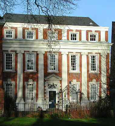
One of Coventry's Georgian gems
 |
|
Streets and Roads -
Priory Row
|
heathite
Coventry
|
58 of 128
Mon 29th Oct 2018 4:21pm
On 16th Sep 2018 11:37pm, Osmiroid said:
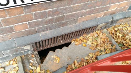
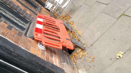
Is anyone else sick of this eyesore blocking the Priory Row sign?
Looks like an item that would belong to the council.

I don't know if the guard is still there but this shows why it was.


|
|
Streets and Roads -
Priory Row
|
Osmiroid
UK
|
59 of 128
Tue 30th Oct 2018 1:17am
Yes, I knew it was something like that. Way over the top though, that big barrier. They could have used something like a railway sleeper or a paving slab as something solid but temporary.
|
|
Streets and Roads -
Priory Row
|
Annewiggy
Tamworth
|
60 of 128
Tue 30th Oct 2018 9:09am
Or even repair it Osmiroid, but I suppose they have got to have a meeting to decide whose job it is! |
|
Streets and Roads -
Priory Row
|
