|
Helen F
Warrington |
31 of 128
Wed 19th Sep 2018 4:39pm
Anne, I know what you're referring to and I have a couple of images of the cellar. I've not tried to work out where the wine merchants was yet. I've got loads of images with bits of the priory and maps of excavations. I hope to match all the images with the archaeology. All the ancillary buildings were to the north, towards the river and some were built onto crypts to bring them to the level of the cathedral floor (ish). The kitchen was the most northerly and seems to have been at the ground level of New Buildings and probably at the level of the crypts floors. A lot of the modern archaeology has exposed what was left of the crypts and the stone debris that levelled things off after the cathedral was demolished. |
| Streets and Roads - Priory Row | |
|
Kaga simpson
Peacehaven, East Sussex |
32 of 128
Wed 19th Sep 2018 5:28pm
Helen F, that's fantastic, did you get those from some book? I would never have thought of float but I can see what Rob was thinking of now, I do apologise Rob. |
| Streets and Roads - Priory Row | |
|
Helen F
Warrington |
33 of 128
Wed 19th Sep 2018 6:39pm
I got the images from the internet Kaga. It's hard to relate the modern photos with the old. Even harder to understand the timelines.
I don't know what the soil level was in your day Kaga but since the cathedral's heyday the area had filled with plant debris, animal droppings, stones and stone dust. In the late 1700s and 1800s the area was used as a graveyard for about 2500 people with attendant headstones and 37 brick lined vaults. They too became partly buried in soil and we got to this image -
Trinity graveyard |
| Streets and Roads - Priory Row | |
|
Rob Orland
Historic Coventry |
34 of 128
Wed 19th Sep 2018 9:01pm
On 19th Sep 2018 5:28pm, Kaga simpson said:
Helen.F that's fantastic, did you get those from some book, I would never have thought of float but I can see what Rob was thinking of now, I do apologise Rob.
Hey, no problem at all Kaga, we're all learning all the time, it never stops. And I have to say, Helen seems to have learned more about our city in the last two years than I have in two decades! |
| Streets and Roads - Priory Row | |
|
Rob Orland
Historic Coventry |
35 of 128
Wed 19th Sep 2018 9:08pm
On 19th Sep 2018 6:39pm, Helen F said:
I don't know what the soil level was in your day Kaga but since the cathedral's heyday the area had filled with plant debris, animal droppings, stones and stone dust. In the late 1700s and 1800s the area was used as a graveyard for about 2500 people with attendant headstones and 37 brick lined vaults....
Do any of the images in these views of Blue Coat School help at all, regarding the ground level? |
| Streets and Roads - Priory Row | |
|
Helen F
Warrington |
36 of 128
Thu 20th Sep 2018 12:38pm
Thanks Rob but the key phrase is 'Helen seems' 
|
| Streets and Roads - Priory Row | |
|
Annewiggy
Tamworth |
37 of 128
Thu 20th Sep 2018 1:41pm
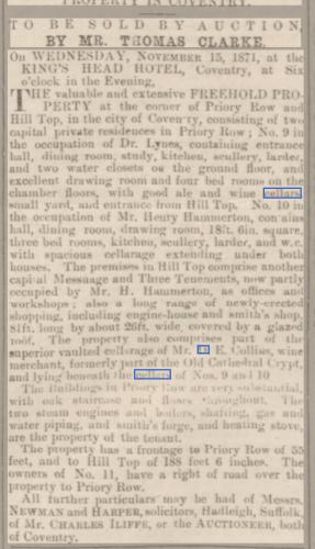
1871

|
| Streets and Roads - Priory Row | |
|
heathite
Coventry |
38 of 128
Thu 20th Sep 2018 3:02pm
Excellent, quite a find. |
| Streets and Roads - Priory Row | |
|
Helen F
Warrington |
39 of 128
Thu 20th Sep 2018 3:21pm
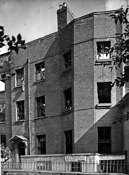
I agree with Heathite, a good little clipping. The building on the corner of Hilltop would have partly sat on the main east west wall but also part of the south transept. Hill Top wiggled through the archaeology of the priory, avoiding some of the more durable structures like the central tower and the Chapter House. At first it probably went through doorways and down steps before the whole thing was turned into an outdoor sloping road. In consequence any buildings to the sides of Hill Top were built on parts of the priory, converting them into cellars or foundations. |
| Streets and Roads - Priory Row | |
|
Annewiggy
Tamworth |
40 of 128
Thu 20th Sep 2018 3:40pm
Thanks for the picture Helen, I have not seen that building before. You can see the top of a basement at the bottom of the building. Yes, I often think I have a picture of something someone asks about but can't remember where I saw it.
Levi Fox mentions the cottages in his Coventry's Heritage book.
Half Timbered cottages, Priory Row. Little is known about the history of this group of half timbered buildings. Built about the middle of the sixteenth century, it has been stated that the three cottages (Nos. 3, 4 and 5 Priory Row) were originally one house called Lych Gate House, erected by John Bryan, vicar of Holy Trinity. They have a long connection with this church and its verger still lives in one of them (1947). The modern half-timbered store adjoining replaced an ancient corner house and shop. When the latter was demolished, two medieval doorway recesses were discovered in the basement wall under the west end of no. 3 Priory Row ; these doubtless formed part of the original monastic buildings which covered the site.
I also came across this plan in Stan's papers that may be interesting. it appears to have contour lines on it.

|
| Streets and Roads - Priory Row | |
|
heathite
Coventry |
41 of 128
Thu 20th Sep 2018 4:30pm
That is a good diagram/map.
Thank you. |
| Streets and Roads - Priory Row | |
|
Kaga simpson
Peacehaven, East Sussex |
42 of 128
Thu 20th Sep 2018 6:26pm
Rob, Helen,
Helen's pictures are great, but to me the priory is on level ground and so is the walkway, the sunken part is today's lawn. Most priories had a sunken cloister to catch the sun, it was a meditation and healing garden, the doors to the house were on the same level as the walkway and, I would think, Priory Row, but all these mediaeval places were added to or taken away throughout the centuries. Helen do you agree? |
| Streets and Roads - Priory Row | |
|
Helen F
Warrington |
43 of 128
Thu 20th Sep 2018 7:34pm
I can visualise what you're thinking Kaga and I'd have done it that way too, with an under croft beneath the main area, making the floor level with Priory Row. Only they didn't. The archaeologists found floor tiles at a bit below the grass level. The landscaping is there in part to protect what they found. They also discovered the remains of a big curving set of steps leading down from the far end where the door would have been. You're right that the churches used to be built on the flat and the speculation as to why they didn't build St Mary's further up the hill, towards where Holy Trinity stands, is because the original nunnery was there. Or maybe they wanted to be closer to the river? Or maybe they weren't given that bit? Whatever the reason they built half way up the hill. I'm sure I read somewhere that they had problems of rain water runoff getting into the south side (nearest Priory Row). However, it did mean that the cathedral floor was at a closer level to the cloister and many of the main priory rooms, some of which were built on under crofts to bring them up to the cloister level.
Another though occurs. Priory Row itself may not be at its original height. The surface level is about a foot higher than when it was captured in some of the sketches I've got. Maybe it was even lower 800 years earlier? Soil has been shifted about since before the Norman castle was built. Who knows what the raw landscape looked like. |
| Streets and Roads - Priory Row | |
|
Kaga simpson
Peacehaven, East Sussex |
44 of 128
Sat 22nd Sep 2018 11:03am
Rob,
Seems everyone agrees with you, but I have a few doubts. If Priory Row and the churches were built ten feet lower at street level, then the doors would have been 15-20 foot high and every so often would have to have a chunk cut off the bottom to fit in with the rising ground. The altar would have been ten feet below the window - the mind boggles.
And the photo of St Mary's - now was the street level where those black doors are, or where the walkway runs? I also feel there were no photos, so everyone is guessing and in that case they do not add up. |
| Streets and Roads - Priory Row | |
|
Kaga simpson
Peacehaven, East Sussex |
45 of 128
Mon 24th Sep 2018 5:31pm
Rob,
The way I read you, you're saying Priory Row was ten feet more or less deeper in the 15th century than in the 1950s.
Yet I thought the guildhouse was built some 600 years ago and that was on the same street level as the council house in the 1950s?
Helen, I haven't been in Coventry for over fifty years. Looking at the photo you posted of St Mary's where would the photographer have been standing, and what way was he looking, north or west, in relation to 1950? |
| Streets and Roads - Priory Row | |
Website & counter by Rob Orland © 2024
Load time: 658ms