
|
paulmartin
coventry |
1 of 23
Mon 13th Sep 2010 3:41pm
Hi everybody, just posting to let you know that Google Earth have added an aerial view of Coventry (as well as other large sections of the country) taken in 1945 to go alongside the existing available images, one done in 1999 and further ones taken throughout the last decade.
To view the historical images in Google Earth you need to click on the clock button in the tab bar at the top and you can then use a slider to select the imagery you want to view.
Cheers,
Paul
|
| Local History and Heritage - Coventry from the air | |
|
dutchman
Spon End |
2 of 23
Tue 14th Sep 2010 12:57am
Many thanks for the headsup Paul.
Among other things the line of the city wall is clearly visible behind the gardens on the south of Godiva Street
The odd collection of circular structures visible on the south side of Gulson Road, between Charterhouse Road and the Sherbourne, is actually a funfair! When the funfair wasn't in town the area was used as a makeshift "beach".
Had Broadgate Island already been laid out by 1945?
It's a pity we can't zoom-in with Street View like we can today. It would be like travelling back in time :o)
|
| Local History and Heritage - Coventry from the air | |
|
Rob Orland
Historic Coventry |
3 of 23
Tue 14th Sep 2010 9:16pm
dutchman said:
Had Broadgate Island already been laid out by 1945?
I have a photo on this page.... https://www.historiccoventry.co.uk/blitz/blitz.php?pg=myths#coventrated which shows the Broadgate area in 1946 with the garden island not yet developed. However, I believe this could be early '46, because I saw someone else's photograph recently (I'll try to obtain a scan within a week or three), which I'm sure said 1946 - and although the island had not been built, the shape of the pavement had been laid out around what was to become Broadgate House, which was, of course, set back into the soon to be demolished Smithford Street. So it seems that work was certainly underway by 1946 (I think !).
I'm now going to install Google Earth to see those aerial views - thank you for the tip off. |
| Local History and Heritage - Coventry from the air | |
|
Rob Orland
Historic Coventry |
4 of 23
Tue 14th Sep 2010 9:45pm
Well I've now looked at that old view on Google Earth, and the dating is definitely not 1945. It is extremely interesting to see such a view, and I commend Google for providing such a wonderful service (for free !), but I would say that the aerial view is probably late 1940s - possibly 1948 if the island is present but with no Godiva statue - although admittedly it's difficult to tell from that image if the statue is present or not.
Another thing.... it looks like the old cathedral has been cleared of rubble, which happened in 1947.
The upper precinct is definitely taking shape, although the west half of Smithford Street is still there - and will remain so until July 1958 when it was cleared for the rest of the lower precinct to be finished.
Thanks also for letting us know about the fun fair - I had no idea about that!
|
| Local History and Heritage - Coventry from the air | |
|
dutchman
Spon End |
5 of 23
Wed 15th Sep 2010 2:43pm
Rob Orland said: Thanks also for letting us know about the fun fair - I had no idea about that! But for the late Larry Broadhurst, who was regular contributor to local forums, I would have had no idea myself! Have to admit to being slightly incredulous when Larry first told me about it as I have only ever known that area to be a tyre fitting garage. It's a really lucky coincidence for me that the fair was in town on the day when the picture was taken. |
| Local History and Heritage - Coventry from the air | |
|
paulmartin
coventry Thread starter
|
6 of 23
Wed 15th Sep 2010 5:09pm
Thanks for the further information, very interesting!
|
| Local History and Heritage - Coventry from the air | |
|
NeilsYard
Coventry |
7 of 23
Sat 25th Sep 2010 10:07am
Agreed really interesting - thanks for letting us know. Wonder how they got that shot?
It's amazing how rural Broad Lane is and is it me or is Baginton airport still disguised?!
Has anyone else noticed in the modern view - if you go down to ground level and click on 3D buildings this now extends to a fair few of Coventry's taller ones now? Pretty amazing stuff.
|
| Local History and Heritage - Coventry from the air | |
|
JuanToTree
Coventry |
8 of 23
Fri 19th Aug 2011 8:59pm
Hi, interesting stuff, but does anyone know what the areas of the 1945 images that have been coloured green are?
There are 2 by Crackley Lane and a further 2 close to Corley. Were there military bases there?
|
| Local History and Heritage - Coventry from the air | |
|
TonyS
Coventry |
9 of 23
Fri 2nd Mar 2012 8:46pm
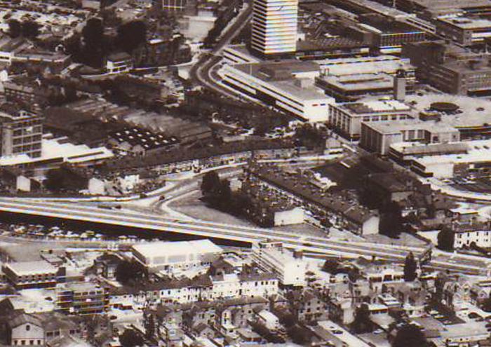
Thanks to Rob, everyone can now share my scan of an Aerial View of Coventry. The original photo was taken in November 1963 and appeared in the Coventry Express newspaper.
Either go via the "Street Maps -> Old Map Scans" buttons or click this link to view.
|
| Local History and Heritage - Coventry from the air | |
|
dutchman
Spon End |
10 of 23
Fri 2nd Mar 2012 10:37pm
Fascinating Tony, thanks
 There are a lot of big buildings there in Hillfields I either don't recognise or don't remember. Also a row of three-storey buildings behind Spon Street I've never seen before!
 |
| Local History and Heritage - Coventry from the air | |
|
Adrian
UK |
11 of 23
Sat 3rd Mar 2012 1:24pm
Brilliant posting Tony, lots of places I had forgotten.
|
| Local History and Heritage - Coventry from the air | |
|
TonyS
Coventry |
12 of 23
Sat 3rd Mar 2012 10:21pm
In 1965, two years after this photo was taken, I worked in the City Arcade (well documented elsewhere on the forum!) and distinctly remember eating at a small cafe which I am sure was situated on the corner of Croft Road and Queen Victoria Road (centre foreground of the scan) where Ikea now stands.
In my scanned photo there is a row of three-storey houses, which would have had to be demolished in that two-year gap and the cafe built in their place. I think this cafe was the first in a row of temporary shops - similar to the ones further along in Corporation Street.
Can anyone verify this, or is my memory playing tricks on me (again!)? Thanks
|
| Local History and Heritage - Coventry from the air | |
|
dutchman
Spon End |
13 of 23
Sat 3rd Mar 2012 10:39pm
On 3rd Mar 2012 10:21pm, TonyS said:
In 1965, two years after this photo was taken, I worked in the City Arcade (well documented elsewhere on the forum!) and distinctly remember eating at a small cafe which I am sure was situated on the corner of Croft Road and Queen Victoria Road (centre foreground of the scan) where Ikea now stands.
I didn't become familiar with the area until 1967 but (possibly wrongly) I remember the first building on that corner as being a rather grubby newsagent's shop.
On 3rd Mar 2012 10:21pm, TonyS said:
In my scanned photo there is a row of three-storey houses, which would have had to be demolished in that two-year gap and the cafe built in their place. I think this cafe was the first in a row of temporary shops - similar to the ones further along in Corporation Street.
As I remember it, that side of Croft Road was left intact when the radial spur was driven through in 1966. It was the houses on the Drill Hall side of the road which were demolished. Although now called 'Croft Road' the radial spur was actually built parallel to the original which survived I think as an access road until the Co-op superstore was built.
I don't remember any temporary shops, at least from 1967 onwards although that doesn't mean there weren't any.
|
| Local History and Heritage - Coventry from the air | |
|
philex31
Devon |
14 of 23
Sun 4th Mar 2012 10:52am
I recall a cafe near the corner of Queen Victoria Road and Croft Road. I only saw it from the bus but it seemed to have an Italian theme and a possibly football-related "Milano" sign in the window. This would have been about 1967-68.
|
| Local History and Heritage - Coventry from the air | |
|
Midland Red
|
15 of 23
Sun 4th Mar 2012 5:15pm
Not sure how clear this is, D
 |
| Local History and Heritage - Coventry from the air | |

Website & counter by Rob Orland © 2026
