

|
scrutiny
coventry |
256 of 264
Wed 9th Feb 2022 12:33pm
I believe the car park is used solely for Covid testing. |
| Streets and Roads - Inner Ring Road | |
|
PeterB
Mount Nod |
257 of 264
Wed 9th Feb 2022 3:16pm
Moat Street car park (under Junction 7) is permanently closed for parking. It is planned to remove the roundabout and link Croft Road to Butts Road. The Ring Road slips roads will be 'T' junctions. This is to encourage walking by getting rid of the subways. |
| Streets and Roads - Inner Ring Road | |
|
Helen F
Warrington |
258 of 264
Wed 9th Feb 2022 4:46pm
That's what I was thinking of Peter  I have to say the underpasses are scary. I have to say the underpasses are scary. |
| Streets and Roads - Inner Ring Road | |
|
Wearethemods
Aberdeenshire |
259 of 264
Thu 10th Feb 2022 10:37am
I used those Croft Road underpasses virtually daily during the late sixties, early seventies, including the subway in front of the Technical College over to the YWCA side. I noticed that when staying at the Premier Inn a few years ago it had been filled in and replaced with a surface 'puffin crossing'. Not so the one splitting Upper & Lower Spon Street, running under the RR which was both dirty and scary! |
| Streets and Roads - Inner Ring Road | |
|
NeilsYard
Coventry Thread starter
|
260 of 264
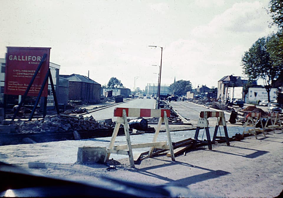
Fri 26th Aug 2022 12:00pm
Here's another great capture, shared with permission from Paul Reynolds on FB, taken again by his dad. I think it's the Foleshill Road junction going in, looking across to the Hill Street gasometer. King Street/Gas Street etc completely disappeared because of this section.
 |
| Streets and Roads - Inner Ring Road | |
|
bk
Coventry |
261 of 264
Wed 19th Oct 2022 11:13am
I added Granville Berry's plan of the ring road to Cov Atlas. I'd be interested to know whether the transparency is correct with some of the roads demolished. I'm as accurate as I can be but there's always room for improvement. b p kyneswood
|
| Streets and Roads - Inner Ring Road | |
|
NeilsYard
Coventry Thread starter
|
262 of 264
Wed 19th Oct 2022 3:29pm
I think it's a little too much to the west, Ben, if you use Hertford Square as an example on the NLS mapping. |
| Streets and Roads - Inner Ring Road | |
|
Helen F
Warrington |
263 of 264
Wed 19th Oct 2022 3:50pm
I find that the NLS is even less accurate. In large part it's due to the less than perfect original maps. Roads are portrayed bigger than life. If you can get most roads and junctions to match real life, you're doing well. |
| Streets and Roads - Inner Ring Road | |
|
NeilsYard
Coventry Thread starter
|
264 of 264
Wed 10th Apr 2024 4:34pm
I think this is King Street going looking across the Upper Well St/Hill Cross Area - you can see the Salvation Army and Gas Showrooms on the right -
|
| Streets and Roads - Inner Ring Road | |

Website & counter by Rob Orland © 2024
Load time: 549ms