
|
PhiliPamInCoventry
Holbrooks |
1 of 10
Wed 7th Apr 2010 11:16am
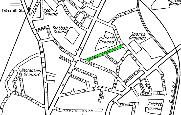
Please, can anyone remember HIGHFIELD STREET. It was located in the Foleshill area, in the region of Station St. There are notes about Highfield Road, but they are not in the correct area.
Thank you
|
| Streets and Roads - Highfield Street | |
|
dutchman
Spon End |
2 of 10
Wed 7th Apr 2010 7:44pm
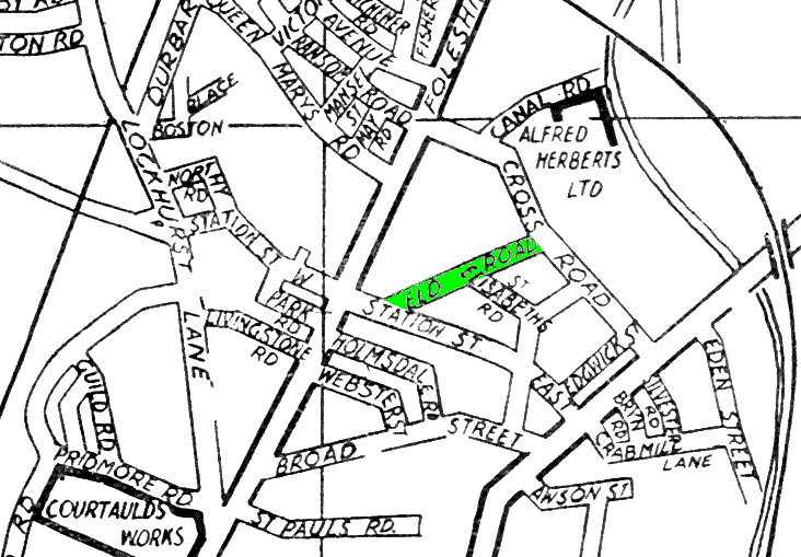
According to Pictures of Coventry it is now called "Eld Road"
|
| Streets and Roads - Highfield Street | |
|
Rob Orland
Historic Coventry |
3 of 10
Wed 7th Apr 2010 9:59pm
According the the "Meaning of Coventry Street Names" book, the name change took place in July 1931. This places my 1932 map as being slightly out of date by still labelling that street as Highfield Street. My 1936 map shows the updated name, Eld Road. Hopefully the two scans below will be of interest.... (looks like nearby Stanley was 'upgraded' to St. Elisabeth, too!)
 |
| Streets and Roads - Highfield Street | |
|
PhiliPamInCoventry
Holbrooks Thread starter
|
4 of 10
Wed 7th Apr 2010 11:21pm
Thank you both so much. This site is a 'gold mine'. I was organist for forty years at a church in Foleshill, where the address of an early twenties' minister was Highfield St.
Best wishes
Philip
|
| Streets and Roads - Highfield Street | |
|
Rob Orland
Historic Coventry |
5 of 10
Thu 8th Apr 2010 8:15pm
It's a pleasure Philip, so glad we could help.
|
| Streets and Roads - Highfield Street | |
|
Mick Strong
Coventry |
6 of 10
Fri 5th Mar 2021 2:54pm
On 7th Apr 2010 9:59pm, Rob Orland said:
According the the "Meaning of Coventry Street Names" book, the name change took place in July 1931. This places my 1932 map as being slightly out of date by still labelling that street as Highfield Street. My 1936 map shows the updated name, Eld Road. Hopefully the two scans below will be of interest.... (looks like nearby Stanley was 'upgraded' to St. Elisabeth, too!)
So was Alfred Herberts built during these 4 years?
Mick Strong
|
| Streets and Roads - Highfield Street | |
|
Rob Orland
Historic Coventry |
7 of 10
Fri 5th Mar 2021 3:27pm
That's a great question Mick. If we get any answers, which I hope we do, we can continue over on the Alfred Herbert thread.
 |
| Streets and Roads - Highfield Street | |
|
Kaga simpson
Peacehaven, East Sussex |
8 of 10
Sat 6th Mar 2021 11:43am
I had a room in a large house on Eld Road in the fifties in the park, but I'm damned if I know what it was called in the thirties. Princess Street should be on those maps of Broad Street.
|
| Streets and Roads - Highfield Street | |
|
Mick Strong
Coventry |
9 of 10
Sat 6th Mar 2021 2:11pm
Kaga, it is there.
Mick Strong
|
| Streets and Roads - Highfield Street | |
|
3Spires
SW Leicestershire |
10 of 10
Sat 6th Mar 2021 3:15pm
In answer to Mick's question:
No, Alfred Herbert at Edgwick precedes the earlier map (1932) by at least 6 years.
Around 1926 the company decided to concentrate production at an extended factory at Edgwick. They transferred plant from the company's main machining facility at the Butts.
|
| Streets and Roads - Highfield Street | |

Website & counter by Rob Orland © 2026
