
|
SHS
Stoneleigh |
1 of 8
Fri 30th Oct 2026 3:04pm
Hello
I am researching two women living at The Cottage in the 1891 census and am trying to establish exactly where the property was located.
The census appears to show two entries for Paradise Place, then The Cottage, followed by another Paradise Place entry, and then Radford Villa and Radford Cottages. This suggests that Paradise Place may have been a small street, court, or cluster of dwellings.
Does anyone know where Paradise Place was situated in 1891, whether it survives today, or if there are any historic maps showing the area? Any information about The Cottage would be especially welcome, as its two occupants were both recorded as laundresses.
Many thanks for any help.
|
| Streets and Roads - Paradise Place, Radford | |
|
NeilsYard
Coventry |
2 of 8
Fri 30th Oct 2026 5:17pm
Welcome to the forum SHS - I've just had a quick look on the 1906 map and can't see any direct mention of a Paradise Place but we do have a thread on Paradise Street..... I'll keep digging.............
|
| Streets and Roads - Paradise Place, Radford | |
|
Helen F
Warrington |
3 of 8
Fri 30th Oct 2026 5:21pm
I don't know of anywhere with all those names in close proximity but short stretches of terraces were often given names, even though they were part of a longer road. Those names often didn't last long. A place called the Cottage was roughly here. I'd have expected the place you were looking for would be off the Radford Road and the Radford Villa was supposed to have been replaced by Villa Road. There's a picture of it if you Google.
|
| Streets and Roads - Paradise Place, Radford | |
|
Rob Orland
Historic Coventry |
4 of 8
Fri 30th Oct 2026 6:45pm
A Google search turned up this surprisingly helpful post on Facebook....
https://www.facebook.com/groups/224800314660611/posts/108129....
...which then led me to looking at the wonderful National Library of Scotland maps....
https://maps.nls.uk/geo/explore/#zoom=17.6&lat=52.42433&lon=....
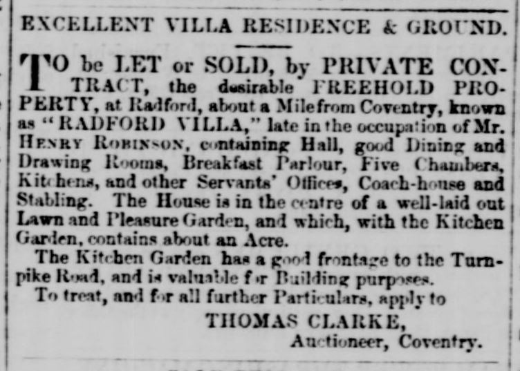
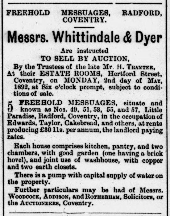
Using the two newspaper adverts I found (below), I would guess that the cottages and villas were part of the cluster just below the congregational chapel shown on the old map (a fader, bottom left, will reveal the modern map), right next to the Radford Road. Possibly where the shops are nowadays on Google Maps.

|
| Streets and Roads - Paradise Place, Radford | |
|
Annewiggy
Tamworth |
5 of 8
Sat 31st Oct 2026 10:49am
I can vaguely remember some old buildings in Villa Road, I think they were top shops in the 1960's but these would have been on the left hand side going up from the Radford Road. They were most probably where the bungalows are now not far up from the shops. On one of the old maps there is a small dead end road marked leading off. These bungalows look newer than the rest of the properties in the road.
|
| Streets and Roads - Paradise Place, Radford | |
|
PhiliPamInCoventry
Holbrooks |
6 of 8
Sun 1st Nov 2026 9:41am
Hello,
That is fascinating. Thank you all.
|
| Streets and Roads - Paradise Place, Radford | |
|
Annewiggy
Tamworth |
7 of 8
Sun 1st Nov 2026 4:58pm
The census mentions Banbury Buildings. I think this was the row of houses opposite the common which were still there when I was younger. Don't forget Beake Avenue would not have been there in the 1800's.
|
| Streets and Roads - Paradise Place, Radford | |
|
SHS
Stoneleigh Thread starter
|
8 of 8
Mon 2nd Nov 2026 7:55pm
Thank you to everyone for your help. Your contributions have helped me identify where in Coventry this was located.
I haven't been able to find an address for Paradise Place in any other census records, so, as Helen suggested, it may only have been known by that name for a relatively short period.
Neil's Yard led me to Paradise Street, but I don't think that's the area I was looking for.
What a fabulous building Radford Villa was.
Thanks again.
|
| Streets and Roads - Paradise Place, Radford | |

Website & counter by Rob Orland © 2026


