


|
NeilsYard
Coventry |
241 of 261
Fri 22nd Mar 2024 11:22am
Actually Robs Pubs Entry states it was from "The Building News" magazine, Jan. 19, 1894.
Rob I think I found the original Pic of that print on FB - can you recall where the info about The Building News came from? A copy of that will be on the 'hunt' list!
|
| Local History and Heritage - City Wall and Gates (inc. Cook Street) | |
|
NeilsYard
Coventry |
242 of 261
Fri 22nd Mar 2024 11:53am
Helen there are online copies of the publication available to view here - sadly the 1894 copy is not included though but a lot to sift through!
|
| Local History and Heritage - City Wall and Gates (inc. Cook Street) | |
|
Helen F
Warrington |
243 of 261
Fri 22nd Mar 2024 12:35pm
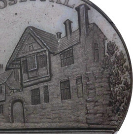
Thanks for that Neil. I have collected a few of the relevant pages of Building News over the years but not this one. There are other pages from 1894 on Ebay but someone else must have snapped up Cook Street. Increasingly old books and magazines are being sliced up to offer individual pages to interested buyers. It's sometimes possible and even cost effective to buy the whole thing, but this is a rarity. Somewhere there might be an oil painting or maybe it has been destroyed. I shall have a look to see if there is anything else I'm missing.
|
| Local History and Heritage - City Wall and Gates (inc. Cook Street) | |
|
Rob Orland
Historic Coventry |
244 of 261
Sat 23rd Mar 2024 10:52am
On 22nd Mar 2024 11:22am, NeilsYard said:
Actually Robs Pubs Entry states it was from "The Building News" magazine, Jan. 19, 1894.
Rob I think I found the original Pic of that print on FB - can you recall where the info about The Building News came from? A copy of that will be on the 'hunt' list!
Ah, I've just searched in my "pub resources" folder, and I'd noted that it was Bill Sutton on Facebook in February 2022 who allowed us to use that fantastic picture from the Building News. It would indeed be great to see the original.
|
| Local History and Heritage - City Wall and Gates (inc. Cook Street) | |
|
Rob Orland
Historic Coventry |
245 of 261
Sun 24th Mar 2024 7:44pm
I've just finished doing a thing.... hopefully a good thing! In place of the hand-drawn (by mouse!) map of the City Wall, which I did around 20 years ago, I've now plotted the wall onto a Google Map, which has hopefully several advantages, among which are:
1. It's zoomable and scalable.
2. It won't go out of date (so long as Google keeps doing its thing).
3. It's far more accurate.
4. If you're "walking the wall" with this map on a 'phone, you can click a "Show my location" button and see your location, so you'll easily find each part of the wall.
I've only just uploaded it, so if anyone spots any flaws or bugs, please let me know.
 https://www.historiccoventry.co.uk/covmaps/wall-in-modern-cov.php
 |
| Local History and Heritage - City Wall and Gates (inc. Cook Street) | |
|
Helen F
Warrington |
246 of 261
Sun 24th Mar 2024 8:26pm
 Very cool, though I dispute the bit at Hill Street. See comment 9 of How old is that building here.. It does away with the need for that odd wiggle before following Bond Street.
You've missed marking in red the surviving bit of wall south of Spon Gate. Very cool, though I dispute the bit at Hill Street. See comment 9 of How old is that building here.. It does away with the need for that odd wiggle before following Bond Street.
You've missed marking in red the surviving bit of wall south of Spon Gate.  Rob tells me that it is a repro and not part of the wall at all. We learn something new every day. Rob tells me that it is a repro and not part of the wall at all. We learn something new every day.
|
| Local History and Heritage - City Wall and Gates (inc. Cook Street) | |
|
NeilsYard
Coventry |
247 of 261
Mon 25th Mar 2024 12:23pm
Nice one Rob! We need to do that Wall Walk now Spring has Sprung!
|
| Local History and Heritage - City Wall and Gates (inc. Cook Street) | |
|
Rob Orland
Historic Coventry |
248 of 261
Mon 25th Mar 2024 6:50pm
On 24th Mar 2024 8:26pm, Helen F said:
Fantastic work, Helen, thank you. I should've taken more notice of that drawing you linked to, but I was so absorbed creating the map! And after further reading in the book "For So Long As the World Shall Endure - The 500 Year History of Bond's and Ford's Almshouses", it does indeed state that the northern wing of the almshouse (the part with the 'wall' embedded into it) was only added in 1816, so before that it would have looked like your image, above. Very cool, though I dispute the bit at Hill Street. See comment 9 of How old is that building here.. It does away with the need for that odd wiggle before following Bond Street.
Anyway, I've now updated / corrected the route of the wall on the Google map, thank you again. |
| Local History and Heritage - City Wall and Gates (inc. Cook Street) | |
| Helen F |
249 of 261
Mon 25th Mar 2024 9:05pm
|
|
Helen F
Warrington |
250 of 261
Sun 21st Apr 2024 10:52am
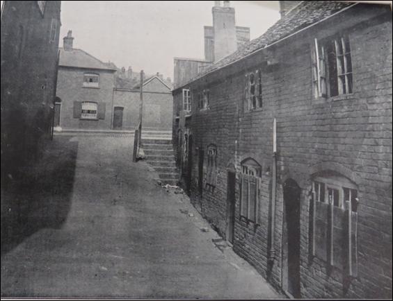
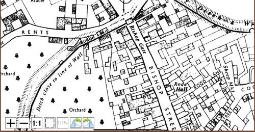
One of the hardest areas of wall to identify is up near the top of Bishop Street. Not only is the true location of the gate unknown but there was a magazine tower, (a tower to store weapons and protective gear) to the east of that. As one of the first areas to be developed outside the city wall, after the Civil War, it has been particularly knocked about. It's not even 100% clear on the Board of Health map. I'm wondering if the curious situation of this row of cottages (below) off Leicester Street might indicate where the ditch was? Was it partially sunk into the ditch (which was only about 7-9ft deep) or was the area next to it built up from wall debris or a bit of both? I can't think of another reason for the stark change in level. Was the front end of the cottages initially free of the built up road? If correct, this would be very useful pinning the wall down at that spot. The BoH map suggests that the wall was under the edge of the buildings on the left, but it's always good to question the map makers' assumptions.
That then begs the question, where was the ditch that fronted the gate and the most logical answer would be under the road and the buildings on the southern edge that fronted it. The road in that area is far closer to where the wall would have been than any other part I can think of, except roads that were built over ditches, after the Civil War, eg Gulson Road. Was the junction of St Nicholas Street, Leicester Street and King Street moved after the ditch was filled in? Or just made much bigger? I've a niggling feeling that I've read that there wasn't a ditch there but I don't see why it wouldn't have had one. Certainly any road would have been much narrower than it was by 1850 and could have fitted north of a ditch if pushed to the most northerly edge of the road we could see before the Ring Road.
 To illustrate the area with a possible location on the ditch.
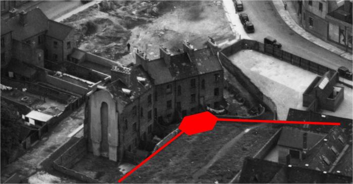
 The photo on the left shows a row of cottages on Leicester Street but there was one more cottage missing, visible in the Troughton sketch. Denoted by the missing doorway with the tiny porch. That sketch also shows a taller building with an archway and the gable of a building that was the end of the cottages shown on the right hand photo.
|
| Local History and Heritage - City Wall and Gates (inc. Cook Street) | |
|
Annewiggy
Tamworth |
251 of 261
Sun 21st Apr 2024 3:46pm
This is a section of the 1750 map on Rob's old map scans and I have read in a newspaper article that the ditch was outside the wall. Don't know if this is any help.
 |
| Local History and Heritage - City Wall and Gates (inc. Cook Street) | |
|
Helen F
Warrington |
252 of 261
Sun 21st Apr 2024 4:37pm
Some, thanks Anne.
 I may be mixing up the areas where the ditch wasn't floodable.
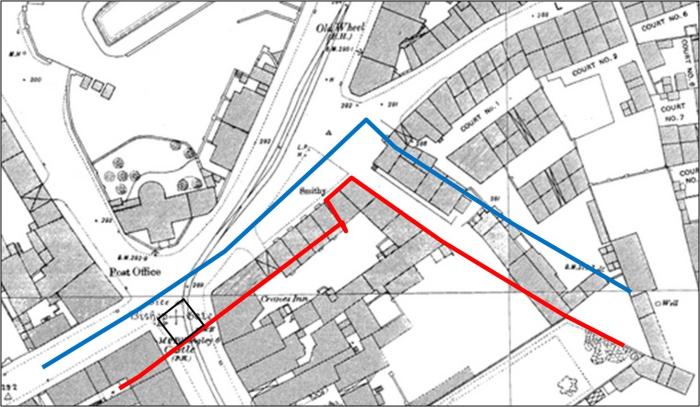
That map was a merger of the Bradford Map with the late 1800s maps. Logic says that the wall went through the Cranes Inn, but exactly where, isn't obvious. Similarly the wall cut through the Castle Inn on the other side. It was not uncommon for the ruins of previous structures to be used as the foundations of the next construction and ditches to serve as the start of cellars. It shows King Street/New Rents as very narrow if there was a ditch. Either the road needs to move north or the wall south at that point. Unfortunately most excavations have been on areas of the wall that weren't a total mystery. I may be mixing up the areas where the ditch wasn't floodable.
That map was a merger of the Bradford Map with the late 1800s maps. Logic says that the wall went through the Cranes Inn, but exactly where, isn't obvious. Similarly the wall cut through the Castle Inn on the other side. It was not uncommon for the ruins of previous structures to be used as the foundations of the next construction and ditches to serve as the start of cellars. It shows King Street/New Rents as very narrow if there was a ditch. Either the road needs to move north or the wall south at that point. Unfortunately most excavations have been on areas of the wall that weren't a total mystery. |
| Local History and Heritage - City Wall and Gates (inc. Cook Street) | |
|
Helen F
Warrington |
253 of 261
Sun 28th Jul 2024 1:14am
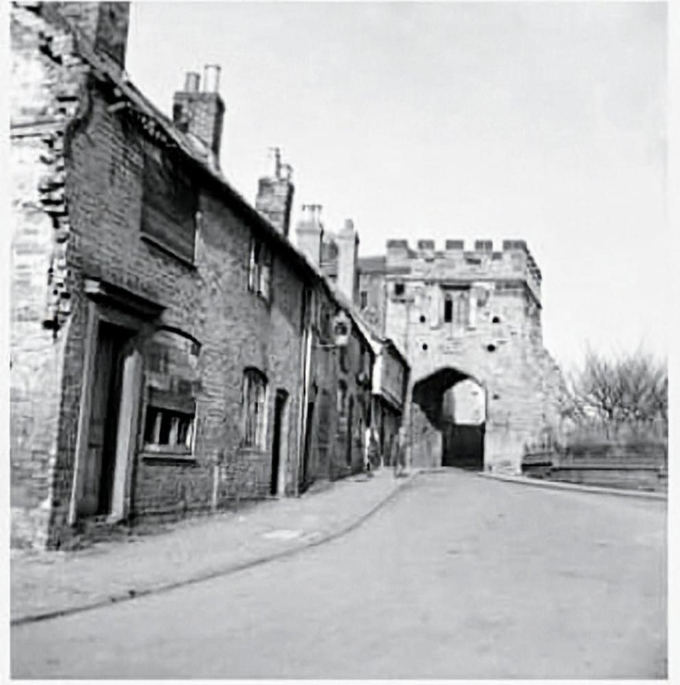
As part of the preparations for the civil war they built a new tower just south of New Gate. By 1850 much of the wall had gone but in places it still acted as a retaining wall and one such area was north and west of the tower. There was a distinct change in level from one side of the wall to the other because the outside was part of the ditch that protected the city. Into that ditch was built Brookville Terrace, with the first 4 built before 1850 (starting on the right with number 1 missing after the bombing). At number 3 the tower would have sat flush with the garden wall. The properties would probably have suffered from damp or even flooding, due to the soggy conditions at the bottom of the ditch.
|
| Local History and Heritage - City Wall and Gates (inc. Cook Street) | |
| Wearethemods |
254 of 261
Sun 28th Jul 2024 9:56am
|
|
NeilsYard
Coventry |
255 of 261
Wed 28th Aug 2024 2:40pm
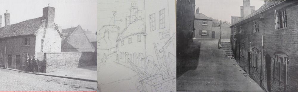
This one is nice as its taken a bit further down to show more of that old row -
 Compare nicely with this one -
|
| Local History and Heritage - City Wall and Gates (inc. Cook Street) | |

This is your first visit to my website today, thank you!
5,210,896Website & counter by Rob Orland © 2025
Load time: 600ms