Throwley
Bucks
|
151 of 177
Thu 12th Sep 2024 9:18am
On 11th Sep 2024 9:11am, Langtonian said:
You can see part of the aircraft wing on the right of the photo. It is a biplane so almost certainly not a German reconnaissance flight. Much more likely it was taken from a local aircraft up on a jolly, the Coventry Aeroplane Club started in 1932 flying from Whitley Airfield.
Looking at he unusual and distinctive shape of the small part of the wing shown in the photo, I think the photo was taken from a Southern Martlet aircraft. One of the six built was apparently owned by Coventry Aero Club when they operated from Whitley. I've yet to confirm this, or the dates it was based there, but it would have been between 1930 (sale of first production Martlet) and September '39 (civilian flying stopped). Doesn't narrow it down much, sorry. |
|
Local History and Heritage -
Aerial views of Coventry
|
rocksolid
Bristol
|
152 of 177
Thu 12th Sep 2024 5:00pm
On 11th Sep 2024 10:52pm, Helen F said:
There are a few in Rob's collection but of varying dates. I have this view but it has a different number on it. The dream is to get a full set.
The building is next to a feature on the map WM which I think might be a weight machine. So I think it must be a building connected to that. Although I can't think what they were weighing. Cattle? Since it was near the cattle market.
Yes, like you I did check on the map and saw WM which I stupidly thought might be war memorial but clearly not. I wonder if it is a weighing machine inside the little hut-like building. It's difficult to work out where the weighing machine could be, it could even be in the building behind the wall which has a small annexe and may (or may not), be part of Matterson's to the left. Silly I know but I'd just love to know what is was, it looks a bit sad isolated as it is. |
|
Local History and Heritage -
Aerial views of Coventry
|
rocksolid
Bristol
|
153 of 177
Thu 12th Sep 2024 5:12pm
On 12th Sep 2024 12:41am, argon said:
Don't know if this is relevant. Aerial view no. 5 is in 'Our Warwickshire' credited to Andy Sanders here.
Another great shot of the city centre c 1922. I'd love to see the others, presumably taken at the same time. This one, of the Greyfriars Lane/Hertford Street area, is presumably taken from a high roof behind High Street (although described as aerial views, I can't believe they were taken from an aeroplane as it would have to have been flying at rooftop level). The Empire Theatre and King's Head Hotel show up very well. |
|
Local History and Heritage -
Aerial views of Coventry
|
Helen F
Warrington
|
154 of 177
Thu 12th Sep 2024 5:34pm
Hi rocksolid. The W.M. was in an oblong box on the map. I assumed that it was a weighing plate in the road or weigh bridge. It's not obvious in the photo but it might not have still been there. Weigh bridges tend to have a building associated, though they often double as a gatehouse to a factory.
Some of the photos were taken from the tower of Holy Trinity but others were taken from St Michael's. The best set would be made up of the two. |
|
Local History and Heritage -
Aerial views of Coventry
|
Rob Orland
Historic Coventry
|
155 of 177
Thu 12th Sep 2024 8:02pm
Yes, I think the tower of St. Michael's must've been used for that aerial photo on the Our Warwickshire site, because it appears to be a very similar angle to one I compared on this Now and then page.  |
|
Local History and Heritage -
Aerial views of Coventry
|
argon
New Milton
|
156 of 177
Thu 12th Sep 2024 10:44pm
This is on an auctioneers site no6 |
|
Local History and Heritage -
Aerial views of Coventry
|
Helen F
Warrington
|
157 of 177
Thu 12th Sep 2024 11:39pm
Some lucky bidder got that  |
|
Local History and Heritage -
Aerial views of Coventry
|
Rob Orland
Historic Coventry
|
158 of 177
Fri 13th Sep 2024 10:22am
Darn it, I'd have liked to get that one - it would have made a super coupling with the other I put on here! |
|
Local History and Heritage -
Aerial views of Coventry
|
NeilsYard
Coventry
|
159 of 177
Fri 13th Sep 2024 10:42am
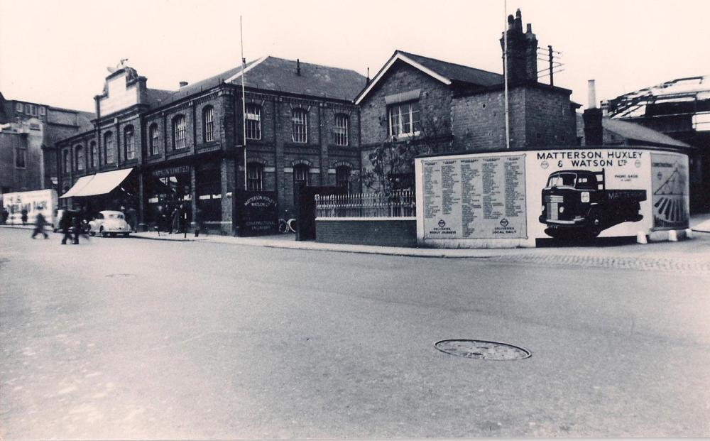
I thought I had shared this one before but this Street level view shows what was then the Matterson's building close-up with the Cocaine Ad in Robs aerial -

|
|
Local History and Heritage -
Aerial views of Coventry
|
Rob Orland
Historic Coventry
|
160 of 177
Fri 13th Sep 2024 11:21am
Hey, nice one! If I have seen it before then I'd completely forgotten it. A lovely rare view, I don't recall seeing that curver corner in such detail before. |
|
Local History and Heritage -
Aerial views of Coventry
|
argon
New Milton
|
161 of 177
Fri 13th Sep 2024 3:04pm
Ref. my post for 'No 6' there are some more postcards of Coventry if the page is scrolled down. A couple were new to me, Fish and vegetable market supposedly Cov and Sir Thomas Whites building |
|
Local History and Heritage -
Aerial views of Coventry
|
NeilsYard
Coventry
|
162 of 177
Fri 13th Sep 2024 4:13pm
Rob looks like I'd put it in the Hales St thread a year or two ago - I've just added another  |
|
Local History and Heritage -
Aerial views of Coventry
|
Annewiggy
Tamworth
|
163 of 177
Fri 13th Sep 2024 4:38pm
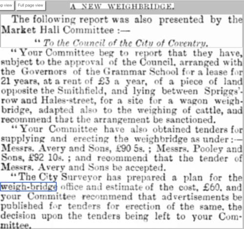
Going back to the weigh-bridge, there are several pictures of similar weigh-bridge buildings on the internet. Looking through the newspaper archive the land it was built on belonged to the grammar school. It was brought to the attention of the corporation in 1905 that since they had rented it from 1888 they had not paid the rent and owed £51 which they duly paid. In 1892 it was ordered that the Contractor for the supply of coal to the hospital be requested to weigh each load on the public weigh-bridge in Hales Street.
This must be the one

|
|
Local History and Heritage -
Aerial views of Coventry
|
rocksolid
Bristol
|
164 of 177
Sat 14th Sep 2024 9:05am
Anne,
Your sleuthing skills are incomparable/superlative etc. Well done, finding this gem. It seems Helen was right , that the bridge was used at least in part, for weighing cattle. Incidentally I am guessing the row of cottages behind the 'hut' is Spriggs'-row?
Does anyone know when the Cattle Market was closed, and was it moved somewhere else? |
|
Local History and Heritage -
Aerial views of Coventry
|
Helen F
Warrington
|
165 of 177
Sat 14th Sep 2024 10:38am
The decision was made to build a big new abattoir and cattle market in Upper York Street near Queens Road and the Butts. This saw the closure of all the weird little slaughter houses throughout the city and made sense because of hygiene and because most of the cattle arrived by train at that point. It was officially opened in October 1932. I believe that the Hales Street site, called the Smithfield market, was closed to all trade in early April 1933. |
|
Local History and Heritage -
Aerial views of Coventry
|

![First page [or press the "F" key] First page](../resource/colour_tint_inc.php?img_file=left-arrow-end.png&clr=AA5511)
![Previous page [or press the "Left arrow" key] Previous page](../resource/colour_tint_inc.php?img_file=left-arrow.png&clr=AA5511)
![Next page [or press the "Right arrow" key] Next page](../resource/colour_tint_inc.php?img_file=right-arrow.png&clr=AA5511)


