mickmitro
tile hill coventry
|
1 of 17
Fri 29th Sep 2017 9:15pm
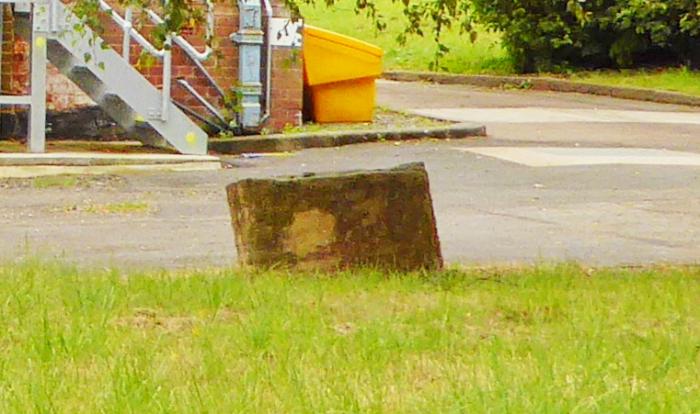
Apologies if this has already been covered but anyone know what stood on the site of the Severn Trent pumping station on Alderminster Road, Mount Nod, I noticed the remains of what look like sandstone columns whilst walking past the other day, it has piqued my curiosity so would appreciate if anyone can solve this for me.
|
|
Streets and Roads -
Alderminster Road, Mount Nod
|
NeilsYard
Coventry
|
2 of 17
Sat 30th Sep 2017 1:34am
I've looked at some old maps Mick but cannot see anything significant on that spot before the station was built. I don't really know the full history of the site but the earliest map I can see it on is 1937. I wonder if the columns were simply just part of an early structure of the station itself.
|
|
Streets and Roads -
Alderminster Road, Mount Nod
|
mickmitro
tile hill coventry
Thread starter
|
3 of 17
Sun 1st Oct 2017 2:51pm
Photos of the pillars:
Photo 1
Photo 2
|
|
Streets and Roads -
Alderminster Road, Mount Nod
|
flapdoodle
Coventry
|
4 of 17
Mon 2nd Oct 2017 12:38am
Fragments of blitz rubble?
|
|
Streets and Roads -
Alderminster Road, Mount Nod
|
mickmitro
tile hill coventry
Thread starter
|
5 of 17
Mon 2nd Oct 2017 1:05pm
It's been suggested that they may be drill core samples but they seem far too big.
|
|
Streets and Roads -
Alderminster Road, Mount Nod
|
Helen F
Warrington
|
6 of 17
Mon 2nd Oct 2017 2:05pm
There is another one, even taller. Bore hole cores doesn't seem implausible. There isn't anything on the map until the pumping station arrives.
|
|
Streets and Roads -
Alderminster Road, Mount Nod
|
mickmitro
tile hill coventry
Thread starter
|
7 of 17
Mon 2nd Oct 2017 10:38pm
Helen F, haven't seen the taller one, I assume it's behind the pump station out of line of sight from the road, I agree about bore hole cores being implausable, I'm surprised, with the vast pool of knowledge etc on this forum, that nobody seems to know where they came from.
|
|
Streets and Roads -
Alderminster Road, Mount Nod
|
Helen F
Warrington
|
8 of 17
Mon 2nd Oct 2017 10:51pm
You can see it on street view if you move further north and look back between the trees.
|
|
Streets and Roads -
Alderminster Road, Mount Nod
|
pixrobin
Canley
|
9 of 17
Mon 2nd Oct 2017 11:40pm
I took a pic of the place in August last year. I have cropped the image down to one of the items in question and enhanced it to get more detail.

|
|
Streets and Roads -
Alderminster Road, Mount Nod
|
Rob Orland
Historic Coventry
|
10 of 17
Tue 3rd Oct 2017 10:41am
On 2nd Oct 2017 12:38am, flapdoodle said:
Fragments of blitz rubble?
I reckon you could be right - they look very similar to the pieces of collapsed cathedral pillar that were taken to the War Memorial Park. |
|
Streets and Roads -
Alderminster Road, Mount Nod
|
pixrobin
Canley
|
11 of 17
Tue 3rd Oct 2017 11:32am
But would they put rubble that close to an important water source?
|
|
Streets and Roads -
Alderminster Road, Mount Nod
|
NeilsYard
Coventry
|
12 of 17
Tue 3rd Oct 2017 11:54am
I do recall seeing them when I used to cut through Alderminster on the way home from Woodlands so they have been there for years. As Helen says, also looked on Old-Maps but it was just empty fields in that area until development arrived. Again no idea why they would put 'rubble' there - unless they need something weighing down perhaps? Although they do look like they are in deliberate lines. I love a good mystery!  |
|
Streets and Roads -
Alderminster Road, Mount Nod
|
Osmiroid
UK
|
13 of 17
Tue 3rd Oct 2017 12:56pm
The bore hole is 700 feet deep and goes through sandstone. Maybe these were left around for reference or just as a bit of interest and no-one got rid of them?
|
|
Streets and Roads -
Alderminster Road, Mount Nod
|
Osmiroid
UK
|
14 of 17
Tue 3rd Oct 2017 1:22pm
|
|
Streets and Roads -
Alderminster Road, Mount Nod
|
OldCaludonian
Peak District
|
15 of 17
Tue 3rd Oct 2017 4:27pm
Osmiroid surely clinches it. The aquifer would be nearer to the surface at the foot of the slope down from Broad Lane.
As a youngster - in late 40s - like many another from Lime Tree Park, I would play in the field which lay between the pumping station and Broad Lane. It was part of Billings's Mount Nod Farm. Access would be gained by a well-trodden route which involved crawling under barbed wire almost opposite Larch Tree Avenue. More conventionally you could use the right of way which ran alongside the tarmacked road which ran from opposite Job's Lane down to the p.s.
In those days there were two features of interest in the field. Just beyond the Larch Tree entrance was 'the Foxholes': a considerable excavation of some antiquity, judging by the age of the trees around it, which I guess was a marl pit. Thirty yards or so further W. were the concrete moorings of a wartime barrage balloon site. In snowy weather the Foxholes were excellent for sledging. Footie was largely confined to the flatter land down towards the pumping station. Best fun was in the field through which 'the Brook' ran. The clay which lined it could be used to make fine water-proof dams. Happy days!
|
|
Streets and Roads -
Alderminster Road, Mount Nod
|