|
Jackie
Sussex |
106 of 113
Wed 19th Sep 2018 3:22am
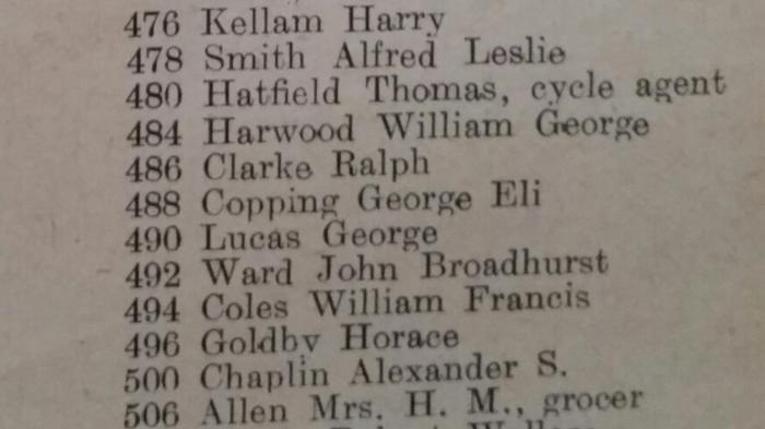
Interesting 492 Woodway Lane not there. Quite a few names mentioned are familiar to me.
Thanks for posting the lists. |
| Coventry Suburbs and Beyond - Woodway Lane and Potters Green | |
|
Kaga simpson
Peacehaven, East Sussex |
107 of 113
Thu 20th Sep 2018 11:25am
Jackie,
The nearest of those cottages to the clod banks woke up one morning to find a giant crater outside the corner of their house. A few yards nearer and the whole house would have toppled in sometime early thirties Several of my relatives are on that list, my grandfather and my father worked the boats along there, but even they did not know the origin of the clod banks. |
| Coventry Suburbs and Beyond - Woodway Lane and Potters Green | |
|
heathite
Coventry |
108 of 113
Thu 20th Sep 2018 11:41am
John Broadhurst WARD 492 Woodway Lane.

|
| Coventry Suburbs and Beyond - Woodway Lane and Potters Green | |
|
Kaga simpson
Peacehaven, East Sussex |
109 of 113
Sun 30th Sep 2018 1:01pm
Annewiggy, re clod-banks.
Most people suspected the clod-banks were 'slag' from the pits, but my family go back to the early 19th century, moving coal from those pits by boat, but I think when I was small I was told no-one seemed to know where the banks came from. Second thoughts they were surplus earth from the canal building?
As a child I did sliding and playing on the clod-banks. It was not coal slag, grass would not grow on it, it was little bits that died quickly. The clod was a sort of sticky oozy green/grey mud with a smell. If you stayed on it long it made you ill. Many parents would not let their kids go near it. Cattle did not go near it. Now after the general strike local people would go gleaning for coal along the railway banks and the fields, but did not touch the clod-banks.
Now this forum has me going back to the books I used to read many moons ago, and the only slag heaps I find other than coal is Iron Ore waste, that deposited lots of green slime that solidifies.
We never knew why officials called it the mineral/coal railway line when it only carried coal, so that fits. To get this Iron Ore they scooped out bowls of earth which filled up with water that turned into ponds, and there were dozens of these ponds round the clod banks, so all in all, I believe they could be hundreds of years old? Have we any experts on geology on the forum? |
| Coventry Suburbs and Beyond - Woodway Lane and Potters Green | |
|
Jackie
Sussex |
110 of 113
Mon 15th Oct 2018 7:15am
Interesting. I remember walking along the burning banks towards the canal, and smelling the sulphur and seeing wisps of smoke coming out.
Do they still burn? |
| Coventry Suburbs and Beyond - Woodway Lane and Potters Green | |
|
PhiliPamInCoventry
Holbrooks |
111 of 113
Mon 15th Oct 2018 10:49am
Hi Jackie |
| Coventry Suburbs and Beyond - Woodway Lane and Potters Green | |
|
Kaga simpson
Peacehaven, East Sussex |
112 of 113
Mon 15th Oct 2018 5:03pm
Philip, when you say ridges did you mean the old railway for that did contain coal, but not the clod-banks. The clod-banks are over a hundred years old, so anything burnable would have gone long ago. The clod-banks never changed shape or had anything added between 1928 and 1944 apart from the tanks and as I posted there were was something wrong for the Army to move away. I know for certain, there wasn't a day went by that I did not see them. When they closed the Craven in 1927 they tidied up pretty good, and Potters Green was as nice a village as you could find in Warwickshire,
Now if you wanted to have seen a bank keep breaking into fire it was the waste tip at Sutton Stop, so much so they had to destroy it in 1939. |
| Coventry Suburbs and Beyond - Woodway Lane and Potters Green | |
|
PhiliPamInCoventry
Holbrooks |
113 of 113
Mon 15th Oct 2018 8:51pm
Hi Kaga, |
| Coventry Suburbs and Beyond - Woodway Lane and Potters Green | |
Website & counter by Rob Orland © 2024
Load time: 501ms