PaulB1973
Coventry
|
406 of 1077
Wed 17th Sep 2014 8:56pm
^ Phillip, that's the other bridge not far away - the Sowe Viaduct further east located behind Corpus Christi School in Ernesford Grange! [Network Rail refer to it as the 'Sow' Viaduct I note] You are looking towards Tarquin Close in Willenhall.
I can tell, due to the lack of that metal palisade-type fence here which is found on the approach and underneath the Sherbourne Viaduct.
|
|
Public Transport and Travel -
Railways around Coventry
|
PhiliPamInCoventry
Holbrooks
Thread starter
|
407 of 1077
Wed 17th Sep 2014 9:07pm
Hi Paul, 
Brill! Thank you.
I walked & waded (in wellies) quite a length of the Sherbourne valley, starting at the Charterhouse, as well as walking back up the Sowe. I negotiated various obstacles, which included broken fencing. That was a few years ago. In fact so long ago, I did not have a mobile that recorded pictures. The picture was off flicr as I stated on the original posting . 
In fact, I have just realised that the picture posted by me is in fact your picture. Brill, brill & brill!
If you are out & about anytime I would love to meet you. We have a forum breaky at Wetherspoons this coming Saturday. |
|
Public Transport and Travel -
Railways around Coventry
|
PaulB1973
Coventry
|
408 of 1077
Thu 18th Sep 2014 10:05pm
Ha, I was being modest! The area near the Whitley refuse centre looks very enclosed with trees & overgrowth and the like. The Sowe Viaduct is a little more open but not much so. Its amazing to think these structures are well over 160 years old, but mostly hidden away! I do carry a little digi-cam with me although I'm not a serious photographer.
Alas, this-coming Saturday I am at work (working for an organisation that use little red vans popping envelopes through people's letterboxes!) although I'll be free later, failing that I'll still be on here, Flickr, Twitter, Facebook and the normal social media outlets. I like to hang-out at the Town Wall Tavern on Sunday for an early afternoon roast meal too!
|
|
Public Transport and Travel -
Railways around Coventry
|
PhiliPamInCoventry
Holbrooks
Thread starter
|
409 of 1077
Thu 18th Sep 2014 10:45pm
Hi again Paul,
I have enjoyed a pint of Bass in the Tavern but never a nosh, but that will now be on my list to try. You will be pleased, you will, you will, that I am a top-star eBayer, so I do my bit to keep those little red vans on the move.
On the subject of red vans, I do miss the hype of times past where mail was being loaded & offloaded at Coventry station. Them wert-days!
|
|
Public Transport and Travel -
Railways around Coventry
|
DBC
Nottinghamshire
|
410 of 1077
Fri 19th Sep 2014 5:32pm
Growing up in Stoke Aldermoor we used to fish for tiddlers in the Sowe very close to that viaduct. I found is a bit scary actually walking under it. There used to be a footpath leading from there, along the banks of the river before coming out on to what is now Allard way, but which used to be a much smaller road. There was another spooky place along that footpath. It was the old Pinley smallpox hospital, which in the 1950's was being used as some sort of store for hospital supplies. It stood all alone, looking very grim, just like something out of a Dickens novel. |
|
Public Transport and Travel -
Railways around Coventry
|
PaulB1973
Coventry
|
411 of 1077
Fri 19th Sep 2014 9:43pm
I moved into the Ernesford Grange area when I was about 5 in the late 1970's - before Allard Way was built, although I certainly remember its (and the associated large rail bridge) construction. It was completed in early 1981 I think. I'm pretty-sure there was a footpath and bridge under the rail line [since filled in] leading from The Coppice down to what is now Allard Way before the large bridge was built. Langbank Avenue, which of-course connects with Allard Way, was a dead-end stub until this period, meaning local bus service 9 (later 29) had to use a purpose built terminus outside Corpus Christi School.
|
|
Public Transport and Travel -
Railways around Coventry
|
DBC
Nottinghamshire
|
412 of 1077
Sat 20th Sep 2014 4:22pm
There is also a footpath leading from the end of Michell Close, over the railway to Humber road and then onto London Road. We used to cycle that way from Stoke Aldermoor to Whitley Abbey school. The Michell Close bridge was one of our favourite train spotting locations. |
|
Public Transport and Travel -
Railways around Coventry
|
matchle55
Coventry
|
413 of 1077
Sat 20th Sep 2014 4:44pm
On 19th Sep 2014 9:43pm, PaulB1973 said:
I moved into the Ernesford Grange area when I was about 5 in the late 1970's - before Allard Way was built, although I certainly remember its (and the associated large rail bridge) construction. It was completed in early 1981 I think. I'm pretty-sure there was a footpath and bridge under the rail line [since filled in] leading from The Coppice down to what is now Allard Way before the large bridge was built. Langbank Avenue, which of-course connects with Allard Way, was a dead-end stub until this period, meaning local bus service 9 (later 29) had to use a purpose built terminus outside Corpus Christi School.
The railway bridge over Allard way was constructed on its own set of tracks and when it was finished the existing track and embankment was removed over a weekend and the bridge was pushed into position using large hydraulic cylinders. A large shutter was then formed around the temporary wheels on the base of the bridge and an epoxy resin was poured in to keep the whole thing permanently stable. The firm I worked for supplied a large number of industrial heaters to keep the resin at a constant temperature until it had set. We were on standby just in case there was any problems. From what I recall it took a fair while to push the bridge in to place but it was near inch perfect and the trains were running on Monday morning. It was a fascinating job to be involved with. I think the date was around 79/80. |
|
Public Transport and Travel -
Railways around Coventry
|
PaulB1973
Coventry
|
414 of 1077
Sat 20th Sep 2014 10:25pm
I know we had family at home for my sisters christening, who later on went for a walk to look at the bridge and road - that was spring/summer 1980. On quiet Sunday mornings, my dad, brother & I strolled around the yet-to-completed road and site a few times - with practically no construction workers on-site, we were left to our own devices. I think I recall 'Fairclough' signs on the bridge.
|
|
Public Transport and Travel -
Railways around Coventry
|
Ron
Back home in Coventry
|
415 of 1077
Thu 25th Sep 2014 8:40pm
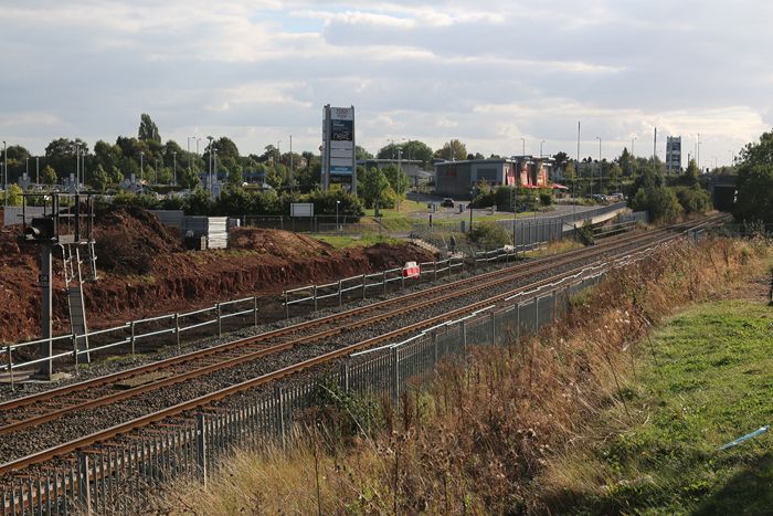
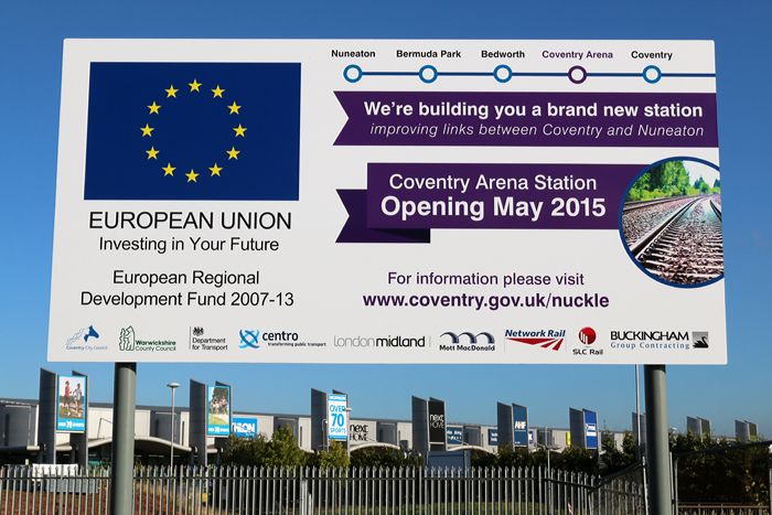
It's quite staggering how much progress can be made with large building projects in such short periods of time these days.
Contractors were allowed access to the site for the new station at the Ricoh on 1st September.
Work has only commenced so far on the 'up' line (ie. the line towards London [via Coventry of course]). Clearly the signal that currently 'sits' in the middle of the platform will have to be resited.
This image was taken yesterday afternoon. Whilst there, signage was being erected that inform that 'Coventry Arena' station will open in May 2015.
|
|
Public Transport and Travel -
Railways around Coventry
|
NeilsYard
Coventry
|
416 of 1077
Thu 25th Sep 2014 9:09pm
Nice one Ron - looks like getting to the game will be a lot easier! |
|
Public Transport and Travel -
Railways around Coventry
|
Ron
Back home in Coventry
|
417 of 1077
Fri 26th Sep 2014 11:08pm
The progress made to date on the 'up' side can clearly be seen in this morning's image, taken just before a chance meeting with Philip (many thanks for the coffee!!).
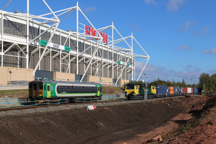
By some stroke of luck, the Nuneaton-bound 'dogbox' is passing just as the Crewe to Southampton liner (the first of three such trains within an hour and 40 minutes) heads south.
The now 'misplaced' signal can clearly be seen in front of the Class 70 loco. I understand this is to be relocated imminently by Network Rail. |
|
Public Transport and Travel -
Railways around Coventry
|
Ron
Back home in Coventry
|
418 of 1077
Sat 4th Oct 2014 1:34pm
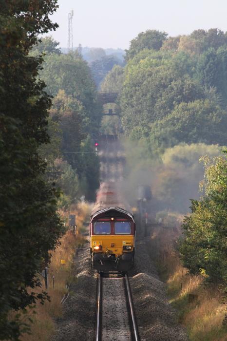
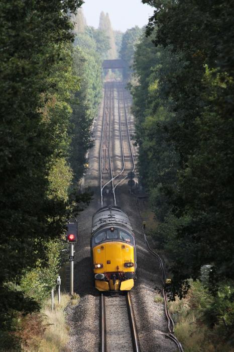
A long lens shot taken yesterday inside the City boundary.
It is taken off the Stoneleigh Road bridge at Gibbet Hill, and is looking towards Kenilworth, the bridge you can see in the background being Common Lane.
This section of track on the Coventry to Leamington line has always been single. Although expected to be doubled in the forthcoming big upgrade of the Nuneaton - Coventry - Leamington spine, the last plan to double in the 1930s was scuppered by the outbreak of the Second World War, despite the land always having been owned to enable this work to be carried out.
As well as the deep cutting, a major engineering work on this section was Milburn Grange viaduct. At one time consisting of 8 arches, it has gradually been reduced in size, the last major work being in the 1980s.
Milburn Grange sits at the lowest point in this view. The whole of the Coventry to Leamington line is one great switchback, with some dips being big enough to lose a whole Freightliner train from view, dependent on your viewpoint.
HS2 - should it be built - will cross this view at right angles on the Coventry side of Milburn Grange. This emphasises just how close HS2 will run to the City of Coventry.
For those that might be interested, the train is one of three long trains that run each day, 6 days per week, connecting the Jaguar Land Rover plant at Halewood with Southampton Docks. Land Rover Evoques are exported worldwide from Southampton; this is a train of empties returning to Halewood. After reloading, it will return back through the Midlands around 12 hours later with yet another load for export. |
|
Public Transport and Travel -
Railways around Coventry
|
Ron
Back home in Coventry
|
419 of 1077
Sat 4th Oct 2014 1:42pm
This is the view looking towards the City from Stoneleigh Road bridge. The gradients and dips are exaggerated by the long lens.
Here a train is coming off the double track section from Coventry and is heading towards Kenilworth.
The road bridge in the background is Kenpas Highway, close on a mile and a half away.
The double track visible in this view was only reinstated in 2006, having been reduced to single track in the very late 1960s as an economy measure.
|
|
Public Transport and Travel -
Railways around Coventry
|
Midland Red
|
420 of 1077
Wed 8th Oct 2014 12:47pm
Great photos, Ron - thanks for posting |
|
Public Transport and Travel -
Railways around Coventry
|

