|
Prof
Gloucester |
1 of 18
Mon 5th Nov 2018 6:30pm
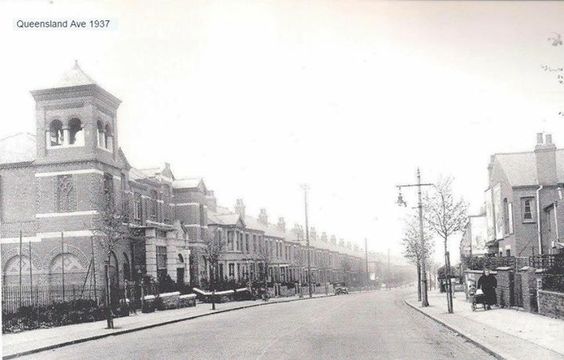
Hearsall Lane with the Hearsall Baptist Church in view with the square tower. Further down would be found
the Church of St Mary Magdalene (the church with the blue tiled roof).
 |
| Local History and Heritage - Hearsall | |
|
matchle55
Coventry |
2 of 18
Mon 5th Nov 2018 7:03pm
I think this incorrect - as the picture says, it's Queensland Avenue. Hearsall Lane is to the photographer's right.
St Mary Magdalene is behind the houses on the immediate right. I was married there in 1971.
|
| Local History and Heritage - Hearsall | |
|
Midland Red
|
3 of 18
Mon 5th Nov 2018 8:27pm
Quite correct, matchle55
 . . . and St Mary Magdalene on the corner of Sir Thomas White's Road
 |
| Local History and Heritage - Hearsall | |
|
Prof
Gloucester Thread starter
|
4 of 18
Mon 5th Nov 2018 10:57pm
I stand corrected matchle55! Just shows how long I've been away from Coventry. I was at my aunt's wedding in 1947 at Hearsall Baptist Church. Now I see Queensland Avenue I remember the name.
|
| Local History and Heritage - Hearsall | |
|
Midland Red
|
5 of 18
Tue 6th Nov 2018 8:47am
Another view of Hearsall Baptist Church (opened 1928)
 In 1961 a "new" Hearsall Baptist Church opened, adjacent to the older building

|
| Local History and Heritage - Hearsall | |
|
Billybobs
South Warwickshire |
6 of 18
Tue 6th Nov 2018 11:11am
This is a tremendous site. Yet again articles and photos that bring back memories, this time the photo of the original Hearsall Baptist Church. I recall when attending Hearsall Junior School in Kingston Road, the church was used as an overflow and I remember having lessons in rooms on the top floor. Always a favourite of mine, on the way home (circa mid 50's) I would pop into the Kudos on Hearsall Lane (see Shops of Yore) for pennyworth of sweets, wonderful memories.
Also there was a Woodlands RE teacher, Mr Rollason who I believe was the minister at the Baptist Church. He was a gentleman of the 'old school' who treated all with respect, one of the few who did at that school.
Once again thanks Midland Red for the memories
|
| Local History and Heritage - Hearsall | |
|
Midland Red
|
7 of 18
Tue 6th Nov 2018 4:53pm
Billybobs, thank you

|
| Local History and Heritage - Hearsall | |
|
NeilsYard
Coventry |
8 of 18
Tue 6th Nov 2018 6:51pm
All Souls is 'my' church. I was baptised / took first communion and married there - as well as my parents married there too and where most of our family occasions (and funerals?!) are. It's lovely inside.
|
| Local History and Heritage - Hearsall | |
|
JayC
Coventry |
9 of 18
Thu 16th Apr 2020 8:39pm
Does anyone know if the stretch of old sandstone wall on Hearsall Lane is part or the original City wall that was relocated? Thanks.
Post copied from topic City Wall and Gates (inc. Cook Street) on 25th Apr 2020 5:06 pm
|
| Local History and Heritage - Hearsall | |
|
Helen F
Warrington |
10 of 18
Thu 16th Apr 2020 9:59pm
Hi JayC, Prof
It's certain that bits of the wall ended up all over the place as it was surprisingly intact in 1749 but was still being robbed during the 20th century. However the stretch of old wall on Hearsall Lane might belong to the leper hospital that was in that location. Its boundary went up to the Allesley Old Road but I'm not sure how far it extended in the other directions.
Info about the leper hospital including a map
 Not all bits of wall belong to the old city as the red sandstone quarries continued in operation and there was such a quarry on the other side of the Hearsall Lane to the wall.
 |
| Local History and Heritage - Hearsall | |
|
NeilsYard
Coventry |
11 of 18
Fri 17th Apr 2020 9:53am
Jay, are you referring to this bit?
|
| Local History and Heritage - Hearsall | |
|
JayC
Coventry |
12 of 18
Fri 17th Apr 2020 11:19am
On 16th Apr 2020 9:59pm, Helen F said:
Hi JayC, Prof
It's certain that bits of the wall ended up all over the place as it was surprisingly intact in 1749 but was still being robbed during the 20th century. However the stretch of old wall on Hearsall Lane might belong to the leper hospital that was in that location. Its boundary went up to the Allesley Old Road but I'm not sure how far it extended in the other directions.
Info about the leper hospital including a map
Hi Prof. Thanks for this. I knew of the leper hospital but didn't associate the wall with this. It makes obvious sense. Thanks.
 Not all bits of wall belong to the old city as the red sandstone quarries continued in operation and there was such a quarry on the other side of the Hearsall Lane to the wall.
 |
| Local History and Heritage - Hearsall | |
|
JayC
Coventry |
13 of 18
Fri 17th Apr 2020 11:22am
On 17th Apr 2020 9:53am, NeilsYard said:
Jay, are you referring to this bit?
Hi Neil. Yes that's it. Think it is a lot higher at the bottom of the road. |
| Local History and Heritage - Hearsall | |
|
NeilsYard
Coventry |
14 of 18
Fri 17th Apr 2020 11:58am
I've mentioned before about the amount of sandstone walling in the Barras Lane area. It's difficult to determine where it all came from but as Helen suggests the hospital is the likelihood in that area. I like stumbling across little bits here and there that are hidden away today.
|
| Local History and Heritage - Hearsall | |
|
Helen F
Warrington |
15 of 18
Fri 17th Apr 2020 1:49pm
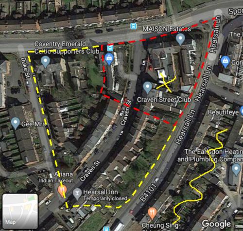
Since Coventry sandstone is quite soft the walls and buildings age quite quickly. Soft sandstone is great for shaping and carving, which explains why Coventry's wall was noted for its dressed even blocks but it was always being repaired. The walls along Hearsall Lane are a variety of ages and the gaps for steps are likely to be connected to the modern housing, some of which had been built by 1850. The red line is one possible boundary and the yellow is another. These are guesses based on the maps. While the real shape could have been anything, often boundaries and roadways survive long after the reason they were built for has gone.
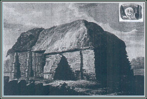
The yellow X is where the leper hospital was supposed to be and the yellow wiggle is where the sandstone quarry was. The 1850 map looks like a lot of the red dotted line was hedge but the images of the hospital look like it was enclosed with a wall. However by that time the hospital was being used as a barn so maybe a farmer was responsible for the older parts of the walls.
 I'll move most of this to the section about the leper hospital in a few days.
|
| Local History and Heritage - Hearsall | |
Website & counter by Rob Orland © 2026