|
Annewiggy
Tamworth |
16 of 92
Sun 14th May 2017 11:54am
Hi Rob. The map is one from the collection of stuff I bought from Stan Beasley. It is called Coventry circa 1750 and with major features in late medieval times. The rest of it you put on some time ago for me and is under the Historic Coventry button, street maps, old maps scans. There is a lot of ditches etc marked on it. There is no clue as to who produced it but there is a stamp in the corner that you can just read Coventry City so I presume it came fro the archives. The keep is marked on the map, not a later addition. Stan was obviously interested in ancient Coventry as there is a lot of sketches of maps he has made, He also has road names etc. in the Latin form. The only mention of the map I can find online is to a 1970's book by J C Lancaster, whether she is responsible for the map or just used it I don't know. I will look through his thing again and see if there is any other mention. The only thing I could find about Archaeology in the area online is a page about Birmingham University doing a dig but it does not say when. I will keep digging (no pun intended !) |
| Local History and Heritage - Coventry Castle | |
|
Helen F
Warrington |
17 of 92
Sun 14th May 2017 1:49pm
The map is the same as at the Historic Towns Atlas
The map seems to be a mix of the modern (late 1800s) maps and the 1750 Bradford map, plus information about ditches etc from somewhere else. Maybe from the work of Joan C. Lancaster, archivist for the City of Coventry 1946-48? The ditches pop up in excavations and will be in the archaeology records but accessing them is another matter. Perhaps the presentations in September (see event diary) might shed light on them?
Joan includes this - John Stow writing after 1579 described it as the 'fortelet or pile standing in the earles streite, where the earles of Chester did make theyr abode which they afterwards decayed and turned into tenements.'
Which would put it east of Hay Lane but not necessarily on the south side of Earl Street. Apart from a few lumps and bumps, the land is fairly flat at the west end of Earl Street and the High Street. There is a slightly higher block between the Rose and Crown and The Craven Arms. There's another mound straddling Pepper Lane and Derby Lane and curiously the Trinity and St Michael's boundaries go round it, though not in the way you'd expect if it was the Lord's half.
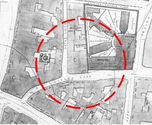 |
| Local History and Heritage - Coventry Castle | |
|
Helen F
Warrington |
18 of 92
Sun 14th May 2017 3:20pm
Rob, I'm favouring the concept of many hands make light work. With more information available for all to study, links can be made that couldn't be before because different people had different parts of the whole picture. As I've been modelling, new questions keep popping up but answers are turning up too. I've spotted mistakes I made in the picture sheets, because when I plot them on the ground, I realise that there's a building missing or that a pub must have moved, simply because the image doesn't fit the footprint with the name on it, or its neighbours aren't in the right position. Without the range of information I've been able to get hold of, I couldn't have told that there was a problem, let alone solved it. I've picked up bits of the archaeology from books but often the information lacks something as basic as a map of where they were digging, especially in relation to the old maps. While their knowledge of the archaeology might be exceptional, they know much less about the images and/or don't trust them. It takes an artist's eye to understand what the sketches are trying to say. Once I have a basic model of the city, some of the archaeology might fill in some details. eg reading Coventry, the Hidden History has told me some things about the oldest part of the Cheylesmore Manor. The building was stone and built into the wall, making it one of the towers and at the very south of the complex. Not, as the Historic Town Atlas suggests, in the middle of the manor. |
| Local History and Heritage - Coventry Castle | |
|
AD
Allesley Park |
19 of 92
Sun 14th May 2017 7:54pm
Wow - I'm really impressed by how deeply people are going into the thought and reasoning of this - top work!
I like Helen's reasoning and it would certainly make sense for them to build around the existing wooden defence and then demolish that after completion so there wasn't any vulnerability. It would also make sense in terms of labour saving - if you're rebuilding in stone rather than wood then the new wall is going to need a much deeper foundation and why dig a new foundation trench when you've already got one at least partially dug with the existing defensive ditch? Then when you dig the new defensive ditch further out for the new defences you can just use the spoil to fill in around the foundations. Just a guess.
Going off topic now and into fantasy realm but I'd also like Helen's theory on the position of the original keep to be correct because it's where I've placed it in my remodelled Broadgate. It creates the southern edge of a public square/pocket park on the site of Cathedral Lanes with Holy Trinity as the northern boundary and old Cathedral to the east. The west is open but makes a route between Greyfriars Lane and Trinity St, with the existing square retained to link up all the routes.
But I certainly think Caesar's Tower is likely to have been a part of the stone keep - I just can't see any other building being that substantial or incorporating the defensive measures it appears to have and it doesn't seem like it's in the right position to be part of the curtain wall. |
| Local History and Heritage - Coventry Castle | |
|
Helen F
Warrington |
20 of 92
Sun 14th May 2017 10:54pm
It's worth noting that the keep isn't the real living quarters of a castle. It's the most defendable part that the people withdrew to if the castle was attacked and the outer defences failed. It was often used as a jail in peacetime because it was as hard to get out of as it was to get in. Caesar's Tower might have been part of the hall complex in an inner bailey. That could have been north, south, east but probably not west of the tower as it slopes down to where the earliest gate was probably sited. The gate/s would usually be as far from the motte as possible so that invaders would have to negotiate the inner defences before arriving at the keep.
Another feature of the motte/keep would have been a well. Has there ever been one in the Pepper Lane, Derby Lane area? |
| Local History and Heritage - Coventry Castle | |
|
AD
Allesley Park |
21 of 92
Mon 15th May 2017 12:32am
I remember from school that the keep wasn't used every day despite being the biggest and most substantial building as it was an absolute last resort - a medieval Trident if you will.
But I think it would've been a keep because its position is too far away from any of the suggested curtain wall routes unless the tower had a MASSIVE footprint and there is very little evidence of a route into the castle here. They'd only one entrance/exit (two at most) to limit potential attack points and that would have most likely have been Broadgate.
Then there is the defensive structures it contained according to the Rob's snippet in #11 - facing the main entrance onto Broadgate, battlements, bow apertures, low doorways and exterior stair entrance etc. These are things you expect on a medieval keep, not domestic buildings which would've been sacrificed if the curtain wall was breached.
But for me the biggest clue is the sheer size - four storeys, foundations over 12 feet deep, 6 feet thick walls at least. No domestic building would be that substantial, not even a great hall which was usually only two storeys.
So given this my money is on it being part of the keep. Of course it could be part of the wall and no-one has got the true route of the wall correct yet. But I'm confident this wouldn't have been everyday domestic (but must've been able to perform some domestic functions like cooking etc. in an emergency)
Rob's snippet does also contain reference to two wells in the undercroft? The one on Broadgate island would've been too far away but may have served the outer castle?
|
| Local History and Heritage - Coventry Castle | |
|
Helen F
Warrington |
22 of 92
Mon 15th May 2017 9:02am
 Classic wooden castle.
 |
| Local History and Heritage - Coventry Castle | |
|
AD
Allesley Park |
23 of 92
Mon 15th May 2017 1:28pm
Like I say it could certainly be a part of a curtain wall, just the wall isn't quite where people have guessed it was. Others keeps have much thicker walls. It's not quite on the highest part of the hill etc.
But that then brings back into question the issue of 'St Michael in the Bailey' - if Caesars Tower is part of the rebuilt stone wall and the old cathedral is on the site of the old chapel then the chapel will be outside the Bailey. All I'm pretty sure of is it served a defensive rather than domestic purpose - it's far too substantial.
Maybe it could've been part of an inner curtain wall and a second wall further out encompassed the chapel? But I think there'd be far more evidence of stonework and foundations in later redevelopment if there was an inner and outer wall, and then a keep as well. When I think of what Coventry Castle may have looked like I think of things like Cardiff. |
| Local History and Heritage - Coventry Castle | |
|
Helen F
Warrington |
24 of 92
Tue 20th Jun 2017 8:50pm
So I was prompted into looking again at J.B. Shelton's articles kindly provided by Rob. While Shelton didn't know where the castle was he gives clues on how it was built. I'll be honest, the first time I read the articles, they didn't make much sense to me. Details I didn't understand about places I could fit into the layout of the city. To make sense of how castles are constructed I'd recommend 'The Secrets of the Castle' a BBC prog about a new French castle being built by experimental archaeologists.
What essentially happened was a rocky, clay mixed outcrop in a river/lake basin was deemed a suitable location to build. It had all the key ingredients. Water, trees, clay and stone. The process seems to be similar for all of the stone buildings although some of the dressed stone was a white/yellow sandstone, so may have come from very specific locations. Even in the same area, sandstone comes in a range of colours and hardness. A lot of Coventry sandstone is lusciously red but quite soft. Great for carving, especially with medieval tools but not so good for longevity, which is why a lot of the old stuff is melting away. The mortar for the stonework was clay mixed with slaked lime and even by Shelton's day was harder than the rock to break up. The clay was also used in the daub part of wattle and daub houses. That was then made weatherproof with a coating of lime wash.
Around the castle site, quarries were started. Stone from Broadgate; clay from where Boots was built near the market; sand and gravel from the Burges. The quarries were sometimes over 30ft deep. Initially the pits were used as shelter and even buildings were constructed inside. Into these pits, rubbish and a lot of dung was deposited. In addition cellars were often sunk and new buildings constructed over centuries of rubbish. One particular row of cellars excavated by Sheldon were under this range of buildings.
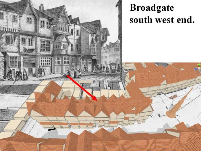 You can see the doors to the cellars in the drawing. So even in construction, the castle was being ringed by very deep ditches.
Everywhere Shelton dug seemed to be mostly pits filled with animal dung, so Coventry is largely built on poo.
 |
| Local History and Heritage - Coventry Castle | |
|
Helen F
Warrington |
25 of 92
Tue 20th Jun 2017 9:07pm
For information along the same lines. Where there wasn't rock to build on, a lot of Coventry was marsh (remainder of the dwindling lake). Into this massive beams were sunk and the stone structures build on top. Even the gates were supported by wooden piles, kept strong by the bog water they sat in. Before the area of Pool Meadow was surrounded by the city wall, there was a third tower in line with Cook Street tower and the Hales Street gate, hard up against the river. It was so boggy/flooded that it was entirely supported by piles that would have had to be sunk into water 3ft deep. |
| Local History and Heritage - Coventry Castle | |
|
Helen F
Warrington |
26 of 92
Mon 31st Jul 2017 12:34am
 I found this reconstruction of early Kenilworth castle. Looking at it, it shows that the first roads in the Bailey came out from the castle proper. If we assume that Bayley Lane does the same then it wouldn't be the northern edge of the Bailey, but it starts at the drawbridge. If we look at the picture the keep was directly to the side of the gate. What was directly to the side of the start of Bayley Lane? The old prison or Gaol that Pepper lane was formerly named after. On the 1750 map the prison even seems to have towers on the north edge. It was not uncommon for the keep of a castle to be used as a prison because just as it was hard to break into, it was hard to break out of. The standard practice was that the lower rooms or cellars were used for the poor and the nicer, Lord's apartments were used for wealthy prisoners, especially those who were to be ransomed. Worth a thought?
By and large the keep wasn't the living quarters but the emergency bolt hole. Finer, but less safe apartments were located somewhere away from the gate. That might put them on the High Street side of the castle enclosure. Eventually the surrounding ditch would be filled in and properties would be built on the space.
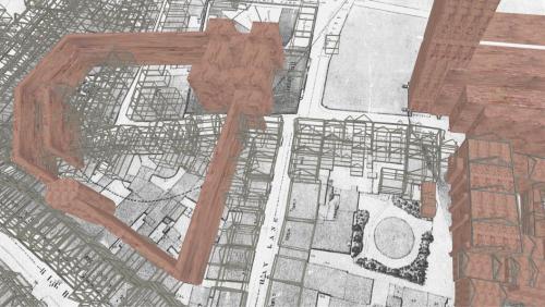 Above is a rough idea of where the Inner bailey and keep might have stood. What do you think?
|
| Local History and Heritage - Coventry Castle | |
|
Helen F
Warrington |
27 of 92
Thu 16th Aug 2018 11:39pm
So I've found a series of lists for vaulted cellars and I'm more sure than ever that a lot of them were sunk into the various ditches. That includes the crypts in St Michael's. I think that was the northern edge of the stone walled bailey. I'm guessing that the Herbert crypt is at the eastern edge of the earliest bailey ditch with the steps down following the slope of the outer edge. The little window looks north along the ditch. The southern end of the bailey seems to have run along the southern edge of St Mary's kitchen. That gives the ditch crossing St Mary's Street at the location of the Half Moon Tavern/Great Drapery. Significant? I'm not sure where the western end of the motte was but the parish 2/3 circle on the map would be just right for the motte and the land there was still raised slightly. That motte and bailey castle may have been in wood, though it does pass Caesar's tower so it may have had a stone wall for a while.
I think that they built the stone castle round the outside. The picture below is a guestimate based on the map and medieval cellars. The Red Ditch runs east to west but there were reports of cellars/voids running north from Gosford Street. There were theories that it was an escape tunnel but it was most likely to be features set into the earliest ditches for the town. The Xs mark the rough locations of the crypts. There may be more. There was a crypt recorded for the Sword and Mace and I wonder if it was at the street front or back off the road where the bulk of the pub was located.
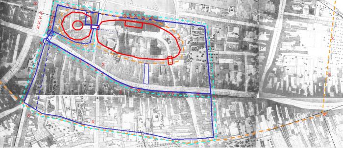 I need to get a look at the excavation in Broadgate and Derby Lane. The crypt under the bank at the north end of Greyfriars Lane suggest the ditch ran that way and there was a stone wall running along the west side of the lane. The cellars under the east side of Broadgate seem part of the castle ditch but the ones on the west side are probably sunk into a quarry.
|
| Local History and Heritage - Coventry Castle | |
|
Prof
Gloucester |
28 of 92
Thu 27th Sep 2018 10:41pm
|
| Local History and Heritage - Coventry Castle | |
|
Helen F
Warrington |
29 of 92
Sat 29th Sep 2018 9:00am
Yes Prof, I think the gateway into the castle inner bailey would have been right there, with the keep on the right. I read yesterday that they found evidence of ditch below the left hand corner plot. |
| Local History and Heritage - Coventry Castle | |
|
Helen F
Warrington |
30 of 92
Wed 7th Nov 2018 3:35pm
Link to an academic journal piece about interpreting maps, including details about Coventry castle.
Conference video incluing one about half way down about the same technique
Prof Keith Lilley, Queens University Belfast kindly came to talk about the work he'd done back in Sept 2017. It's a complicated issue but an essential read if you want to wonder where the castle was.
|
| Local History and Heritage - Coventry Castle | |
Website & counter by Rob Orland © 2024
Load time: 731ms